
A New and Accurate Map of the World. Drawn from the best Surveys and regulated by Astronomical Obs...
- People
- Time
- Owner Organization

A new chart of the Pacific Ocean : exhibiting the western coast of America, from Cape Horn to Beerings Strait, the eastern shores of Asia including Japan, China and Australia and all the numerous islands and known dangers situated in Polynesia and Australasia / correctly drawn and regulated according to the most approved and modern surveys and astronomical observations by J.W. Norie

A New and Accurate Map of the Colony of Massachusets Bay, In North America from a Late Survey

A New and Accurate Map of the Colony of Massachusets Bay, In North America from a Late Survey

A New and Accurate Map of the Empire of Japan Laid down from the Memoirs of the Portugese and Dutc...
A new & accurate map of Asia : drawn from the most approved modern maps & charts / by Thos. Bowen ; engraved for Middletons complete system of geography

A new and accurate map of the Empire of Japan : laid down from the memoirs of the Portuguese and Dutch, and ...

A New Map of the Whole World According To The New Observations by Moll Geographer

A new and accurate map of the Empire of Japan. Laid down from the memoirs of the Portuguese and Du...

A New & Accurate Chart of the Discoveries made by the late Capt. Js. Cook, and other distinguished...

Japan & Corea. The Illustrations by H. Warren & Engraved by J.H Kernot. The Map Drawn & Engraved b...

Japan & Corea. The Illustrations by H. Warren & Engraved by J.H Kernot. The Map Drawn & Engraved b...
A new map of India & China from the latest observations / by I. Senex

An Accurate Chart of the World, with the New Discoveries; Also a View of the General & Coasting Tr...
Port Moresby : sketch map of the barracks and vicinity drawn from aerial photographs

Topographical map of the Japanese Empire, 1899 / Imperial Geological Survey of Japan ; drawn by T. Togawa an...

A Correct Map From Actual Surveys And Examinations Embracing A Portion of California Between Monte...
The world. compiled and drawn by the American Geographical Society for the Department of State ; lith. A. Hoen & Co., Inc

Map of Asia

The New War Map of Maryland Part of Virginia & Pennsylvania. Published by B.B. Russell . .
Tower on road to Florence, and used as observation post, shelled by New Zealand tanks in World War II - Phot...
A new plaine and exact map of Asia / described by N.I. Vischer and rendered into English with habits of the countries and manner of the chiefe citties

A New and Correct Chart of all the Known World Laid down according to Mercator's Projection

A New and Correct Chart of all the Known World Laid down according to Mercator's Projection

A New and Correct Chart of all the Known World Laid down according to Mercator's Projection

Tō "So" jūmanbun no ichizu

Mare Del Sud Detto Altrimente Mare Pacifico

Mare Del Sud Detto Altrimente Mare Pacifico
A new and accurate map of the Empire of Japan : laid down from the memoirs of the Portuguese and Dutch, and ...

Hemisphere Septentrional pour voir plus distinctement Les Terres Arctiques . .
-

上佐嘉下郷五領村

Plan de la ville de Meaco / Dheulland sculp

Carte générale d'une partie d'Afrique et d'Asie depuis le détroit de Gibraltar jusqu'aux isles du ...

Asahikawa, Kamikawa Sub-prefecture, Hokkaido, Japan
小倉西市中小倉兵・長兵戦争要図

Greece in the fifth century B.C

[Oranda shinyaku chikyu zenzu : The complete map of the whole World, newly translated from Dutch s...

Hemisphere Septentrional pour voir plus distinctement Les Terres Arctiques . . . Corrige et Augmen...

「東海道五十三次」 「赤坂」
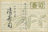
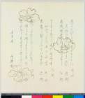
小田原屋 清寿司
![和泉国[畿内図]](https://rmda.kulib.kyoto-u.ac.jp/iiif/RB00020010/RB00020010_00001_0.ptif/full/200,/0/default.jpg)
和泉国[畿内図]
Index to Admiralty charts of Nakai or Inland Sea, Korea Strait, Okhotsk Sea, Kamchatka and Peter the Great Bay / Hydrographic Office
![Japan [cartographic material] : railroads and railroad facilities](https://stacks.stanford.edu/image/iiif/yv242dj2410%2Fyv242dj2410_00_0001/full/!200,200/0/default.jpg)
Japan [cartographic material] : railroads and railroad facilities
A New Map of the Whole World According To The New Observations by Moll Geographer
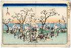
「江都名所」 「御殿山遊興」

Pars Globi terrestris Ao. 1492 a Martino Behaim Equite Lusitano Norimbergae confecti Delineavit Ch...

Plan de Yokohama / par Sadahidé Hashimoto Gyokuransaï
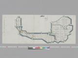
陸奥(完成図)横12.3.9〔横断図面〕
Last Updated: 2020-04-17
Uploaded: 2021-09-21