
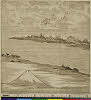
A Correct Map From Actual Surveys And Examinations Embracing A Portion of California Between Monte...
- People
- Time
- Owner Organization

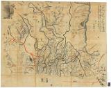
Map of Colorado Territory, Compiled from Government Maps & Actual Surveys. Made In 1861

Map of Colorado Territory, Compiled from Government Maps & Actual Surveys. Made In 1861

Map of Colorado Territory, Compiled from Government Maps & Actual Surveys. Made In 1861

Map of Colorado Territory, Compiled from Government Maps & Actual Surveys. Made In 1861

A New and Accurate Map of the World. Drawn from the best Surveys and regulated by Astronomical Obs...

A New and Accurate Map of the Colony of Massachusets Bay, In North America from a Late Survey

A New and Accurate Map of the Colony of Massachusets Bay, In North America from a Late Survey
A new map of India & China from the latest observations / by I. Senex

A new & correct chart of the Indian sea from Cabo Bonea Esperanca to Japan : according to Mr Edwar...
A new & accurate map of Asia : drawn from the most approved modern maps & charts / by Thos. Bowen ; engraved for Middletons complete system of geography
World War II soldiers from a New Zealand Division flash spotting troop surveying a concentration board, Cass...

Chinese men-of-war near Yanghea sea firing upon a portion of the fifth infantry regiment, which is in pursuit of the Chinese fugitives along the shore from Yangheatun towards Wei-Hai-Wei
The country trade East-India pilot, for the navigation of the East-Indies and oriental seas, within the limits of the East-India Company, extending from the Cape of Good Hope to China, New Holland and New Zeeland, with the Red Sea, Gulf of Persia, Bay of Bengal, and China Seas / chiefly composed from actual surveys and draughts communicated by experienced officers of the East-India Company, and from the Neptune oriental by M. d'Apres de Mannevillette

A new chart of the Pacific Ocean : exhibiting the western coast of America, from Cape Horn to Beerings Strait, the eastern shores of Asia including Japan, China and Australia and all the numerous islands and known dangers situated in Polynesia and Australasia / correctly drawn and regulated according to the most approved and modern surveys and astronomical observations by J.W. Norie
The Suma oriental of Tomé Pires : an account of the East from the Red Sea to Japan, written in Malacca and India in 1512-1515; and, The Book of Francisco Rodrigues, rutter of a voyage in the Red Sea, nautical rules, almanack and maps written and drawn in the East before 1515 (Map in pocket of vol.2: The east, from the Red Sea to Japan, as known to Francisco Rodrigques)

Quail and Millet
Laurie and Whittle's new chart of the Indian and Pacific Oceans between the Cape of Good Hope, New Holland, and Japan, comprehending New Zealand, New Caledonia, New Britain, New Ireland, New Guinea,&c., Louisiade and New Georgia; also the Pelew, New Caroline, Ladrone, and Philippine Islands; &c. with the most remarkable tracks of the English, Spanish, French and Dutch navigators: and chiefly the track of the Walpole, Eastindiaman, Captn. Thos. Butler, 1794 from the Cape of Good Hope to Van Diemen's Land and, from thence to China, and the track of the Royal Admiral Captn. Henr. Bond in 1792 and 93, from the Cape to Port Jackson and China
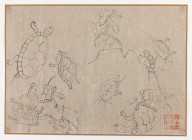
Turtle Studies
![Sensei-shō gojūmanbun no ichi chishizu [cartographic material]](https://stacks.stanford.edu/image/iiif/wm502tg3204%2Fwm502tg3204_00_0001/full/!200,200/0/default.jpg)
Sensei-shō gojūmanbun no ichi chishizu [cartographic material]
![Gohyakumanbunnoichi sorenpō yochizu [cartographic material]](https://stacks.stanford.edu/image/iiif/vz338tz0647%2Fvz338tz0647_00_0001/full/!200,200/0/default.jpg)
Gohyakumanbunnoichi sorenpō yochizu [cartographic material]
![[Carte hollandaise manuscrite de la côte orientale du Japon et de la terre de Jeso]](https://api.europeana.eu/api/v2/thumbnail-by-url.json?uri=http%3A%2F%2Fgallica.bnf.fr%2Fark%3A%2F12148%2Fbtv1b5963173g.thumbnail.jpg&type=IMAGE)
[Carte hollandaise manuscrite de la côte orientale du Japon et de la terre de Jeso]
雨雪山水図屏風

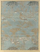
Niikawagunbungenezu
遠江国絵図

Seconde partie de la carte d'Asie contenant la Chine, et partie de la Tartarie, l'Inde au-delà du ...

General map of China and adjacent regions showing treaty ports and railroads / prepared for the Department o...
Piece

冨士裾野演習場(二万五千分1演習場図)

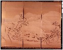
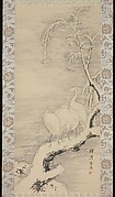
花鳥図屏風
![Winter [center right from the set Rice Farming in the Four Seasons]](https://2.api.artsmia.org/96530.jpg)
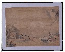
Winter [center right from the set Rice Farming in the Four Seasons]
Nijūgomanbun no ichi Papua-tō Sepikku-gawa ryūiki zu (Sheet 1)
「隅田川之景」
徒然草画帖_第18段
Hanging scroll
Piece

「西国三十三所順拝地図」

Kuniyoshi's preparatory drawings, no.39
「天川屋儀平 松本幸四郎」「重太郎 菊五郎」
Last Updated: 2020-04-17
Uploaded: 2021-09-21