
「冨士裾野

富士の裾野の野外演習(教練)
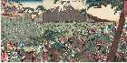
「冨士の裾野巻狩図」

『(冨士裾野) 歩兵大隊教練』
習志野演習場

習志野演習場
「高野山 苅萱道心」「冨士ノ裾野 五郎時宗」
「高野山 苅萱道心」「冨士ノ裾野 五郎時宗」
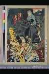
「高野山 石動丸」「冨士ノ裾野 十郎祐成」
「高野山 石動丸」「冨士ノ裾野 十郎祐成」
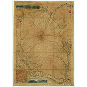
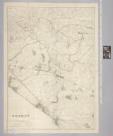
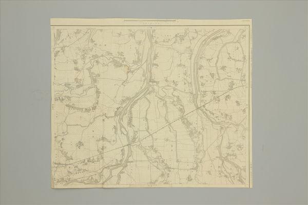
冨士山近傍(五万分一山嶽図)

「仮名手本忠臣蔵」 「八段目」「冨士の裾野 道行の場」

「冨士裾野曽我兄弟本望遂図」 「富士裾野曽我兄弟本望遂図(三枚続)」

冨士山(二万分一地形図冨士山近傍十二号)
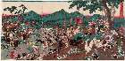
「冨士裾野牧狩におひて曽我兄弟敵工藤を」 「図」

「宇和島市全図」 9千分の1(5万分の1付)

千種演習場と幻の特攻用飛行場

〔習志野名所〕千葉県習志野 第一射撃場
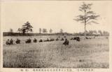
〔習志野練兵場〕陸軍士官学校歩兵生徒演習実況 〔膝射〕

①(関ヶ原 大垣 二万五千分一) ②(垂井 二万五千分一)

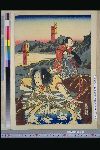
「右大将頼朝公冨士裾野牧狩 仁田忠常古猪討図」
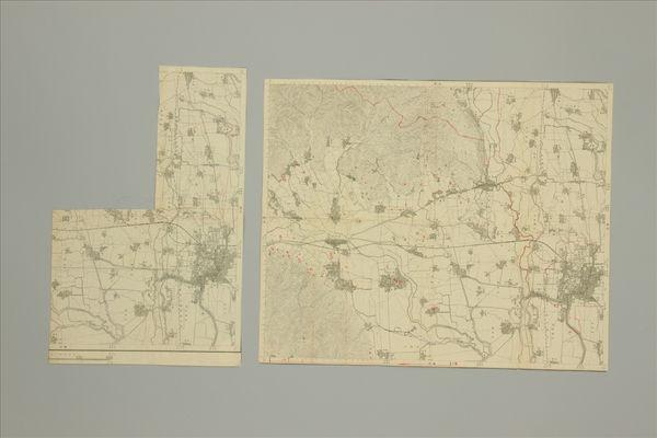
①②(大垣 二万五千分一)
(墨俣 二万五千分一)
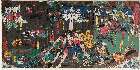
「建久四年五月二十八日冨士之裾野曽我兄弟夜討本望之図」
Piece

hanging scroll; painting

Shiina shimogou ezu shitagaki

探幽/鬼谷子図
![[Carte hollandaise manuscrite de la côte orientale du Japon et de la terre de Jeso]](https://api.europeana.eu/api/v2/thumbnail-by-url.json?uri=http%3A%2F%2Fgallica.bnf.fr%2Fark%3A%2F12148%2Fbtv1b5963173g.thumbnail.jpg&type=IMAGE)
[Carte hollandaise manuscrite de la côte orientale du Japon et de la terre de Jeso]

A Correct Map From Actual Surveys And Examinations Embracing A Portion of California Between Monte...

The Arton Trial (third plate)

(Composite of) A New Chart of The Pacific Ocean, Exhibiting The Western Coast of America, From Cap...
![Pôro ki Rômajin-sho / [Trad. par Bernard John Bettelheim][Hong-kong, 1855]; 保羅奇羅馬人書 / バーナード・ジャン・ベッ...](https://api.europeana.eu/thumbnail/v2/url.json?uri=http%3A%2F%2Fgallica.bnf.fr%2Fark%3A%2F12148%2Fbtv1b10508390n.thumbnail.jpg&type=TEXT)
Pôro ki Rômajin-sho / [Trad. par Bernard John Bettelheim][Hong-kong, 1855]; 保羅奇羅馬人書 / バーナード・ジャン・ベッ...
Denckwürdige Gesandtschafften der Ost-Indischen Geselschaft in den Vereinigten Niederländern/ an u...

「増補両面江戸図鑑」「分間江戸図」

Shinsen buki meikan 新選武器銘鑑

A New Chart of The Pacific Ocean, Exhibiting The Western Coast of America, From Cape Horn To Beeri...

Niikawagunbungenezu
Hyakuman bun no ichi Manshūkoku yochizu / Dai Nihon Teikoku Rikuchi Sokuryōbu

hanging scroll; painting

Carte Physique & Politique. : No. 16 : l'Asie

Niikawagunbungenezu

print; hanging scroll
Laurie and Whittle's new chart of the Indian and Pacific Oceans between the Cape of Good Hope, New Holland, and Japan, comprehending New Zealand, New Caledonia, New Britain, New Ireland, New Guinea,&c., Louisiade and New Georgia; also the Pelew, New Caroline, Ladrone, and Philippine Islands; &c. with the most remarkable tracks of the English, Spanish, French and Dutch navigators: and chiefly the track of the Walpole, Eastindiaman, Captn. Thos. Butler, 1794 from the Cape of Good Hope to Van Diemen's Land and, from thence to China, and the track of the Royal Admiral Captn. Henr. Bond in 1792 and 93, from the Cape to Port Jackson and China
keisaieisen

Map of Tokio
![Heron and Reeds [left of a pair of Swallow and Heron]](https://2.api.artsmia.org/37640.jpg)
Heron and Reeds [left of a pair of Swallow and Heron]
Last Updated: 2025-07-15T01:26:19
Uploaded: 2025-07-16