
An accurate Map of the British Colonies in North Ameria bordering on the River Ohio (First Appeara...
- People
- Time
- Owner Organization

A Map of the Middle British Colonies In North America First Published By Mr. Lewis Evans of Philad...

A New and Accurate Map of the Colony of Massachusets Bay, In North America from a Late Survey

A New and Accurate Map of the Colony of Massachusets Bay, In North America from a Late Survey

A New Map of North America, with the British, French, Spanish, Dutch & Danish Dominions on that gr...
British Army post office in the Western Desert, North Africa

A new and accurate map of the Empire of Japan. Laid down from the memoirs of the Portuguese and Du...
Map showing Green Islands, to the north of Biika. Several of the Japanese bases marked on the map 1 have sin...
New Zealanders on the alert during an action north of the Sangro River, Italy, World War II - Photograph tak...

A New and Accurate Map of the Empire of Japan Laid down from the Memoirs of the Portugese and Dutc...
Map of the missionary districts of north Tokyo & Kyoto : under the jurisdiction of the Bishop of Tokyo 1895
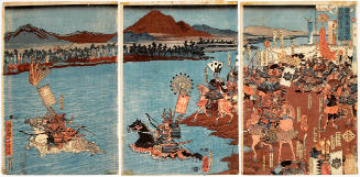
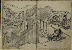
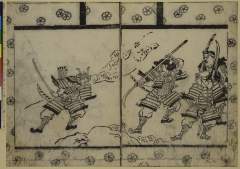
The Civil War at Uji River, Sanjo Province on the 16th Day of the First Month of 1626

A new and accurate map of the Empire of Japan : laid down from the memoirs of the Portuguese and Dutch, and ...

Boy On An Ox, Picking The First Spring Blossom
NZ soldiers on road on north side of Sangro River with snow-clad Mount Amaro in the background, Italy, World...
View of Enoshima (First Work on the First Day of the Year of the Goat, 1799)

An Accurate Chart of the World, with the New Discoveries; Also a View of the General & Coasting Tr...
Mokuboji Temple on the Sumida River, from an untitled series of Famous Places in Edo
Report on the Tendencies of the Communist Party in the North-East

THE WAR IN THE EAST; JAPANESE ARTILLERY MOVING NORTH FROM THE YALU RIVER

A New and Accurate Map of the World. Drawn from the best Surveys and regulated by Astronomical Obs...

Plans on the north-eastern coast of New Guinea

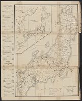
Map of the Empire of Japan in 1914

map from "Notes on the late expedition against the Russian settlements in Eastern Siberia; and of ...

A Japanese plane crashing into the sea near the stern of an American escort carrier. Accurate anti-aircraft ...
Sasakikajiwara

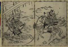
Yoshitsunemuretakamatsu
Genjihananoen
Picture Book of Gold Brocades : [volume 1]

「猿ヶ島敵討之図」

Carte Des Indes et de la Chine Dressee sur plusieurs Relations particulieres Rectifees par quelque...

A New Map of Great Tartary and China, with the adjoyning Parts of Asia, Taken from Mr. De Fer's Ma...
Yoshinotadanobu

「安芸厳島神社之図」

「秩父札所並三峰山大日向山道筋案内絵図」

Tabula Geodoborica Itinerum a Varijs in Cataium susceptorum rationem exhibens (Kircher's map of hi...

L'Empire de la Chine avec les isles du Japon. A Paris, ches Lattre, rue St. Jacq. (ca. 1800)
Visitors to Shinto Shrine
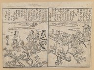
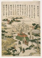
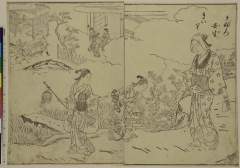
Spring Outing

La Partie Orientale De L'Asie ou Se trouvent Le Grande Empire Des Tartares Chinois et Celuy Du Iap...
Kaburo mibumairi
Asia with the islands adioyning described, the atire of the people & townes of importance, all of them newly augmented by I.S. Ano dom. 1626 / Sculptum apud Abrahamum Goos
那智濺瀑図

Carte Des Indes et de la Chine Dressee sur plusieurs Relations particulieres Rectifees par quelque...

Terza Tavola (China, Southeast Asia, Philippines and Japan)
A new map of India & China from the latest observations / by I. Senex

Shintei shiku kaisei Tōkyō meisai zenzu
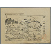
駿河国富士郡大宮国幣中社浅間神社之図
「新撰五畿内一覧 道法附」
Last Updated: 2020-04-17
Uploaded: 2021-09-21