
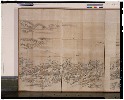
An Accurate Chart of the World, with the New Discoveries; Also a View of the General & Coasting Tr...
- People
- Time
- Owner Organization

A New & Accurate Chart of the Discoveries made by the late Capt. Js. Cook, and other distinguished...

Chart of the Discoveries to the North of Japan, in 1643, by the Dutch Ships the Kastrikum & the Br...

A New and Accurate Map of the World. Drawn from the best Surveys and regulated by Astronomical Obs...

An Outline Chart of The World Intended For The Purpose of Marking Off A Ship's Track. . . . 1883

A new and accurate map of the Empire of Japan. Laid down from the memoirs of the Portuguese and Du...
General view of New Zealand Artillery positions among the wheat fields and vineyards near Sora, Italy, World...
General view of the Volturno River showing New Zealand bivvies nearby, Italian Front, World War II - Photogr...

Dancers: View of the Shanghai New Carlton
General view of class in progress at the New Zealand Malarial School in the Volturno Valley, Italy, World Wa...

Chart of the Discoveries made in 1787, in the Seas of China and Tartary by the Boussole and Astrol...

A New and Accurate Map of the Empire of Japan Laid down from the Memoirs of the Portugese and Dutc...

Chart of Discoveries made in 1787, in the Seas of China and Tartary, by the Boussole and Astrolabe...

An accurate Map of the British Colonies in North Ameria bordering on the River Ohio (First Appeara...

View of Dancers at the New Carlton, Shanghai

A Generall Chart of the South Sea from the River of Plate to Dampiers Streights on ye Coast of New...
General view of 1 New Zealand General Hospital, Molfetta, Italy, World War II - Photograph taken by George B...
New Zealanders from New Zealand Convalescent Depot view the source of the River Jordan, Palestine, World War...
General view of New Zealand camping area in the Volturno Valley, Italy, World War II - Photograph taken by G...

A new and accurate map of the Empire of Japan : laid down from the memoirs of the Portuguese and Dutch, and ...

A New and Correct Chart of all the Known World Laid down according to Mercator's Projection

A New and Correct Chart of all the Known World Laid down according to Mercator's Projection

A New and Correct Chart of all the Known World Laid down according to Mercator's Projection

Chart of Discoveries made in 1787 In the Seas of China and Tartary between Manilla and Avateha by ...
Aerial view of the site of Camp Pahautanui, Porirua, New Zealand

Mappemonde ou Carte Reduite Des Parties Connues Du Globe Pour servir au Voyage de La Perouse …. 17...

Kasei Mōko jūmanbun no ichizu Ujimuchin
Asiae nova descriptio / auctore Jodoco Hondio

Maris Pacifici quod vulgo Mar del Zud
A new & accurate map of Asia : drawn from the most approved modern maps & charts / by Thos. Bowen ; engraved for Middletons complete system of geography

Tabula Indiae Orientalis et Regnorum Adjacentium J. Van Braam et G. onder de Linden . .

Tabula Indiae Orientalis et Regnorum Adjacentium J. Van Braam et G. onder de Linden . .
![Kaisei dai Nihon bizu [carte du Japon] / par Jikôan Mabuchi](https://api.europeana.eu/api/v2/thumbnail-by-url.json?uri=http%3A%2F%2Fgallica.bnf.fr%2Fark%3A%2F12148%2Fbtv1b53066779q.thumbnail.jpg&type=IMAGE)
Kaisei dai Nihon bizu [carte du Japon] / par Jikôan Mabuchi
片田景図(模本)
![[Map of Kyoto] [cartographic material]](https://collections.library.yale.edu/iiif/2/16683048/full/!200,200/0/default.jpg)
[Map of Kyoto] [cartographic material]
Pacific Ocean [by Sidney E. Morse]
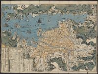
Map of Nagasaki
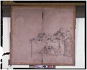
納涼図
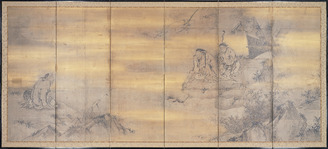
Immortals and Lofty Scholars

輿墜航海図

Jūmanbun no ichizu Chamusu oyobi Birobiddyan

Carte De La Louisiane Colonie Francaise avec le Cours du Fleuve St Louis…1757
![Sanjūmanbun no ichi Shina engan rikukai hengōzu [cartographic material]](https://stacks.stanford.edu/image/iiif/cn019rx5665%2Fcn019rx5665_00_0001/full/!200,200/0/default.jpg)
Sanjūmanbun no ichi Shina engan rikukai hengōzu [cartographic material]

Jūmanbun no ichizu Furun Buiru
A New and Correct Chart of all the Known World Laid down according to Mercator's Projection

Kaetsunousanshuugunwakeryakuezu

Pacific Islands

「祇園会十四日浮橋館幸之図」
Japanese Empire--802 M
Last Updated: 2020-04-17
Uploaded: 2021-09-21