
Strategical Map of Part of Korea and Manchuria . . . 1906
- People
- Time
- Owner Organization

Strategical map of part of Korea and Manchuria / prepared by the Second Division, General Staff (Military In...

The latest map of Manchuria, Korea, Formosa, and Saghalien

Map of Manchuria, Corea & Japan
![[Manchuria] (7 sheet US Military Information Division Map of Manchuria)](https://stacks.stanford.edu/image/iiif/yr430hp5690%2F41524/full/!200,200/0/default.jpg)
[Manchuria] (7 sheet US Military Information Division Map of Manchuria)

Korean War 1950-1953 -- Asia, North Korea, South Korea, China, Manchuria, Japan Map / Maps.com(CR)

Special war map of China, Korea, and Japan

Hokuryo, from the series Korea and Manchuria

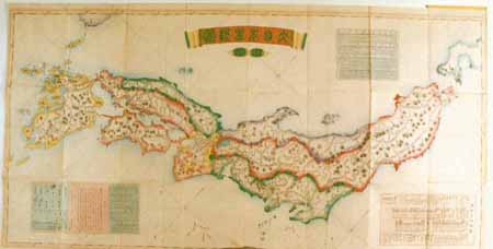
Map of Chosen (Korea)

Manchuria. Korea. Japan. (insets) (Vicinity of Osaka and Tokyo)

Bartholomew's special Map of China, Japan and Korea

Bartholomew's Special Map of China, Japan and Korea
![Map of Manchuria, Corea & Japan [cartographic material]](https://collections.library.yale.edu/iiif/2/15828540/full/!200,200/0/default.jpg)
Map of Manchuria, Corea & Japan [cartographic material]

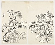
Changgyeong Palace, from the series Korea and Manchuria

Daedong Gate, from the series Korea and Manchuria
![Map of Chosen (Korea) [cartographic material].](https://stacks.stanford.edu/image/iiif/fx184cf7591%2Ffx184cf7591_0001/full/!200,200/0/default.jpg)
Map of Chosen (Korea) [cartographic material].
![[Railroads in China, Manchuria, Korea, Japan and the eastern U.S.S.R.] [cartographic material]](https://stacks.stanford.edu/image/iiif/pf710vm7134%2Fpf710vm7134_00_0001/full/!200,200/0/default.jpg)
[Railroads in China, Manchuria, Korea, Japan and the eastern U.S.S.R.] [cartographic material]
![[Map of part of Samar, Philippines, in Japanese.]](https://collections.library.yale.edu/iiif/2/15251561/full/!200,200/0/default.jpg)
[Map of part of Samar, Philippines, in Japanese.]

Market in Mukden, from the series Korea and Manchuria
![[Taisho Japanese map of the world. Taisho Japanese map of Japan and Korea]. [9 insets].](https://stacks.stanford.edu/image/iiif/yj892bp5625%2F11670000/full/!200,200/0/default.jpg)
[Taisho Japanese map of the world. Taisho Japanese map of Japan and Korea]. [9 insets].

1904 war map of Japan, Korea, and China

1904 war map of Russia and the continent of Asia

Rand, McNally & Co.'s 1904 war map of Russia and the continent of Asia

Map of Asia
Stanford's map of eastern China, Japan and Korea : the seat of war in 1894
Strategical map of part of Korea and Manchuria / prepared by the Second Division, General Staff (Military In...
Korea / prepared ... by the Army Map Service, U.S. Army

滿洲歴史地理. : 第壹巻附図 : 後漢時代満洲図(西紀二五-二二〇年)

Hyakumanbun no ichi Nanpō kōkūzu

満州地質及鑛産分布圖 : 5

習志野演習場
Manshūkoku tetsudōzu

佐賀県管内図

Kaetsunousanshuugunwakeryakuezu

China, Contains 15 Subject Provinces, including the 2 Islands of Hainan Formosa and the Tributary ...

佐賀県管内図

Japan : to illustrate the paper by Ellen Churchill Semple.

Iaponia Regnum
![[Shina] Hyakumanbunnoichi Kōkūzu](https://stacks.stanford.edu/image/iiif/sy476vd8533%2Fsy476vd8533_00_0001/full/!200,200/0/default.jpg)
[Shina] Hyakumanbunnoichi Kōkūzu
Drawing

West Coast of Korea. Approaches to Séoul : with Sir James Hall Group and Ta-Tong River
Map of Chosen (Korea)

Ishikawagunmuramurakumiwakeezu
Nihonriteizu kan

North Part of Kokai : Takushan Road and Approaches

滿洲歴史地理. : 第壹巻附図 : 前漢時代満洲図 西紀二〇二-西紀二五年
Kūchū shashin yōzu Sanman Gosen bun no ichi Bisumaruku Guntō (sheet 1)

L'Empire de la Chine d'après l'Atlas Chinois avec les Isles du Japon . .

佐賀市街図(GHQ用英語表記入)
Last Updated: 2020-04-17
Uploaded: 2021-09-21