
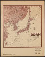
Japan : to illustrate the paper by Ellen Churchill Semple.
- Time
- Owner Organization

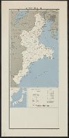
The northern Japanese Alps : to illustrate a paper by the Rev Walter Weston
Paper by the World Youth Forum
Paper by the 7th Assembly of the WFDY

Statement by Kristalina Georgieva on the EU aid to Japan

Japan: Described and Illustrated by the Japanese

Visit by Cecilia Malmström, Member of the EC, to Japan

Visit by Cecilia Malmström, Member of the EC, to Japan

Visit by Cecilia Malmström, Member of the EC, to Japan

Visit by Cecilia Malmström, Member of the EC, to Japan

Visit by Cecilia Malmström, Member of the EC, to Japan

Visit by Cecilia Malmström, Member of the EC, to Japan

Visit by Cecilia Malmström, Member of the EC, to Japan

Visit by Cecilia Malmström, Member of the EC, to Japan

Visit by Cecilia Malmström, Member of the EC, to Japan

Visit by Cecilia Malmström, Member of the EC, to Japan

Visit by Cecilia Malmström, Member of the EC, to Japan

Visit by Cecilia Malmström, Member of the EC, to Japan

Visit by Cecilia Malmström, Member of the EC, to Japan

Visit by Cecilia Malmström, Member of the EC, to Japan

Visit by Cecilia Malmström, Member of the EC, to Japan

Visit by Cecilia Malmström, Member of the EC, to Japan

Visit by Cecilia Malmström, Member of the EC, to Japan

Visit by Cecilia Malmström, Member of the EC, to Japan

Visit by Cecilia Malmström, Member of the EC, to Japan

Map of Chosen (Korea)
Dai ichi-gun shotai no ichi

Nagasaki

The Japanese empire : with central and southern Manchukuo (Manchuria)

滿洲歴史地理. : 第壹巻附図 : 隋代及唐初満洲図(西暦五八九年-六六八年)

亜細亜東部略図
Japan and adjacent regions / prepared and distributed by Army Information Branch, Army Service Forces

滿洲歴史地理. : 第壹巻附図 : 後漢時代満洲図(西紀二五-二二〇年)

General map of China and adjacent regions showing treaty ports and railroads / prepared for the Department o...

Strategical map of part of Korea and Manchuria / prepared by the Second Division, General Staff (Military In...
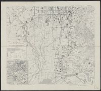
Kyoto South : Kyoto Prefecture, Honshu, Japan
![Gomanbunnoichi Rusontō zu [cartographic material]](https://stacks.stanford.edu/image/iiif/pp221kq2864%2Fpp221kq2864_00_0001/full/!200,200/0/default.jpg)
Gomanbunnoichi Rusontō zu [cartographic material]

Carte Des Missions Cathliques au Japan . . . 1898 (China and Formosa related insets)

滿洲歴史地理. : 第壹巻附図 : 後魏時代満洲図 (439-550)
Japan, Mie-ken
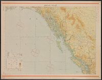
Junō--Shiyatoru / Rikuchi Sokuryōbu, Sanbō Honbu

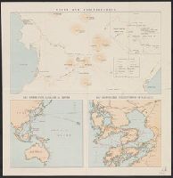
Korea, East China and Japan / The Norris Peters Co., photo-lith
![[4 maps of Luzon, Philippines, in Japanese.]](https://collections.library.yale.edu/iiif/2/15251546/full/!200,200/0/default.jpg)
[4 maps of Luzon, Philippines, in Japanese.]
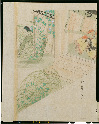
伊勢物語色紙形(模本)

滿洲歴史地理. : 第壹巻附図 : 三国時代満洲図 (220-265)・西晋時代満洲図 (265-316)

Nara, Yamada, Koyasan, & environs
Unzen and neighbourhood
Dai ni-gun no heitan : Meiji sanjūnana-nen hachi-gatsu jūichi nichi

満州地質及鑛産分布圖 : 2
Last Updated: 2021-01-30
Uploaded: 2021-07-29