
Southwest Japan (Kyūshū, Shikoku, and southwest Honshū) water works and springs [cartographic mate...
- 人物
- 時間

Southwest Japan (Kyūshū, Shikoku, and southwest Honshū), telecommunications

Southwest Japan (Kyūshū, Shikoku, and southwest Honshū) administrative divisions

Southwest Japan (Kyūshū, Shikoku, and southwest Honshū) machinery production

Southwest Japan (Kyūshū, Shikoku, and southwest Honshū) industrial concentration, 1943 [cartograph...

Southwest Japan (Kyūshū, Shikoku, and southwest Honshū), non-metallic mineral production

Southwest Japan (Kyūshū, Shikoku, and southwest Honshū), railroads and railroad facilities [cartog...

Southwest Japan (Kyūshū, Shikoku, and southwest Honshū), railroads and railroad facilities [cartog...

Southwest Japan (Kyūshū, Shikoku, and southwest Honshū), lumber and allied industries [cartographi...

Southwest Japan (Kyūshū, Shikoku, and southwest Honshū), cotton spinning, silk and rayon production

Southwest Japan (Kyūshū, Shikoku, and southwest Honshū), iron and steel industry, iron mines and d...

Southwest Japan (Kyūshū, Shikoku, and southwest Honshū) non-ferrous metals, mines and processing p...

Southwest Japan (Kyūshū, Shikoku, and southwest Honshū), railroads and railroad facilities

Southwest Japan (Kyushu, Shikoku, and Southwest Honshu) : Cities and towns (Shi) : size and functi...

Southwest Japan (Kyushu, Shikoku, and Southwest Honshu) : surpluses and deficits of food resources

Shimonoseki and Moji, Honshū and Kyūshū, Japan

Central Japan (central and northern Honshū) water supply

Asia, Japan--South Korea, Korea Strait to Tōkyō-Wan, including Shikoku and Kyūshū [electronic reso...
Japan, northeastern coast of Honshū and southern Hokkaidō [electronic resource]
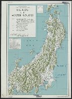
Central Japan (central and northern Honshu) : roads and water routes

Colton's Japan. Nippon, Kiusiu (Kyushu), Sikok (Shikoku), Yesso (Hokaido) and the Japanese Kuriles...
Southwest Japan (Kyūshū, Shikoku, and southwest Honshū), cotton spinning, silk and rayon production
Southwest Japan (Kyushu, Shikoku, and Southwest Honshu) : surpluses and deficits of food resources
Southwest Japan (Kyūshū, Shikoku, and southwest Honshū), railroads and railroad facilities [cartog...
Southwest Japan (Kyūshū, Shikoku, and southwest Honshū), telecommunications
Southwest Japan (Kyūshū, Shikoku, and southwest Honshū), railroads and railroad facilities [cartog...
Southwest Japan (Kyushu, Shikoku, and Southwest Honshu) : Cities and towns (Shi) : size and functi...
Southwest Japan (Kyūshū, Shikoku, and southwest Honshū), lumber and allied industries [cartographi...
Southwest Japan (Kyūshū, Shikoku, and southwest Honshū) machinery production
Southwest Japan (Kyūshū, Shikoku, and southwest Honshū), non-metallic mineral production
Southwest Japan (Kyūshū, Shikoku, and southwest Honshū) non-ferrous metals, mines and processing p...

City plan of Kōbe.
![Kōbe [cartographic material] : municipal water supply, distribution](https://stacks.stanford.edu/image/iiif/yk027jw4267%2Fyk027jw4267_00_0001/full/!200,200/0/default.jpg)
Kōbe [cartographic material] : municipal water supply, distribution
Southwest Japan (Kyūshū, Shikoku, and southwest Honshū), railroads and railroad facilities
![Kantō area [cartographic material] : highways and waterways](https://stacks.stanford.edu/image/iiif/gd204cf5107%2Fgd204cf5107_00_0001/full/!200,200/0/default.jpg)
Kantō area [cartographic material] : highways and waterways
Southwest Japan (Kyūshū, Shikoku, and southwest Honshū), iron and steel industry, iron mines and d...

Eastern Archipelago : Flores Sea. Tana Jampea and Adjacent Islands
Southwest Japan (Kyūshū, Shikoku, and southwest Honshū) administrative divisions

「名所江戸百景」 「高田姿見のはし俤の橋砂利場」
Southwest Japan (Kyūshū, Shikoku, and southwest Honshū) industrial concentration, 1943 [cartograph...
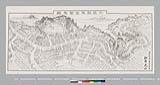
東金町鳥瞰図

Central Japan (central and northern Honshū) distribution of population
![Town plan of Sendai [cartographic material]](https://stacks.stanford.edu/image/iiif/fv573yp8495%2Ffv573yp8495_00_0001/full/!200,200/0/default.jpg)
Town plan of Sendai [cartographic material]
![東部ニューギニア「フォン」半島及「マダン」地區兵要地誌資料圖 [地図資料]](https://stacks.stanford.edu/image/iiif/ns225gy7512%2Fns225gy7512_00_0001/full/!200,200/0/default.jpg)
東部ニューギニア「フォン」半島及「マダン」地區兵要地誌資料圖 [地図資料]
![Japan, radiotelephone and radiotelegraph stations [cartographic material] : 1941](https://stacks.stanford.edu/image/iiif/pp234mp0165%2Fpp234mp0165_00_0001/full/!200,200/0/default.jpg)
Japan, radiotelephone and radiotelegraph stations [cartographic material] : 1941
最終更新日: 2020-04-17
登録日: 2021-09-21