
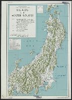
Central Japan (central and northern Honshū) water supply
- Time
- Owner Organization

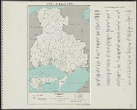
Central Japan (central and northern Honshū) distribution of population
Stanford University Libraries
Stanford Libraries SearchWorks
Central Japan :
Yale University Library
Yale University Library Digital Collections

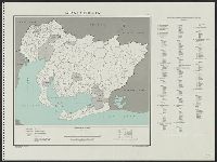
Central Japan (Central and Northern Honshū). Administrative divisions. No. 5282
Stanford University Libraries
Stanford Libraries SearchWorks

Southwest Japan (Kyūshū, Shikoku, and southwest Honshū) water works and springs [cartographic mate...
Stanford University Libraries
Stanford Libraries SearchWorks
Japan--USSR : northern territories / Central Intelligence Agency
National Library of Australia
Trove: National Library of Australia

Shimonoseki and Moji, Honshū and Kyūshū, Japan
Stanford University Libraries
Stanford Libraries SearchWorks
![Japan, northeastern coast of Honshū and southern Hokkaidō [electronic resource]](https://www.gumtree.com/static/1/resources/assets/rwd/images/orphans/a37b37d99e7cef805f354d47.noimage_thumbnail.png)
Japan, northeastern coast of Honshū and southern Hokkaidō [electronic resource]
Stanford University Libraries
Stanford Libraries SearchWorks

Ube, Yamaguchi Prefecture, Honshū, Japan
Stanford University Libraries
Stanford Libraries SearchWorks

Southwest Japan (Kyūshū, Shikoku, and southwest Honshū), telecommunications
Stanford University Libraries
Stanford Libraries SearchWorks

Southwest Japan (Kyūshū, Shikoku, and southwest Honshū), railroads and railroad facilities [cartog...
Stanford University Libraries
Stanford Libraries SearchWorks

Southwest Japan (Kyūshū, Shikoku, and southwest Honshū), railroads and railroad facilities [cartog...
Stanford University Libraries
Stanford Libraries SearchWorks

Mito, Ibaraki-ken, Honshū, Japan
Stanford University Libraries
Stanford Libraries SearchWorks

Gas and water-supply in greater Tokyo - 1928
Boston Public Library
DPLA API

Southwest Japan (Kyūshū, Shikoku, and southwest Honshū) administrative divisions
Stanford University Libraries
Stanford Libraries SearchWorks

Southwest Japan (Kyūshū, Shikoku, and southwest Honshū) machinery production
Stanford University Libraries
Stanford Libraries SearchWorks

Hiroshima, Hiroshima Prefecture, Honshū, Japan
Stanford University Libraries
Stanford Libraries SearchWorks

Sendai, Japan, Miyagi-ken, Honshū.
Stanford University Libraries
Stanford Libraries SearchWorks
Civil Affairs Guide: Water Supply and Sewage Disposal in Japan
NDL Digital Collections
NDL Digital Collections

Okegawa, Saitama Prefecture, Honshū, Japan
Stanford University Libraries
Stanford Libraries SearchWorks

Toyokawa, Aichi Prefecture, Honshū, Japan
Stanford University Libraries
Stanford Libraries SearchWorks

Toyohashi, Aichi Prefecture, Honshū, Japan
Stanford University Libraries
Stanford Libraries SearchWorks

Southwest Japan (Kyūshū, Shikoku, and southwest Honshū) industrial concentration, 1943 [cartograph...
Stanford University Libraries
Stanford Libraries SearchWorks

Southwest Japan (Kyūshū, Shikoku, and southwest Honshū), iron and steel industry, iron mines and d...
Stanford University Libraries
Stanford Libraries SearchWorks
Church on the Water, Tomamu, Hokkaido, Japan (Elevation and plan)
Museum of Modern Art, New York
The Museum of Modern Art (MoMA) Collection
Central Japan :
Yale University Library
Yale University Library Digital Collections
![Japan, radiotelephone and radiotelegraph stations [cartographic material] : 1941](https://stacks.stanford.edu/image/iiif/pp234mp0165%2Fpp234mp0165_00_0001/full/!200,200/0/default.jpg)
Japan, radiotelephone and radiotelegraph stations [cartographic material] : 1941
Stanford University Libraries
Stanford Libraries SearchWorks
Central Japan (Central and Northern Honshū). Administrative divisions. No. 5282
Stanford University Libraries
Stanford Libraries SearchWorks

Japan, spring areas
Yale University Library
Yale University Library Digital Collections

Japan, radiotelephone and radiotelegraph stations : 1941
Yale University Library
Yale University Library Digital Collections
![Tōkyō, Ōmori-ku, guide to postal districts [cartographic material] = 大森區詳細圖](https://collections.library.yale.edu/iiif/2/15511728/full/!200,200/0/default.jpg)
Tōkyō, Ōmori-ku, guide to postal districts [cartographic material] = 大森區詳細圖
Yale University Library
Yale University Library Digital Collections

Japan, Oita-ken
Yale University Library
Yale University Library Digital Collections

Japan, Miyazaki-ken.
Stanford University Libraries
Stanford Libraries SearchWorks

Hokkaidō-chō : administrative divisions
Stanford University Libraries
Stanford Libraries SearchWorks
Central Japan (central and northern Honshū) distribution of population
Stanford University Libraries
Stanford Libraries SearchWorks

The Japanese petroleum industry (map no. two)
Stanford University Libraries
Stanford Libraries SearchWorks
Hyōgo-ken
Yale University Library
Yale University Library Digital Collections
![Japan, Oita-ken [cartographic material]](https://stacks.stanford.edu/image/iiif/qg228fy6190%2Fqg228fy6190_00_0001/full/!200,200/0/default.jpg)
Japan, Oita-ken [cartographic material]
Stanford University Libraries
Stanford Libraries SearchWorks

Southwest Japan (Kyūshū, Shikoku, and southwest Honshū), railroads and railroad facilities
Yale University Library
Yale University Library Digital Collections

Saeki, Oita Prefecture. Kyushu, Japan
Stanford University Libraries
Stanford Libraries SearchWorks
Japan. Aichi-ken : administrative divisions, November 1943
Yale University Library
Yale University Library Digital Collections

Nemuro
Yale University Library
Yale University Library Digital Collections

Kagoshima-ken
Yale University Library
Yale University Library Digital Collections

Eastern Archipelago : Eastern Part of Celebes
Stanford University Libraries
Stanford Libraries SearchWorks
Okinawa, Japan, administrative divisions
National Library of Australia
Trove: National Library of Australia
![Kūchū shashin yōzu Sanman Gosen bun no ichi Bisumaruku Guntō [cartographic material]](https://stacks.stanford.edu/image/iiif/sv955fw2847%2Fsv955fw2847_00_0001/full/!200,200/0/default.jpg)
Kūchū shashin yōzu Sanman Gosen bun no ichi Bisumaruku Guntō [cartographic material]
Stanford University Libraries
Stanford Libraries SearchWorks

Southwest Japan (Kyūshū, Shikoku, and southwest Honshū), lumber and allied industries [cartographi...
Stanford University Libraries
Stanford Libraries SearchWorks

City plan of Kōbe.
Stanford University Libraries
Stanford Libraries SearchWorks
Southwest Japan (Kyūshū, Shikoku, and southwest Honshū), telecommunications
Stanford University Libraries
Stanford Libraries SearchWorks
Last Updated: 2020-04-17
Uploaded: 2021-09-21