
Politische Karte von China : Japan, Korea, China und der Mandschurei / herausgegeben von A. Scobel
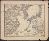
Karte von Japan & Corea

Topographische Karte von Japan (Dai Nippon)

China und Japan

China und Japan
![Karte von China und Japan den Manen D'Anville's und Klapproth's [cartographic material] / gewidmet Potsdam v...](https://collections.library.yale.edu/iiif/2/15824679/full/!200,200/0/default.jpg)
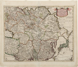
Karte von China und Japan den Manen D'Anville's und Klapproth's [cartographic material] / gewidmet Potsdam v...

Politisch-militärische Karte von Ost Asien zur Veranschaulichung der Kämpfe in China, Korea und Ja...

Verzeichnis der bedeutenden und reichhaltigen Sammlung von China- und Japan-Altertümern und Kunsts...

China und Japan: Kooperation und Rivalität

No. 69. China und Japan

Porzellan aus China und Japan

Porzellan aus China und Japan
Buddhismus und Moderne in China und Japan

Fälscherwesen in Japan und China

China (Ostl. Theil), Korea Und Japan Im Maassstabe Von 1:7.500.000. Von A Petermann. Bearbeitet vo...

Russisch-japanischer Kriegsschauplatz : karte von Ost-Asien mit spezialkarte von Korea
![China und Japan Porzellan, Möbel und Antiquitäten [...] : [vente du 28 avril 1914]; China und Japa...](https://api.europeana.eu/api/v2/thumbnail-by-url.json?uri=http%3A%2F%2Ftools.yoolib.net%2Fi%2Fs4%2Finha%2Ffiles%2F16001-17000%2F16186%2Fmedia%2F17377%2F1003_doucet_cv02799_19140428_001%2FWID800%2FHEI900.jpg&type=TEXT)
China und Japan Porzellan, Möbel und Antiquitäten [...] : [vente du 28 avril 1914]; China und Japa...
China (östlicheTheil), Korea und Japan im Massstab 1:7.500.000

Stieler's Hand-Atlas ... No. 43c. China und Japan
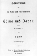
Schilderungen aus der Natur und dem Volksleben von China und Japan.
Von Tag zu Tag - Hans Kanns Reise durch China und Japan; Gespräch mit Hans Kann

China and Japan. (with) Umgegend von Peking. (with) Umgegend von Tokio. (Richard Andree. Herausgeg...
Korea, Nordost-China und Süd-Japan

Donnergötter von Taiwan, Peru und Japan

Chinesisches Reich

Tartariae Maioris sive Asiaticae Tabula . . . . Tartarium Russicam, Tartariam Sinensem et Tar4tari...

Magnae Tartariae Magni Mogolis Imperii Iaponiae et Chinae Nova Descriptio
<i>Map of Tartary</i>

A New Map of Asia from the latest Observations Most Humbly Inscrib'd to the Right Honbl. George Ea...

Neue Kriegskarte von Ost-Asien

Hitome de wakaru shina jihen to nisso kankei e chizu. (Drawn by) Eisuke Ishida. Showa 12 (1937). (...
Hitome de wakaru shina jihen to nisso kankei e chizu. (Drawn by) Eisuke Ishida. Showa 12 (1937). (...

Mandchourie Corée, Japon et côtes orientales de la chine d'après les documents russes, japonais et...

Spatiosissimum Imperium Russiae Magnae juxta recentissimas Observationes Mappa Geographica . .
![A New & Accurate Map of Asia . . . [Shows Mythical De Gama's Land!]](https://stacks.stanford.edu/image/iiif/gy686vg9722%2F30577/full/!200,200/0/default.jpg)
A New & Accurate Map of Asia . . . [Shows Mythical De Gama's Land!]

China divided into its Great Provinces, and The Isle of Japan . . . 1774
![Japan and adjacent regions of Asia and the Pacific Ocean [cartographic material] / compiled and drawn in the...](https://collections.library.yale.edu/iiif/2/15510875/full/!200,200/0/default.jpg)
Japan and adjacent regions of Asia and the Pacific Ocean [cartographic material] / compiled and drawn in the...

Carte Nouvelle de Tout L'Empire de la Grande Russie Dans L'Estat Ou Il S'Este Trouve A La Mort De ...
Estrecho de Simonoseki. H. 106a :entrada occidentral del Seto-Uchi tomados de los trabajos verific...
岐阜県新地図

Tabula Tartariae et majoris partis Regni Chinae . .

Asia

Chinese and Independent Tartary
![Nihyakugojūmanbun no ichi Tōbu Chūbu "So" ryō yochizu [cartographic material]](https://stacks.stanford.edu/image/iiif/nb222jb7845%2Fnb222jb7845_00_0001/full/!200,200/0/default.jpg)
Nihyakugojūmanbun no ichi Tōbu Chūbu "So" ryō yochizu [cartographic material]

Europa im achtzehnten Jahrhundert, von 1700 bis 1789
![Novae Insulae XXVI Nova Tabula [Rare 2nd State of first map of America]](https://stacks.stanford.edu/image/iiif/rw771xj8747%2F36978mo/full/!200,200/0/default.jpg)
Novae Insulae XXVI Nova Tabula [Rare 2nd State of first map of America]

徳島市街全図

Europa um 350 nach Christo
Last Updated:
Uploaded: 2021-07-27