Estrecho de Simonoseki. H. 106a :entrada occidentral del Seto-Uchi tomados de los trabajos verific...

![Gomanbun no ichi Chishima rettō rikukai hengōzu [cartographic material]](https://stacks.stanford.edu/image/iiif/hb691zk3905%2Fhb691zk3905_00_0001/full/!200,200/0/default.jpg)
Gomanbun no ichi Chishima rettō rikukai hengōzu [cartographic material]
Stanford University Libraries
Stanford Libraries SearchWorks
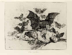
Los Desastres de la Guerra (72) <Las resultas.>
Mie Prefectural Art Museum
Mie Prefectural Art Museum Collections

日本本州北西岸能登七尾湾= Japan Honshū, N. W. coast, Nanao Bay : north bay from survey of Lieutt. K. Kimotski, I. J. N. 12th. Year of Meiji (1879), South Bay, West Bay and the Soundings at outer part of the Bays from survey of commr. K. Isono
Yoshida-South Library, Kyoto University
IIIF Discovery in Japan

painting
British Museum
British Museum Collection

Rand, McNally & Co.'s 1904 war map of Russia and the continent of Asia
Yale University Library
Yale University Library Digital Collections

Ise Bay - North :
Yale University Library
Yale University Library Digital Collections

日本北州西岸後志小樽港 = Japan Hokusyū, west coast, Shiribeshi, Otaru Kō
Yoshida-South Library, Kyoto University
IIIF Discovery in Japan

Sanmai-zuzuki Yodo-gawa tsutsumi Hachiman yo no zu (Object)
British Museum
British Museum Collection

Strategical map of part of Korea and Manchuria / prepared by the Second Division, General Staff (Military In...
Yale University Library
Yale University Library Digital Collections

Nara, Yamada, Koyasan, & environs
Yale University Library
Yale University Library Digital Collections

Itsukushima jinja no saizu zen (Object)
British Museum
British Museum Collection

Tartariae Maioris sive Asiaticae Tabula . . . . Tartarium Russicam, Tartariam Sinensem et Tar4tari...
Stanford University Libraries
Stanford Libraries SearchWorks
![Novae Insulae XVII Nova Tabula [First State!]](https://stacks.stanford.edu/image/iiif/sw590fs2648%2F23067/full/!200,200/0/default.jpg)
Novae Insulae XVII Nova Tabula [First State!]
Stanford University Libraries
Stanford Libraries SearchWorks
![Novae Insulae XVII Nova Tabula [First State!]](https://stacks.stanford.edu/image/iiif/vz186mx1354%2F22284/full/!200,200/0/default.jpg)
Novae Insulae XVII Nova Tabula [First State!]
Stanford University Libraries
Stanford Libraries SearchWorks

Mandchourie et Coree de Kharbine a Seoul de Port-Arthur a Vladivostok Traduction de la Carte d'Eta...
Stanford University Libraries
Stanford Libraries SearchWorks

Manshū jūmanbun no ichizu Chūbu Daikōanrei
Stanford University Libraries
Stanford Libraries SearchWorks

painting
British Museum
British Museum Collection
Last Updated:
Uploaded: 2021-07-27