![[Untitled Map of the Ancient World : Europe, Asia and Africa]](https://stacks.stanford.edu/image/iiif/ss295kf6573%2F37437/full/!200,200/0/default.jpg)
![[Untitled World Map Fragment]](https://stacks.stanford.edu/image/iiif/gc305gf6602%2F23256/full/!200,200/0/default.jpg)
[Untitled World Map Fragment]
![[Modern Map of the World]](https://stacks.stanford.edu/image/iiif/vc284tj9920%2F35672ll/full/!200,200/0/default.jpg)
[Modern Map of the World]

The Russian Empire, in Europe and Asia

(Pictorial map of Asia)
![[Playing card maps of of Europe and Asia and their countries]](https://collections.library.yale.edu/iiif/2/15242256/full/!200,200/0/default.jpg)
[Playing card maps of of Europe and Asia and their countries]
![[Map of East Asia]](https://stacks.stanford.edu/image/iiif/kg150vx7689%2F41423/full/!200,200/0/default.jpg)
[Map of East Asia]
Map of North Africa showing the extent of operations undertaken by the Long Range Desert Group during World ...
![[Untitled World Map] (California as an Island, etc.)](https://stacks.stanford.edu/image/iiif/wr620nw9044%2F34885gm/full/!200,200/0/default.jpg)
[Untitled World Map] (California as an Island, etc.)

A humourous diplomatic atlas of Europe and Asia - Karikatur - Mehrsprachige Landkarte - Budapest
![Bankokuzu Zen : [Complete map of the World]](https://stacks.stanford.edu/image/iiif/hd277ns8369%2Fhd277ns8369_05_0001/full/!200,200/0/default.jpg)
Bankokuzu Zen : [Complete map of the World]
![[Taisho Japanese map of the world. Taisho Japanese map of Japan and Korea]. [9 insets].](https://stacks.stanford.edu/image/iiif/yj892bp5625%2F11670000/full/!200,200/0/default.jpg)
[Taisho Japanese map of the world. Taisho Japanese map of Japan and Korea]. [9 insets].

A new map of the Chinese Empire with Japan and Korea. Map of Asia. / by Rand, McNally & Co

Up-to-date map of the world war

Ancient crater of Aso, largest in the world, Japan

Travels in Europe, Africa, and Asia, performed between the years 1770 and 1779 <v. 1>

Travels in Europe, Africa, and Asia, performed between the years 1770 and 1779 <v. 2>

Travels in Europe, Africa, and Asia, performed between the years 1770 and 1779 <v. 4>

Travels in Europe, Africa, and Asia, performed between the years 1770 and 1779 <v. 3>

Floppy Disk Game for Commodore 64: "Map of the World"
![[Manuscript Wall Map of the World].](https://stacks.stanford.edu/image/iiif/fg733xj4169%2F10130001/full/!200,200/0/default.jpg)
[Manuscript Wall Map of the World].

Most of the world : the peoples of Africa, Latin America, and the east today / edited by Ralph Linton
Relief map of Japan and South East Asia from Camouflage Unit, AHQ, World War II
![[Chinese Text with Image of a Map of the World]](https://api.europeana.eu/api/v2/thumbnail-by-url.json?uri=http%3A%2F%2Fmedia.iwm.org.uk%2Fiwm%2FmediaLib%2F191%2Fmedia-191923%2Flarge.jpg&type=IMAGE)
[Chinese Text with Image of a Map of the World]

9 Map manuscript Atlas of Asia with illustrations

Christianographie (Ancient World)

Tabula Geodoborica Itinerum a Varijs in Cataium susceptorum rationem exhibens (Kircher's map of hi...

India Orientalis . . . 1600

A New Map of Great Tartary and China, with the adjoyning Parts of Asia, Taken from Mr. De Fer's Ma...

A New Map of Great Tartary and China, with the adjoyning Parts of Asia, Taken from Mr. De Fer's Ma...

Descripcao nova, e exacta dos Reynos, e Provincias do Japao
![[Southeast Asia, China & India]](https://stacks.stanford.edu/image/iiif/jj467gk2095%2F0171gh/full/!200,200/0/default.jpg)
[Southeast Asia, China & India]

Exacta et accurata delineatio cum orarum maritimarum tum etiam locotum terrestrium quae in regioni...

Iaponiae nova descriptio

Isola del Giapone e Penisola di Corea. .

Descripcao nova, e exacta dos Reynos, e Provincias do Japao

Das Chinesische Reich mit den Schutz-Staaten, und Japan: entw. u. gez. v. C.G R.(eichard) 1826. Ge...

Maris Pacifici Vulgo Mar del zur
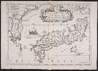
Isola del Giapone e penisola de Corea / Vincenzo Coronelli

Ost-Indien
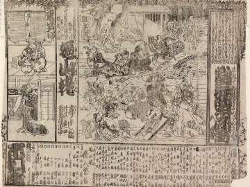
当三升四谷聞書、嫗山姥

Descriptio Hydrographica accomodata ad Battavorum navagatione Javam Insula Indiae Orientalis . . ....

India quae Orientalis dicitur et Insulae Adiacentes

Carte des Indes Orientales . . . 1677

Imperium Japonicum per regiones digestum sex et sexaginta atque ex ipsorum japonensium mappis desc...

Carte de L'Asie selon le auteurs Anciens enrichie de Remarques Historiques sur les changemens qui ...

(春の神のけそう)

A Map of the East-Indies and the Adjacent Countries; with the Settlements, Factories and Territori...

「東山八景」 「霊山秋月」「円山夕照」「清水寺帰帆」「長楽寺晩鐘」「白川落雁」「五条橋晴嵐」「比叡山暮雪」「祇園夜雨」
最終更新日: 2020-04-17
登録日: 2021-09-21