
(Pictorial map of Asia)
- People
- Time
- Owner Organization
![[Map of East Asia]](https://stacks.stanford.edu/image/iiif/kg150vx7689%2F41423/full/!200,200/0/default.jpg)
[Map of East Asia]
Stanford University Libraries
Stanford Libraries SearchWorks

9 Map manuscript Atlas of Asia with illustrations
Stanford University Libraries
Stanford Libraries SearchWorks
![[Russian Map of Northeastern Asia, Japan, Korea, China, Alaska, etc.] ( Summary map of hydrographi...](https://stacks.stanford.edu/image/iiif/pj697kr2558%2F35405/full/!200,200/0/default.jpg)
[Russian Map of Northeastern Asia, Japan, Korea, China, Alaska, etc.] ( Summary map of hydrographi...
Stanford University Libraries
Stanford Libraries SearchWorks

Political Map Asia Japan / Maps.com(CR)
National Library of Australia
Trove: National Library of Australia
![[Untitled Map of the Ancient World : Europe, Asia and Africa]](https://stacks.stanford.edu/image/iiif/ss295kf6573%2F37437/full/!200,200/0/default.jpg)
[Untitled Map of the Ancient World : Europe, Asia and Africa]
Stanford University Libraries
Stanford Libraries SearchWorks
USGS OFR 98-769: Geographic base map of northeast Asia
Stanford University Libraries
Stanford Libraries SearchWorks

India Extrema XIX Nova Tabula (1st Printed Map of Asia)
Stanford University Libraries
Stanford Libraries SearchWorks
Map of Japan
Univerzita Karlova. Mapová sbírka
Europeana API
![[Map of Kyoto]](https://collections.library.yale.edu/iiif/2/15510884/full/!200,200/0/default.jpg)
[Map of Kyoto]
Yale University Library
Yale University Library Digital Collections
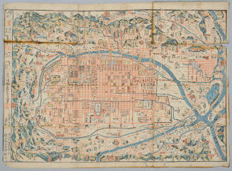
Map of Kyoto
Honolulu Museum of Art
Honolulu Museum of Art Collection
[Map of Kyoto]
National Library of Australia
Trove: National Library of Australia

Map of Japan
Boston Public Library
DPLA API

Map of Japan
Stanford University Libraries
Stanford Libraries SearchWorks
Map of Niigate
Yale University Library
Yale University Library Digital Collections
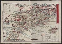
![[Map of China]](https://collections.library.yale.edu/iiif/2/16189150/full/!200,200/0/default.jpg)
[Map of China]
Yale University Library
Yale University Library Digital Collections

Map of Kyoto
Philadelphia Museum of Art
Philadelphia Museum of Art collection

Map of Japan
Library of Congress
Digital Collections, Library of Congress

To the Right Honorable William Lord Cowper Lord High Chancellor of Great Britain This Map of Asia ...
Stanford University Libraries
Stanford Libraries SearchWorks

To the Right Honorable William Lord Cowper Lord High Chancellor of Great Britain This Map of Asia ...
Stanford University Libraries
Stanford Libraries SearchWorks

To the Right Honorable William Lord Cowper Lord High Chancellor of Great Britain This Map of Asia ...
Stanford University Libraries
Stanford Libraries SearchWorks

To the Right Honorable William Lord Cowper Lord High Chancellor of Great Britain This Map of Asia ...
Stanford University Libraries
Stanford Libraries SearchWorks

Map of Asia Showing its Gt. Political Divisions and...Routes of Trade between London & India, Chin...
Stanford University Libraries
Stanford Libraries SearchWorks

Map of Asia Showing its Gt. Political Divisions and...Routes of Trade between London & India, Chin...
Stanford University Libraries
Stanford Libraries SearchWorks

Map of Asia showing its gt. political divisions, and also various routes of travel between London ...
Stanford University Libraries
Stanford Libraries SearchWorks

Sakananohanjimono
Nationaal Museum van Wereldculturen (Rijksmuseum Volkenkunde, Leiden)
ARC Ukiyo-e Portal Database

Ryuukou tako no asobi
British Museum
ARC Ukiyo-e Portal Database
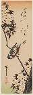
「(山桜に四十雀)」
Museum of Fine Arts, Boston
ARC Ukiyo-e Portal Database
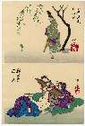
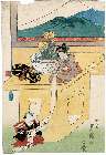
「(芳年略画)小野道風見蛙図猫活男婦志」
Museum of Fine Arts, Boston
ARC Ukiyo-e Portal Database
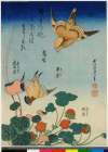
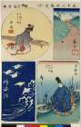
「鵙」「翠雀」「蛇苺」「虎耳草」
British Museum
ARC Ukiyo-e Portal Database

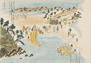
四国八十八ヶ所 遍路道中図
Tokushima Prefectural Archives
ADEAC: A System of Digitalization and Exhibition for Archive Collections
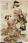
「岡本屋内 重里枝」「おげん」
British Museum
ARC Ukiyo-e Portal Database
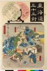
「東海道五十三対」 「見附」「膝栗毛滑稽」「喜多八」「十吉」「弥二郎兵衛」
British Museum
ARC Ukiyo-e Portal Database
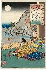
「百人一首之内」 「柿本人丸(「かきのもとのひとまろ」)」
Museum of Fine Arts, Boston
ARC Ukiyo-e Portal Database
夢の浮橋 第五十七 5月2日
Sakata City Koukyuu-bunko Museum
ADEAC: A System of Digitalization and Exhibition for Archive Collections

Exacta et accurata delineatio cùm orarum maritimarum tùm etjam locorum terrestrium quæ in regionib...
Stanford University Libraries
Stanford Libraries SearchWorks
「牛若丸 沢村国太郎」
RHAM
ARC Ukiyo-e Portal Database

「金沢八景」 「七」「野島夕照」
Art Institute of Chicago
ARC Ukiyo-e Portal Database
「(三宝・富士の掛物」 「有卦絵)」
Museum of Fine Arts, Boston
ARC Ukiyo-e Portal Database
「琴の組哥つくし」 「心つくし」
Museum of Fine Arts, Boston
ARC Ukiyo-e Portal Database
「五十三次張交」 「十」「藤川」「岡崎」「池鯉鮒」「鳴海」
British Museum
ARC Ukiyo-e Portal Database
「うすぐも」「千崎弥五郎」
British Museum
ARC Ukiyo-e Portal Database
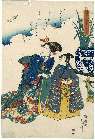
「本朝連」 「本朝廿四孝」
RHAM
ARC Ukiyo-e Portal Database
Last Updated: 2020-04-17
Uploaded: 2021-09-21