
Tabula Geodoborica Itinerum a Varijs in Cataium susceptorum rationem exhibens (Kircher's map of hi...
- People
- Time
- Owner Organization

Tabula Geodoborica Itinerum a Varijs in Cataium susceptorum rationem exhibens

India Extrema XIX Nova Tabula (1st Printed Map of Asia)

India Extrema XIX Nova Tabula (1st Printed Map of Asia)

India Extrema XIX Nova Tabula (1st Printed Map of Asia)
![Novae Insulae XXVI Nova Tabula [1st Map of the continent of America]](https://stacks.stanford.edu/image/iiif/wq175sv4465%2F28899/full/!200,200/0/default.jpg)
Novae Insulae XXVI Nova Tabula [1st Map of the continent of America]
![Novae Insulae XXVI Nova Tabula [1st Map of the continent of America]](https://stacks.stanford.edu/image/iiif/wy766vv8554%2F34123/full/!200,200/0/default.jpg)
Novae Insulae XXVI Nova Tabula [1st Map of the continent of America]
![Novae Insulae XXVI Nova Tabula [Rare 2nd State of first map of America]](https://stacks.stanford.edu/image/iiif/xn156qt5007%2F41680/full/!200,200/0/default.jpg)
Novae Insulae XXVI Nova Tabula [Rare 2nd State of first map of America]
![Novae Insulae XXVI Nova Tabula [Rare 2nd State of first map of America]](https://stacks.stanford.edu/image/iiif/rw771xj8747%2F36978mo/full/!200,200/0/default.jpg)
Novae Insulae XXVI Nova Tabula [Rare 2nd State of first map of America]
![Novae Insulae XXVI Nova Tabula [Rare 2nd State of first map of the continent of America]](https://stacks.stanford.edu/image/iiif/bt650xz6080%2F37058dr/full/!200,200/0/default.jpg)
Novae Insulae XXVI Nova Tabula [Rare 2nd State of first map of the continent of America]
![Novae Insulae XXVI Nova Tabula [Rare 2nd State of first map of the continent of America]](https://stacks.stanford.edu/image/iiif/kx205tn7925%2F35102/full/!200,200/0/default.jpg)
Novae Insulae XXVI Nova Tabula [Rare 2nd State of first map of the continent of America]

Tabula novarum insularum, quas Diversis respectibus Occidentales & Indianas uocant. [1st Map of th...

Tabula novarum insularum, quas Diversis respectibus Occidentales & Indianas uocant. [1st Map of th...
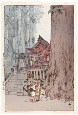
A Misty Day in Nikko (Nikkō Kiri no Hi)
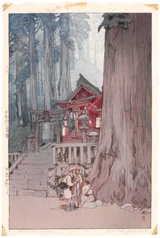
A Misty Day in Nikko (Nikkō Kiri no Hi)
![[Map of Marinduque, Philippines, in Japanese.]](https://collections.library.yale.edu/iiif/2/15251559/full/!200,200/0/default.jpg)
[Map of Marinduque, Philippines, in Japanese.]

MAP OF THE WORLD IN HEMISPHERES
![[Map of part of Samar, Philippines, in Japanese.]](https://collections.library.yale.edu/iiif/2/15251561/full/!200,200/0/default.jpg)
[Map of part of Samar, Philippines, in Japanese.]

Map of the Empire of Japan in 1914

A New and Accurate Map of the Colony of Massachusets Bay, In North America from a Late Survey

A New and Accurate Map of the Colony of Massachusets Bay, In North America from a Late Survey

A Map of Marco Polo's Voyages & Travels in the 13th Century trhough a great Part of Asia, all Tart...

【14 Days in INDIA and CEYLON 1959】The story of a boy and map

A new map of the world (There will be a cycle change of this globe in near future). Copyright 1938...
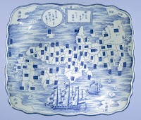
Dish with a map of Japan and inscription

A New Map of Great Tartary and China, with the adjoyning Parts of Asia, Taken from Mr. De Fer's Ma...
![[Untitled Map of the Ancient World : Europe, Asia and Africa]](https://stacks.stanford.edu/image/iiif/ss295kf6573%2F37437/full/!200,200/0/default.jpg)
[Untitled Map of the Ancient World : Europe, Asia and Africa]
Tabula Geodoborica Itinerum a Varijs in Cataium susceptorum rationem exhibens

India quae Orientalis dicitur et Insulae Adiacentes

Australia - West Coast. Shark Bay

Asia Noviter Delineata

Isola del Giapone e Penisola di Corea. .

Chart Prepared By James B. Moore, To Accompany His Memorial To Congress Respecting the subject of ...

Descripcao nova, e exacta dos Reynos, e Provincias do Japao

Carte de l'isle de Ieso et de ses environs pour servir à concilier les différentes idées que l'on ...

Imperium Sinicum Quindecupartitum

Iaponiae nova descriptio
A new map of India & China from the latest observations / by I. Senex

Descripcao nova, e exacta dos Reynos, e Provincias do Japao

A New and Correct Chart of all the Known World Laid down according to Mercator's Projection

Imperii Sinarum Nova Descriptio
A new & accurate map of Asia : drawn from the most approved modern maps & charts / by Thos. Bowen ; engraved for Middletons complete system of geography

Tartarie Chinoise, Roy, De Coree et Isles Du Japon
Empire of Japan / published under the superintendence of the Society for the Diffusion of Useful Knowledge

Tartarie Chinoise, Roy, De Coree et Isles Du Japon

Das Chinesische Reich mit den Schutz-Staaten, und Japan: entw. u. gez. v. C.G R.(eichard) 1826. Ge...

Carte des Isles du Japon et la Presqu Isle de Coree Avec les Costes de la Chine. Depuis Pekin Jusqu'a Canton...
![[Highway map of the Tokyo region].](https://stacks.stanford.edu/image/iiif/gm158cc8245%2Fgm158cc8245_0001/full/!200,200/0/default.jpg)
[Highway map of the Tokyo region].
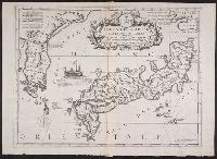
Isola del Giapone e penisola de Corea / Vincenzo Coronelli
Last Updated: 2020-04-17
Uploaded: 2021-09-21