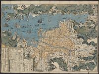
Map of Nagasaki
- Time
- Owner Organization

Map of Nagasaki (Hizen Nagasaki zu)
![[Shinkan Nagasaki No Zu. (Newly engraved Map of Nagasaki)]](https://collections.library.yale.edu/iiif/2/15823940/full/!200,200/0/default.jpg)
[Shinkan Nagasaki No Zu. (Newly engraved Map of Nagasaki)]

karta, Kyushu, Nagasaki, Karta, map@eng

Hill of Nagasaki

Nagasaki Kónai Zendu (plan du port de Nagasaki.)

A map of the city of Nagasaki, and of the adjacent country; Sorts of money current in the Japanese Empire

Map of Northern Japan. Map of Southern Japan

Nagasaki shigai zenzu = The map of nagasaki city. Kiushiu. Japan

Map of Tokio

Map of Japan
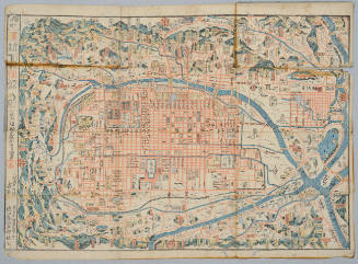
Map of Kyoto
[Map of Kyoto]
![[Map of Kyoto]](https://collections.library.yale.edu/iiif/2/15510884/full/!200,200/0/default.jpg)
[Map of Kyoto]

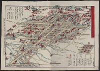
Map of Japan
Map of Niigate
![[Map of China]](https://collections.library.yale.edu/iiif/2/16189150/full/!200,200/0/default.jpg)
[Map of China]

Map of Kyoto
Map of Japan

Map of Japan
Map of Nikko
Map of Japan
Map of Japan
Map of Tokyo
![[Map of Kyoto]](https://collections.library.yale.edu/iiif/2/15510886/full/!200,200/0/default.jpg)
[Map of Kyoto]

Bunsei kaisei Oedo ōezu : zen

An Accurate Chart of the World, with the New Discoveries; Also a View of the General & Coasting Tr...

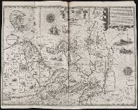
Tabula Indiae Orientalis et Regnorum Adjacentium J. Van Braam et G. onder de Linden . .

Carte De La Louisiane Colonie Francaise avec le Cours du Fleuve St Louis…1757

Tabula Indiae Orientalis et Regnorum Adjacentium J. Van Braam et G. onder de Linden . .
Pas-caert van't Oostelyckste deel van Oost Indien : met alle de Eylanden daer onder gelegen, van Cabo Comorin tot aen Japan / by Hendrick Doncker Boekverkooper en Graadbooghmaacker Inde Nieuwbrughsteegh

Charts, etc

Tartariae Imperium
「太閤五妻洛東遊観之図」 「か那殿」「三條殿」「石田三成」

Exacta & accurata delineatio cum orarum maritimarum tum etiam locorum terrestrium quae in regionibus China, ...

Exacta & accurata delineatio cum orarum maritimarum tum etiam locorum terrestrium quae in regionibus China, ...
Exacta & accurata delineatio cum orarum maritimarum ..

東亞大陸圖 : 二百五十万分一

Kasei Mōko jūmanbun no ichizu Ujimuchin

中支方面概見圖

Kokusenyakassen、mayoinokumoironinarukami、natsumatsurinaniwakagami
Asia with the islands adioyning described, the atire of the people & townes of importance, all of them newly augmented by I.S. Ano dom. 1626 / Sculptum apud Abrahamum Goos

「吉見八景」

Seconde Partie De la Carte D'Asie Contenant La Chine et partie de la Tartarie, L'Inde au dela du G...
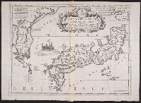
Isola del Giapone e penisola de Corea / Vincenzo Coronelli

「肥前長崎丸山」

「安芸厳島神社之図」

Karta Aziatskoi Rossii i smezhnykhi s neiu vladenii : S ukazanem puti sldovaniia Gosudaria Imperat...
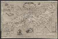
Nvova descrittione del Giappone
Last Updated: 2021-01-30
Uploaded: 2021-07-29