
A new and accurate map of the Empire of Japan : laid down from the memoirs of the Portuguese and Dutch, and ...
- People
- Time
- Owner Organization

A new and accurate map of the Empire of Japan. Laid down from the memoirs of the Portuguese and Du...

A New and Accurate Map of the Empire of Japan Laid down from the Memoirs of the Portugese and Dutc...
Map showing Pelew Island, immediately north of Dutch New Guinea, and Dili, in Portuguese Timor, between whic...

A New and Accurate Map of the World. Drawn from the best Surveys and regulated by Astronomical Obs...

Map of the Empire of Japan

A New and Accurate Map of the Colony of Massachusets Bay, In North America from a Late Survey

A New and Accurate Map of the Colony of Massachusets Bay, In North America from a Late Survey
![Japan [electronic resource] : memoirs of a secret empire](https://www.gumtree.com/static/1/resources/assets/rwd/images/orphans/a37b37d99e7cef805f354d47.noimage_thumbnail.png)
Japan [electronic resource] : memoirs of a secret empire

Map of Asia

A New and Correct Chart of all the Known World Laid down according to Mercator's Projection

A New and Correct Chart of all the Known World Laid down according to Mercator's Projection

A New and Correct Chart of all the Known World Laid down according to Mercator's Projection

Map of the Empire of Japan in 1914

The hall of hundred mats, where the Princes of the Empire and the Dutch Ambassadors are admitted to an audie...
Stanford's map of the empires of China and Japan : with the adjacent parts of the Russian Empire, ...
1 1/2 sen Map of the Empire of Japan

Geological map of the Japanese Empire on the scale of 1:1,000,000

A New & Accurate Chart of the Discoveries made by the late Capt. Js. Cook, and other distinguished...
Map of the Great Japanese Empire (Dainihon Kokugun Yochi Zenzu)
A new chart of the Indian and Pacific Oceans between the Cape of Good Hope, New Holland and Japan : comprehending New Zealand, New Caledonia, New Britain, New Ireland, New Guinea &c., also the New Caroline, Ladrone and Philippine Islands : with the tracks of the English, French, Spanish and Dutch discoverers

A map of the city of Nagasaki, and of the adjacent country; Sorts of money current in the Japanese Empire
Tables for estimating the laid down cost of China and Japan silk in Lyons, and Japan tea and silk ...

An accurate Map of the British Colonies in North Ameria bordering on the River Ohio (First Appeara...

A New Map of North America, with the British, French, Spanish, Dutch & Danish Dominions on that gr...
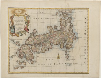
<i>New and Accurate Map of the Empire of Japan</i>
A New and Accurate Map of the Empire of Japan Laid down from the Memoirs of the Portugese and Dutc...

Korea, Nordost-China und Süd-Japan / Carl Flemming

An Improved Map of the United States By Shelton & Kensett

China, Contains 15 Subject Provinces, including the 2 Islands of Hainan Formosa and the Tributary ...

Asiae Nova Delineatio . .

Greece in the fifth century B.C

Charte Von America nach astronomischen Bestimmungen und den neuesten Charten entworfen von .L. Gus...
The Empire of Japan divided into seven principal parts and subdivided into sixty six kingdoms : wi...

Map of Northern Japan. Map of Southern Japan

(Australia and Indian Ocean) Carte des Costes de L'Asie sur L'ocean Contenant les Bancs Isles et C...
Kaart van Oost-Azië / J. Wackie

北海道地質鑛産圖

「新板植木つくし」

Empire of Japan ... Published under the Supervision of the Society for the Diffusion of Useful Kno...

Carte Du Kamtchatka . .

Carte de L'Asie selon le auteurs Anciens enrichie de Remarques Historiques sur les changemens qui ...

Atlantis Insula
Χάρτης της Ιαπωνίας

滿洲歴史地理. : 第壹巻附図 : 三国時代満洲図 (220-265)・西晋時代満洲図 (265-316)
「葉宇多虎の巻」 「しのぶ恋じのかへうた」

L'Amerique Septentrionale & Meridionale divisee en ses principales parties . .

Carte des Indes, de la Chine & des Iles de Sumatra, Java &c.
![Enjoying the Doll Festival: Women of the Bunkyū Era [1861-64], series Thirty-six Elegant Selections](https://honolulu.emuseum.com/internal/media/dispatcher/92098/thumbnail)
Enjoying the Doll Festival: Women of the Bunkyū Era [1861-64], series Thirty-six Elegant Selections
Last Updated: 2021-01-30
Uploaded: 2021-07-29