Japan-China War, 1894-5
- Time
- Owner Organization
![China and Japan [cartographic material]](https://collections.library.yale.edu/iiif/2/15828553/full/!200,200/0/default.jpg)
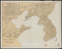
China and Japan [cartographic material]
Yale University Library
Yale University Library Digital Collections
![Government railroads of Japan [cartographic material].](https://stacks.stanford.edu/image/iiif/kn953gw3179%2Fkn953gw3179_0001/full/!200,200/0/default.jpg)
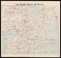
Government railroads of Japan [cartographic material].
Stanford University Libraries
Stanford Libraries SearchWorks
![Map of Manchuria, Corea & Japan [cartographic material]](https://collections.library.yale.edu/iiif/2/15828540/full/!200,200/0/default.jpg)
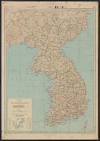
Map of Manchuria, Corea & Japan [cartographic material]
Yale University Library
Yale University Library Digital Collections
Stanford's map of eastern China, Japan and Korea : the seat of war in 1894
National Library of Australia
Trove: National Library of Australia
![China and Japan [cartographic material] / compiled from G.S.G.S. 4065 and 2957](https://collections.library.yale.edu/iiif/2/15510764/full/!200,200/0/default.jpg)
China and Japan [cartographic material] / compiled from G.S.G.S. 4065 and 2957
Yale University Library
Yale University Library Digital Collections
![Kure [cartographic material] : plan of port and naval establishments](https://stacks.stanford.edu/image/iiif/rk636yd7844%2Frk636yd7844_0001/full/!200,200/0/default.jpg)
Kure [cartographic material] : plan of port and naval establishments
Stanford University Libraries
Stanford Libraries SearchWorks
MAP, OF THE SEAT OF WAR BETWEEN CHINA AND JAPAN; (Auckland Star, 22 September 1894)
National Library of New Zealand
DigitalNZ New Zealand API
![Japan, radiotelephone and radiotelegraph stations [cartographic material] : 1941](https://stacks.stanford.edu/image/iiif/pp234mp0165%2Fpp234mp0165_00_0001/full/!200,200/0/default.jpg)
Japan, radiotelephone and radiotelegraph stations [cartographic material] : 1941
Stanford University Libraries
Stanford Libraries SearchWorks
![Japanese prisoner of war camps, during World War II, 1941-1945 [cartographic material] : known loc...](https://stacks.stanford.edu/image/iiif/zg928bt5514%2Fzg928bt5514_00_0001/full/!200,200/0/default.jpg)
Japanese prisoner of war camps, during World War II, 1941-1945 [cartographic material] : known loc...
Stanford University Libraries
Stanford Libraries SearchWorks

Album of the Japan-China war 1
Rijksmuseum
Rikijmuseum API

Album of the Japan-China War 2
Rijksmuseum
Rikijmuseum API

The Japanese naval base of operations in the Yellow Sea
Rijksmuseum
Rikijmuseum API

Special war map of China, Korea, and Japan
Stanford University Libraries
Stanford Libraries SearchWorks
Der Krieg zwischen China und Japan 1894/95. 3 Theil, Waffenstillstand, operationen gegen Formosa u...
Jagiellońska Library Cyfrowa
Europeana API
China Divided into its Great Provinces and the Isles of Japan [Material cartográfico]
Biblioteca Nacional de España
Europeana API

God of War, Our Naval Commander Hirose Takeo
Minneapolis Institute of Arts
Minneapolis Institute of Art API
God of War, Our Naval Commander Hirose Takeo
Minneapolis Institute of Arts
Minneapolis Institute of Art API
![Far East, Japanese occupied area, major railroads [cartographic material] / Board of Economic Warfare, Enemy...](https://collections.library.yale.edu/iiif/2/15510697/full/!200,200/0/default.jpg)
Far East, Japanese occupied area, major railroads [cartographic material] / Board of Economic Warfare, Enemy...
Yale University Library
Yale University Library Digital Collections
![Japan and adjacent regions of Asia and the Pacific Ocean [cartographic material] / compiled and drawn in the...](https://collections.library.yale.edu/iiif/2/15510875/full/!200,200/0/default.jpg)
Japan and adjacent regions of Asia and the Pacific Ocean [cartographic material] / compiled and drawn in the...
Yale University Library
Yale University Library Digital Collections
![Japan and adjacent regions of Asia and the Pacific Ocean [cartographic material] / compiled and drawn in the...](https://collections.library.yale.edu/iiif/2/15509964/full/!200,200/0/default.jpg)
Japan and adjacent regions of Asia and the Pacific Ocean [cartographic material] / compiled and drawn in the...
Yale University Library
Yale University Library Digital Collections
U.S. Office of War Information Photo, Burning enemy vessels and American cruisers and destroyers of the Thir...
National Library of New Zealand
DigitalNZ New Zealand API
The flight of the Lapwing, a naval officer's jottings in China, Formosa and Japan
オクスフォード大学ボドリアン図書館サービス
Europeana API

1904 war map of Japan, Korea, and China
Yale University Library
Yale University Library Digital Collections

1904 war map of Russia and the continent of Asia
Yale University Library
Yale University Library Digital Collections

Rand, McNally & Co.'s 1904 war map of Russia and the continent of Asia
Yale University Library
Yale University Library Digital Collections

Strategical map of part of Korea and Manchuria / prepared by the Second Division, General Staff (Military In...
Yale University Library
Yale University Library Digital Collections
Estrecho de Simonoseki. H. 106a :entrada occidentral del Seto-Uchi tomados de los trabajos verific...
Biblioteca Nacional de España
Europeana API

Tartariae Maioris sive Asiaticae Tabula . . . . Tartarium Russicam, Tartariam Sinensem et Tar4tari...
Stanford University Libraries
Stanford Libraries SearchWorks
![Indo oyobi Seia [cartographic material] : Roppyakmanbun no ichi](https://stacks.stanford.edu/image/iiif/dx650yf2686%2Fdx650yf2686_00_0001/full/!200,200/0/default.jpg)
Indo oyobi Seia [cartographic material] : Roppyakmanbun no ichi
Stanford University Libraries
Stanford Libraries SearchWorks

General map of China and adjacent regions showing treaty ports and railroads / prepared for the Department o...
Yale University Library
Yale University Library Digital Collections
Japan road map 1:1,000,000. sheet 4, Korea / prepared under the direction of the Chief of Engineers, U.S. Ar...
Yale University Library
Yale University Library Digital Collections

Nara, Yamada, Koyasan, & environs
Yale University Library
Yale University Library Digital Collections
Nara, Yamada, Koyasan, & environs
Yale University Library
Yale University Library Digital Collections
Edomeishoshijuuhakkeikameidotenjin
Museum of Fine Arts, Boston
ARC Ukiyo-e Portal Database
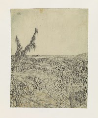
Landscape with a Plateau, a River in the Distance
Rijksmuseum
Europeana API

Nagasaki
Yale University Library
Yale University Library Digital Collections
Paper Nautilus
Harvard Art Museums
Harvard Art Museums API
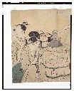
台所
Tokyo National Museum
ARC Ukiyo-e Portal Database

Map of Asia
Yale University Library
Yale University Library Digital Collections

Ise Bay - North :
Yale University Library
Yale University Library Digital Collections
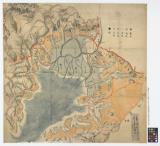
![[雲陽十郡絵図]](https://da.lib.shimane-u.ac.jp/image/open/2109987/1.tif/full/200,/0/default.jpg)
[雲陽十郡絵図]
Shimane University Library Digital Archive Collection
IIIF Discovery in Japan
浜名湖津波絵図(その2)津波の去った泥田の図
個人蔵
ADEAC: A System of Digitalization and Exhibition for Archive Collections
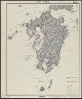
Kyushu
Yale University Library
Yale University Library Digital Collections

大日本帝國西南部地形圖
Yoshida-South Library, Kyoto University
IIIF Discovery in Japan
Fuji from Behind (Ura Fuji): Detached page from One Hundred Views of Mount Fuji (Fugaku hyakkei) Vol. 1
Harvard Art Museums
Harvard Art Museums API

阿波郡土成村絵図
Tokushima Prefectural Library
ADEAC: A System of Digitalization and Exhibition for Archive Collections

The Japanese empire : with central and southern Manchukuo (Manchuria)
Yale University Library
Yale University Library Digital Collections
![Saint-François d'Assise : [estampe] / gypsographie Pierre Roche](https://api.europeana.eu/thumbnail/v2/url.json?uri=https%3A%2F%2Fgallica.bnf.fr%2Fiiif%2Fark%3A%2F12148%2Fbtv1b10500484n%2Ff1%2Ffull%2F512%2C%2F0%2Fnative.jpg&type=IMAGE)
Saint-François d'Assise : [estampe] / gypsographie Pierre Roche
Bibliothèque nationale de France
Europeana API
Last Updated: 2021-01-30
Uploaded: 2021-07-29