![[Map of part of Samar, Philippines, in Japanese.]](https://collections.library.yale.edu/iiif/2/15251561/full/!200,200/0/default.jpg)
[Map of part of Samar, Philippines, in Japanese.]
- Time
- Owner Organization
![[Map of Marinduque, Philippines, in Japanese.]](https://collections.library.yale.edu/iiif/2/15251559/full/!200,200/0/default.jpg)
[Map of Marinduque, Philippines, in Japanese.]
Yale University Library
Yale University Library Digital Collections
![[4 maps of Luzon, Philippines, in Japanese.]](https://collections.library.yale.edu/iiif/2/15251546/full/!200,200/0/default.jpg)
[4 maps of Luzon, Philippines, in Japanese.]
Yale University Library
Yale University Library Digital Collections
![[3 maps of Leyte Island, Philippines, in Japanese.]](https://collections.library.yale.edu/iiif/2/15251299/full/!200,200/0/default.jpg)
[3 maps of Leyte Island, Philippines, in Japanese.]
Yale University Library
Yale University Library Digital Collections
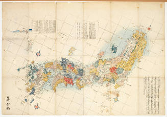
Map of the Japanese Archipelago
Honolulu Museum of Art
Honolulu Museum of Art Collection

Strategical Map of Part of Korea and Manchuria . . . 1906
Stanford University Libraries
Stanford Libraries SearchWorks
The northern part of Luzon Island, in the Philippines, where a large Japanese force is reported to be attemp...
National Library of New Zealand
DigitalNZ New Zealand API

Map of Japanese Homeland Island
Philadelphia Museum of Art
Philadelphia Museum of Art collection

Geologic map of the eastern part of Hakone Volcano
Stanford University Libraries
Stanford Libraries SearchWorks
[Japanese map of World War ll]
National Library of Australia
Trove: National Library of Australia

Chart of the coast of China and of the Japan islands including the Marianes and part of the Philippines
Boston Public Library
DPLA API

Strategical map of part of Korea and Manchuria / prepared by the Second Division, General Staff (Military In...
Yale University Library
Yale University Library Digital Collections

Map of the Japanese telegraph system
Boston Public Library
DPLA API
![[Taisho Japanese map of the world. Taisho Japanese map of Japan and Korea]. [9 insets].](https://stacks.stanford.edu/image/iiif/yj892bp5625%2F11670000/full/!200,200/0/default.jpg)
[Taisho Japanese map of the world. Taisho Japanese map of Japan and Korea]. [9 insets].
Stanford University Libraries
Stanford Libraries SearchWorks

(Eastern Part of Asia, including China, Korea, Japan, Philippines : Untitled Globe Gores)
Stanford University Libraries
Stanford Libraries SearchWorks
[Japanese map of World War II]
National Library of Australia
Trove: National Library of Australia

Dai Nihon zenzu (The picture of the Great Whole Map of Japan; Provinces in the Japanese Empire, in...
Stanford University Libraries
Stanford Libraries SearchWorks

Map of Hiroshima (Object)
British Museum
British Museum Collection

CAPITAL OF THE PHILIPPINES RUTHLESSLY BOMBED BY JAPANESE
Auckland Libraries
DigitalNZ New Zealand API

General map of the Government Railways in Japan
General Research Division. The New York Public Library
DPLA API

Map of the Empire of Japan in 1914
New Zealand Ministry for Culture and Heritage
DigitalNZ New Zealand API

A Map of Marco Polo's Voyages & Travels in the 13th Century trhough a great Part of Asia, all Tart...
Stanford University Libraries
Stanford Libraries SearchWorks

IN FORMER JAPANESE-OCCUPIED TERRITORY: PART OF A ROYAL NEW ZEALAND AIR FORCE CAMP ON GUADALCANAR ISLAND IN T...
Auckland Libraries
DigitalNZ New Zealand API

Map of Northern Japan. Map of Southern Japan
Bibliothèque nationale de France
Europeana API

Russo-Japanese war map
Bibliothèque nationale de France
Europeana API

「祇園会十四日浮橋館幸之図」
C. V. Starr East Asian Library, University of California, Berkeley
ARC Ukiyo-e Portal Database

Gomanbunnoichi chikeizu Takuroban kinbō
Stanford University Libraries
Stanford Libraries SearchWorks
Woodblock
Metropolitan Museum of Art
The Metropolitan Museum of Art Open Access CSV

Map of Chosen (Korea)
Yale University Library
Yale University Library Digital Collections

「洛西御室仁和寺御境内風景并御山八十八ヶ所」
C. V. Starr East Asian Library, University of California, Berkeley
ARC Ukiyo-e Portal Database
Yohwa noin hoegŭnch'ŏp, 1908
Yale University Library
Yale University Library Digital Collections

(Composite Map of) Map of the Island of Japan, Kurile &c. with the Adjacent Coasts of the Chinese ...
Stanford University Libraries
Stanford Libraries SearchWorks

Laurie and Whittle's New Chart of the Indian and Pacific Oceans Between the Cape of Good Hope, New...
Stanford University Libraries
Stanford Libraries SearchWorks
![[Map of China]](https://collections.library.yale.edu/iiif/2/16189150/full/!200,200/0/default.jpg)
[Map of China]
Yale University Library
Yale University Library Digital Collections

An Accurate Chart of the World, with the New Discoveries; Also a View of the General & Coasting Tr...
Stanford University Libraries
Stanford Libraries SearchWorks
布袋図
Tokyo National Museum
ARC Ukiyo-e Portal Database
Japanse schildering van landschap met rivier
Royal Library of the Netherlands
Europeana API

「四条川原新大涼風景」
C. V. Starr East Asian Library, University of California, Berkeley
ARC Ukiyo-e Portal Database

「鎌倉一覧之図」
Tokyo Metropolitan Central Library
ARC Ukiyo-e Portal Database
Eis van de opperburgermeester
Royal Library of the Netherlands
Europeana API
Pacific Ocean [by Sidney E. Morse]
National Library of Australia
Trove: National Library of Australia
Asia and its several islands and regions : according to their most approved divisions with Captain Cooks new discoveries / by Thomas Kitchin, Hydrographer to His Majesty
National Library of Australia
Trove: National Library of Australia

「増補 江戸名所古跡神社仏閣独案内記」
Tokyo Metropolitan Central Library
ARC Ukiyo-e Portal Database

Carte Physique & Politique. : No. 16 : l'Asie
Yoshida-South Library, Kyoto University
IIIF Discovery in Japan
Twee bruggen over een rivier
Royal Library of the Netherlands
Europeana API
Australien / wolfenbuttel bei C. H. Hartmann
National Library of Australia
Trove: National Library of Australia
Stencil
Metropolitan Museum of Art
The Metropolitan Museum of Art Open Access CSV

Asia According to the best Authorities
Stanford University Libraries
Stanford Libraries SearchWorks

Jūmanbun no ichizu Saharinwan
Stanford University Libraries
Stanford Libraries SearchWorks
Last Updated: 2021-01-30
Uploaded: 2021-07-29