Japan the country / Sydney Morning Herald ; designed by the Art Dept. of John Fairfax and Sons Limited
- People
- Time
- Owner Organization
Japan : the country / Sydney Morning Herald ; designed by the Art Dept. of John Fairfax and Sons Limited

A pictorial map : Victory in the Pacific Designed and published by Ernest Dudley Chase of Winchest...
A chart of the South Sea / by John Seller, Hydrographer to the Kings most Excellent Majestie ; Dundee, sculp

Stainless steel table fork, part of a stainless steel and gilt brass cutlery set, designed by Gunn...
The Coffin Islands / surveyed by order of Commodore M.C. Perry U.S.N. by Lieuts. G.B. Balch, G.H. Cooper & L.A. Beardslee Mid. of the U.S. Ship Plymouth Commander John Kelly U.S.N. ; engraved by S. Siebert, lettering by C.A. Knight
Aerial view of the country looking towards Castelfrentano, Italy, World War II - Photograph taken by George ...

A Country Bridge, The Construction of This Bridge Seems Very Wonderful to Travellers. It is Formed by Two Vi...
Pacific war map / Dept. of Home Security ; issued by authority of the Minister for Home Security with the permission of Associated Newspapers Ltd
Wreckage of a harbour vessel sunk at her moorings in Sydney Harbour by the blast of a Japanese torpedo when ...
Navigantium atque itinerantium bibliotheca ; Or, A complete collection of voyages and travels : Consisting of above six hundred of the most authentic writers ... Containing whatever has been observed worthy of notice in Europe, Asia, Africa, and America ... the climate, soil and produce ... of each country: likewise the religion, manners, and customs ... To which is prefixed a copious introduction, comprehending the rise and progress of the art of navigation ... together with the invention and use of the loadstone ... / by John Harris ... .
The Oriental navigator, or, Directions for sailing to, from, and upon the coasts of, the East-Indies, China, Australia...To the work are prefixed a series of ... tables of the determined positions of all the principle points and places from the British seas to Cape Horn, the Cape of Good Hope, and thence to the islands of Japan, by John Purdy. (Plan of Chatham Island, &c. Whittle & Laurie, London, 1815.)
The country trade East-India pilot, for the navigation of the East-Indies and oriental seas, within the limits of the East-India Company, extending from the Cape of Good Hope to China, New Holland and New Zeeland, with the Red Sea, Gulf of Persia, Bay of Bengal, and China Seas / chiefly composed from actual surveys and draughts communicated by experienced officers of the East-India Company, and from the Neptune oriental by M. d'Apres de Mannevillette
Caroline Islands 1:25,000 : Yap / prepared under the direction of Engineer, Hq AFFE/BA, by the Military Geology Branch, Intelligence Division ; map compiled by C. G. Johnson, geologist, Military Geology Branch, U.S. Geological Survey, for the Intelligence Division, Office of the Engineer, Hq. U.S. Army Japan

名古屋城御普請図 : 名古屋城御普請図
名古屋東別院図 : 名古屋東別院図
大沢龍蔵寺絵図 : 大沢龍蔵寺絵図
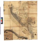
熱田より桑名迄海上絵図 : 熱田より桑名に至る海上図

「三十六歌仙 童女教訓鏡」 「藤原高光」
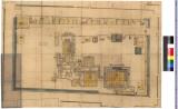
西尾城内本丸間取図 : 西尾城内本丸間取図

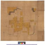
古渡村絵図 : 古渡村絵図

「西行もまた見ぬはなの廓かな」 「〔西行もまた見ぬ花の廓かな〕(短冊)」

根津権現社
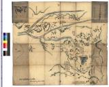
長久手古戦場之図 : 長久手古戦場図
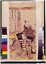
「中村仲蔵」

郡山附近地形図

〈樺太〉豊原全図 : 樺太豊原全図

Komusō

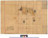
金沢藩御殿図 : 金沢城及営中図

巣鴨 庚申塚
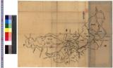
山城国図 : 山城国図

Kabuki jūhachiban
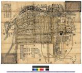
〈改正〉大坂大絵図 : 大阪図

「順路記(江戸城内一部)」

「出羽酒田」「松林銘(畳物)」
![[Jūichidanme - act eleven of the Chūshingura - discover Kira's hiding place]](https://tile.loc.gov/storage-services/service/pnp/jpd/00200/00299_150px.jpg)
[Jūichidanme - act eleven of the Chūshingura - discover Kira's hiding place]

hashira-e

蝦夷人地曳網漁之図
Last Updated: 2020-06-05
Uploaded: 2021-07-22