The Oriental navigator, or, Directions for sailing to, from, and upon the coasts of, the East-Indies, China, Australia...To the work are prefixed a series of ... tables of the determined positions of all the principle points and places from the British seas to Cape Horn, the Cape of Good Hope, and thence to the islands of Japan, by John Purdy. (Plan of Chatham Island, &c. Whittle & Laurie, London, 1815.)
- People
- Time
- Owner Organization

Laurie and Whittle's New Chart of the Indian and Pacific Oceans Between the Cape of Good Hope, New...

Laurie and Whittle's New Chart of the Indian and Pacific Oceans Between the Cape of Good Hope, New...
Laurie and Whittle's new chart of the Indian and Pacific Oceans between the Cape of Good Hope, New Holland, and Japan, comprehending New Zealand, New Caledonia, New Britain, New Ireland, New Guinea,&c., Louisiade and New Georgia; also the Pelew, New Caroline, Ladrone, and Philippine Islands; &c. with the most remarkable tracks of the English, Spanish, French and Dutch navigators: and chiefly the track of the Walpole, Eastindiaman, Captn. Thos. Butler, 1794 from the Cape of Good Hope to Van Diemen's Land and, from thence to China, and the track of the Royal Admiral Captn. Henr. Bond in 1792 and 93, from the Cape to Port Jackson and China
Laurie and Whittle's new chart of the Indian and Pacific Oceans between the Cape of Good Hope, New Holland and Japan : comprehending New Zealand, New Caledonia, New Britain, New Ireland, New Guinea &c., Louisiade and New Georgia; also The Pelew, New Caroline, Ladrone and Philippine Islands &c. with the most remarkable tracks of the English, Spanish, French and Dutch navigators and chiefly the track of the Walpole, EastIndiaman, Captn. Thos. Butler, 1794 from the Cape of Good Hope to Van Diemen's Land and from thence to China, and the track of the Royal Admiral Captn. Henr. Bond in 1792 and 93 from the Cape to Port Jackson and China
![A particular map of the voyage from Kokura to Simonoseki [Shimonoseki-shi], and thence to Osacca [Osaca]](https://dp.la/thumb/253a40138432c08b8025bf838a11d00b)
A particular map of the voyage from Kokura to Simonoseki [Shimonoseki-shi], and thence to Osacca [Osaca]

A Chart of the Eastermost part of the East Indies and China from Cape Comarin to Japan with the Ad...

A Chart of the Eastermost part of the East Indies and China from Cape Comarin to Japan with the Ad...
![A particular map of the road from Osacca [Osaca] to Miaco [Miyako-shi], and from thence to Fammamatz [Hamama...](https://dp.la/thumb/f741e82fc81a962d8a2a6c5659d34013)
A particular map of the road from Osacca [Osaca] to Miaco [Miyako-shi], and from thence to Fammamatz [Hamama...

(Lower Sheet to) Map of the Island of Japan, Kurile &c. with the Adjacent Coasts of the Chinese Do...

(Upper Sheet to) Map of the Island of Japan, Kurile &c. with the Adjacent Coasts of the Chinese Do...
Map of the Island of Japan, Kurile &c. with the Adjacent Coasts of the Chinese Dominions and a Ske...

Map of the Island of Japan, Kurile &c. with the Adjacent Coasts of the Chinese Dominions and a Ske...
Japan Islands and eastern coasts of Korea and Siberia from Tsu Sima to Gulf of Tartary : index to Admiralty published charts / Hydrographic Office

A New Chart of The Pacific Ocean, Exhibiting The Western Coast of America, From Cape Horn To Beeri...

A New Chart of The Pacific Ocean, Exhibiting The Western Coast of America, From Cape Horn To Beeri...
A New Chart of The Pacific Ocean, Exhibiting The Western Coast of America, From Cape Horn To Beeri...
A chart of the eastermost part of the East Indies with all the adjacent islands from Cape Comorin to Iapan / by Iohn Seller, Hydrographer to the King

A chart of the easternmost part of the East Indies with all the adjacent islands from Cape Comorin...

A new chart of the Pacific Ocean : exhibiting the western coast of America, from Cape Horn to Beerings Strait, the eastern shores of Asia including Japan, China and Australia and all the numerous islands and known dangers situated in Polynesia and Australasia / correctly drawn and regulated according to the most approved and modern surveys and astronomical observations by J.W. Norie
A chart of the eastermost part of the East Indies with all the adjacent islands from Cape Comorin to Iapan / by Iohn Seller, Hydrographer to the King ; F. Lamb Sculp
The country trade East-India pilot, for the navigation of the East-Indies and oriental seas, within the limits of the East-India Company, extending from the Cape of Good Hope to China, New Holland and New Zeeland, with the Red Sea, Gulf of Persia, Bay of Bengal, and China Seas / chiefly composed from actual surveys and draughts communicated by experienced officers of the East-India Company, and from the Neptune oriental by M. d'Apres de Mannevillette
A New Chart of the Indian and Pacific Oceans Between the Cape of Good Hope, New Holland, and Japan...

Japan from "Notes and Sketches from the wild coasts of Nipon, with chapters of cruising after pira...

A New Chart of The Pacific Ocean, Exhibiting The Western Coast of America from Cape Horn to Beerin...
![[Taiwan and the Coast of Fujian and Guandong, China] Kaart van de Chineesche Kust en van Formosa v...](https://stacks.stanford.edu/image/iiif/zy510ks0323%2F34567/full/!200,200/0/default.jpg)
[Taiwan and the Coast of Fujian and Guandong, China] Kaart van de Chineesche Kust en van Formosa v...
Arai, 32nd of 53 Stations of the Tōkaidō (Tōkaidō gojūsan-tsugi no uchi: Arai)
![[Carte abrégée de la ville d'Osaka, divisée en quartiers.]](https://api.europeana.eu/api/v2/thumbnail-by-url.json?uri=http%3A%2F%2Fgallica.bnf.fr%2Fark%3A%2F12148%2Fbtv1b530667803.thumbnail.jpg&type=IMAGE)
[Carte abrégée de la ville d'Osaka, divisée en quartiers.]
![[Palembang and Bangka Island, Indonesia] Het Eiland Banka. 1819 [and] De Rivier van Palembang. 1821](https://stacks.stanford.edu/image/iiif/vz793zp5933%2F36200/full/!200,200/0/default.jpg)
[Palembang and Bangka Island, Indonesia] Het Eiland Banka. 1819 [and] De Rivier van Palembang. 1821

A New & Accurate Chart of the Discoveries made by the late Capt. Js. Cook, and other distinguished...

「従三条大橋諸方位里程」
The island of Formosa

Skizze des weges von Tokio nach Yumotto (Nikko Berge) nach eigenen Aufzeichnungen / von E. Knippin...

Carte réduite de l'océan septentrional compris entre l'Asie et l'Amérique ... Par le Sr. Bellin ..

Japon. Carte / dressée pour les missions catholiques par M. R. Hausermann ; avec le concours de M....
![[Carte de Lieou Kieou] / [par Shihei Hayashi]](https://api.europeana.eu/api/v2/thumbnail-by-url.json?uri=http%3A%2F%2Fgallica.bnf.fr%2Fark%3A%2F12148%2Fbtv1b55000388q.thumbnail.jpg&type=IMAGE)
[Carte de Lieou Kieou] / [par Shihei Hayashi]
![[Japan] (Published in Manila!)](https://stacks.stanford.edu/image/iiif/gv355sq3352%2F37869hs/full/!200,200/0/default.jpg)
[Japan] (Published in Manila!)
![[歴民カード_考古] 斧形鋳鉄(1)](https://khirin-i.rekihaku.ac.jp/iiif/nmjh_rekimin_a/23347001_02.tif/full/200,/0/default.jpg)
[歴民カード_考古] 斧形鋳鉄(1)

Mare Del Sud Detto Altrimente Mare Pacifico
Eis van de gouverneur van Nangasakij

Partie Septentrionale De L'Ocean Pacifique ou L'on Marque Les Decouvertes Et Les Routes De Mrs. De...
Nitshikan kōro ryakuzu
Eis van de tweede raadsheer

Plan of Hong Kong City of Victoria . . .
Eis van de gouverneur van Nangasakij

Geological map of Hokkaido = 北海道地質圖
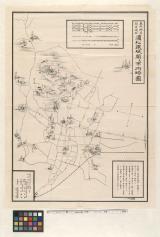
東照神君開運城跡浜松鉄城閣及市街略図
瀬貞蔵本
![[歴民カード_考古] 高蔵寺第20号窯](http://khirin-i.rekihaku.ac.jp/iiif/nmjh_rekimin_a/22747084_02.tif/full/200,/0/default.jpg)
[歴民カード_考古] 高蔵寺第20号窯
Last Updated: 2020-06-05
Uploaded: 2021-07-22