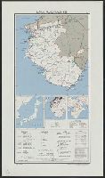
Japan--USSR : northern territories / Central Intelligence Agency
- Time
- Owner Organization

Central Japan (central and northern Honshū) water supply

Central Japan (central and northern Honshū) distribution of population
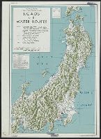
Central Japan :

Northern territories and Japan-Russia Relations: Will the Knot ever Untie

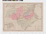
Central Japan (Central and Northern Honshū). Administrative divisions. No. 5282
Northern territories and Japan-Russia relations: Latest developments under prime minister Taro Aso
Japan’s National Identity, Territorial Disputes and Sub-state Actors: Northern Territories/South K...

Ireland. Japan. Central Africa. India

Country intelligence reports on Japan
Joint Army-Navy Intelligence Study of Central Japan, Central and Northern Honshu, Regional Summary, JANIS 85, February 1945, Chapter 1-2

Map of Northern Japan. Map of Southern Japan
Joint Army-Navy Intelligence Study of Central Japan, Central and Northern Honshu, Regional Summary, JANIS 85-2, February 1945, Figures S-19 to S-41
Joint Army-Navy Intelligence Study of Central Japan, Central and Northern Honshu, Regional Summary, JANIS 85-2, February 1945, Figures S-1 to S-18

The Ainusa tribe from Northern Japan

A handbook for travellers in central & northern Japan : being a guide to Tōkiō, Kiōto, Ozaka, Hako...
Joint Army-Navy Intelligence Study of Central Japan, Central and Northern Honshu, Regional Summary, JANIS 85, February 1945, Chapter 3-15 and Plans (Maps) A to 41(b)

Tokyo central, Japan. (to accompany) Shomitsu Nippon chizu. (Atlas of Japan). Nippon Shoin. (Tokyo...
Central Africa, Japan and Fiji, a story of missionary enterprise

The war against Japan (Map USSR, China & Australia)
The Central Keep of the Citadel of the Castle of Nagoya, Japan

Osaka (Northern suburbs), Japan. (to accompany) Shomitsu Nippon chizu. (Atlas of Japan). Nippon Sh...

Series (Standard map series designation system) ; 5205
Snow and Daily Life in Northern Japan (Hokuetsu seppu) in 7 Volumes
China’s energy strategy in central Asia: interactions with Russia, India and Japan
Okinawa, Japan, administrative divisions
Northeast Asia

City plan of Kōbe.

Izu, Bonin and Volcano Islands : Strategic location
Japan, Okinawa

Southwest Japan (Kyūshū, Shikoku, and southwest Honshū), telecommunications

10年のあゆみ The Past 10 Years' Progress

Japan, Miyazaki-ken.
Japan, Wakayama-ken
![豊橋市街図 [昭和13年] 複製](https://adeac.jp/items/toyohashi-city/catalog/mp000160-200030/t.jpg)
豊橋市街図 [昭和13年] 複製

Southwest Japan (Kyūshū, Shikoku, and southwest Honshū), railroads and railroad facilities [cartog...
山口史蹟図

Japan, Oita-ken

Japan, Mie-ken.

Chiba
最新調査四国全図
![Japan, Wakayama-ken [cartographic material]](https://stacks.stanford.edu/image/iiif/fk546zc0893%2Ffk546zc0893_00_0001/full/!200,200/0/default.jpg)
Japan, Wakayama-ken [cartographic material]

Southwest Japan (Kyūshū, Shikoku, and southwest Honshū), lumber and allied industries [cartographi...
![Japan [cartographic material] : ports of greatest shipping activity](https://stacks.stanford.edu/image/iiif/yg817zs3009%2Fyg817zs3009_00_0001/full/!200,200/0/default.jpg)
Japan [cartographic material] : ports of greatest shipping activity
![Japan : Kyoto-Fu [cartographic material].](https://stacks.stanford.edu/image/iiif/sb905zv4061%2Fsb905zv4061_00_0001/full/!200,200/0/default.jpg)
Japan : Kyoto-Fu [cartographic material].

Cina, Mongolia. (insets) Pechino (Beijing), Tientsin, Shanghai, Yanking, Hankow and Canton
Map of Japan
Map of Japan. (sheet 3)
徳島県管内地図
Last Updated: 2020-06-05
Uploaded: 2021-07-22