
Military Map of South-Eastern Virginia
- People
- Time
- Owner Organization

Map of Eastern U.S.S.R. Missile Bases
![[Manchuria] (7 sheet US Military Information Division Map of Manchuria)](https://stacks.stanford.edu/image/iiif/yr430hp5690%2F41524/full/!200,200/0/default.jpg)
[Manchuria] (7 sheet US Military Information Division Map of Manchuria)

Geologic map of the eastern part of Hakone Volcano

Plans in south eastern part of New Guinea
A map of South China, scene of the latest military operations by the Japanese. , (Evening Post, 13 October 1...
Cook's map of the tourist districts of New South Wales

Plans in the south-eastern part of New Guinea

The New War Map of Maryland Part of Virginia & Pennsylvania. Published by B.B. Russell . .

Strategical map of part of Korea and Manchuria / prepared by the Second Division, General Staff (Military In...

Map of Northern Japan. Map of Southern Japan
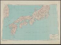
Japan (North) :
Map of Tokyo
Japan (South) special strategic map / compiled by the Army Map Service
![[Map of East Asia]](https://stacks.stanford.edu/image/iiif/kg150vx7689%2F41423/full/!200,200/0/default.jpg)
[Map of East Asia]

Map of Manchuria, Corea & Japan

Colton's Rail-road and Military Map of the United States, Mexico, the West Indies, &c…1861

The topographic map of Manchoukuo
Keifu Testudō senro ryakuzu = Map of the Seoul-Pusan Railway ; Fu Tōyō Tetsudō senro ryakuzu = Map of the Eastern Railways

Map of Tokio

Map of Japan
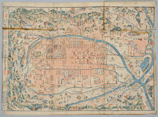
Map of Kyoto
[Map of Kyoto]
![[Map of Kyoto]](https://collections.library.yale.edu/iiif/2/15510884/full/!200,200/0/default.jpg)
[Map of Kyoto]

Map of Japan
![Kasei Kita Shina jūmanbun no ichi zu. Joshū (Xuzhou) [cartographic material]](https://stacks.stanford.edu/image/iiif/hr412vw3270%2Fhr412vw3270_00_0001/full/!200,200/0/default.jpg)
Kasei Kita Shina jūmanbun no ichi zu. Joshū (Xuzhou) [cartographic material]

Das Suedoestliche Asien oder China, Japan, und Hinter-Indien mit dem Indischen Archipelagus. (The ...

China and Japan

Central Tokyo : city map.
![Keijō Kinbō [cartographic material]](https://stacks.stanford.edu/image/iiif/jk515ck5320%2Fjk515ck5320_00_0001/full/!200,200/0/default.jpg)
Keijō Kinbō [cartographic material]

Map of the Empire of China and Japan. J.W. del. (engraved by) Stockley, Sc London, James Wyld, Cha...

China, Contains 15 Subject Provinces, including the 2 Islands of Hainan Formosa and the Tributary ...
![Nimangosenbun no ichi chikeizu Parao Rettō [cartographic material]](https://stacks.stanford.edu/image/iiif/dx617ts1787%2Fdx617ts1787_00_0001/full/!200,200/0/default.jpg)
Nimangosenbun no ichi chikeizu Parao Rettō [cartographic material]
Hakutakunozu

Nagasaki harbor

L'Empire de la Chine d'après l'Atlas Chinois avec les Isles du Japon . .

Mandchourie et Coree de Kharbine a Seoul de Port-Arthur a Vladivostok Traduction de la Carte d'Eta...

下志津原演習場

Asia According to the best Authorities

Manshū jūmanbun no ichizu Chūbu Daikōanrei
![Indo oyobi Seia [cartographic material] : Roppyakmanbun no ichi](https://stacks.stanford.edu/image/iiif/dx650yf2686%2Fdx650yf2686_00_0001/full/!200,200/0/default.jpg)
Indo oyobi Seia [cartographic material] : Roppyakmanbun no ichi
Strategical map of part of Korea and Manchuria / prepared by the Second Division, General Staff (Military In...
最新豊橋市街地図 番地入 縮尺:一万分の一 昭和14年

Tōkyō shigai zenzu
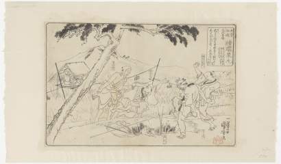
「木曽街道 膝栗毛」「大久手」

Nova Totius Regni Bohemiae Tabula Reverendissimis Celsissimis, Illustrissimis et Excellentissimis ...
習志野演習場

Russia in Asia, Chinese Empire, etc. No. 3. Letts's popular atlas. Letts Son & Co. Limited, London...

China divided into its Great Provinces, and The Isle of Japan . . . 1774
Last Updated: 2020-04-17
Uploaded: 2021-09-21