
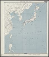
Approaches to Japan
![Approaches to Japan [cartographic material].](https://stacks.stanford.edu/image/iiif/zs924cb7981%2Fzs924cb7981_00_0001/full/!200,200/0/default.jpg)
Approaches to Japan [cartographic material].

New Guinea - South-East Coast. Approaches to Dedele
Outskirts of Makassar in Celebes

Pacific Ocean, Approaches to south east part of New Guinea
Output Inter-Sampling Approaches to System Identification
Self-consistent approaches to the localization transition
Penalized likelihood approaches to nonparametric regression problems

Wasplaats van het interneringskamp te Makassar

Asia : Coast of China : Ryōtō Kaiwan. Approaches to Ryō Ga Entrance
Novel approaches to NMR analysis of complicated organic molecules

Japan, Kyūshū--south coast : approaches to Osumi Kaikyo (Van Diemen Strait) (Eastern part)
![[Twerkgestelde Japanse krijgsgevangenen op de rede van Makassar.]](https://api.europeana.eu/api/v2/thumbnail-by-url.json?uri=http%3A%2F%2Fwww.beeldbankwo2.nl%2Fcgi-bin%2Ffrsiserver.dll%2Fthumbnail%2F51713-thumb.jpg%3Ffrskey%3D51713&type=IMAGE)
[Twerkgestelde Japanse krijgsgevangenen op de rede van Makassar.]

China - east coast : Hangchow Wan - southeast portion : including the approaches to the Yung Kiang

Meisje in Japans interneringskamp in Makassar na de bevrijding

West Coast of Korea. Approaches to Séoul : with Sir James Hall Group and Ta-Tong River

Four Approaches to Japan. From Alaska. From China-Burma. From Manchuria. From the S.W. Pacific. Ne...

Eastern Archipelago : Celebes - East Coast. Tg. Losoni to Northern Entrance to Buton Str.
Pendoedoek Indonesia disebelah timoer dari laoetan Makassar dan Lombok. (Aan de Indonesische bevol...
Japanese CP Approaches Western European Revisionists
One of the dumptors used in the construction of the approaches to the Bailey bridges across the Sangro River...
Studies on the synthetic approaches to regio- and stereoselectively deuterium-labelled compounds via reductive deuteration
Green function and density functional approaches to non born-oppenheimer and proton and electron cooperative systems
SCAPIN-1907/1: NORTHERN HONSHU AIR TO AIR RANGE 1948/09/01
Asia : Coast of China : Ryōtō Kaiwan. Approaches to Ryō Ga Entrance

Salayar Strait to Tana Keke I.

Yōzu (kūchū shashin sokuryō) Mōko jūmanbun no ichizu

Plans of Anchorages in Tomori Gulf and Adjacent Coast
![Sanjūmanbun no ichi Shina engan rikukai hengōzu [cartographic material]](https://stacks.stanford.edu/image/iiif/cn019rx5665%2Fcn019rx5665_00_0001/full/!200,200/0/default.jpg)
Sanjūmanbun no ichi Shina engan rikukai hengōzu [cartographic material]

Futsuryō Indoshina Gojūmanbunnoichi Zu = Carte de l'Indochine

Hermit Islands

Central Portion of Sumbawa with Pulo Tenga Islands

Shukusei Karafuto jūmanbun no ichi zu

Plans on the West Coast of Celebes
![Ichimanbun no ichi chikeizu Shinkyō kinbō [cartographic material]](https://stacks.stanford.edu/image/iiif/jc790cg6868%2Fjc790cg6868_00_0001/full/!200,200/0/default.jpg)
Ichimanbun no ichi chikeizu Shinkyō kinbō [cartographic material]

Niman-gosenbun no ichi chikeizu : Karafuto hokubu
![Nimanbun no ichi Honkon Kinbō [cartographic material]](https://stacks.stanford.edu/image/iiif/nv455pd8800%2Fnv455pd8800_00_0001/full/!200,200/0/default.jpg)
Nimanbun no ichi Honkon Kinbō [cartographic material]

Mōko Nijūmanbunnoichi Utoku chihō

North Part of Kokai : Takushan Road and Approaches

Carta General Para Las Navegaciones a la India Oriental Por El Mar Del Sur Y el grande Oceano que ...

Impero del Giappone. Questa Carta e stata eseguita su quella pubblicata in Londra nel 1835, dalla ...

Junka = Zunhua

Ryōtō Kaiwan : Daitzu Shan to Fuchou Chao

Hyakumanbunnoichi Kōkūzu

Taitōei
日本国図

An Accurate Chart of the World, with the New Discoveries; Also a View of the General & Coasting Tr...

太湖 特第3号
Last Updated: 2020-04-17
Uploaded: 2021-09-21