
Eastern Archipelago : Celebes - East Coast. Tg. Losoni to Northern Entrance to Buton Str.
- Time
- Owner Organization

Eastern Archipelago : Eastern Part of Celebes
Stanford University Libraries
Stanford Libraries SearchWorks

merikartta; East India Archipelago. Eastern passages to China and Japan
Finnish Heritage Agency
Europeana API

Celebes - West Coast : Cape William to Tandyung Karang
Stanford University Libraries
Stanford Libraries SearchWorks

Eastern Archipelago, Arafura Sea. Tanimbar Islands
Stanford University Libraries
Stanford Libraries SearchWorks

Plans on the West Coast of Celebes
Stanford University Libraries
Stanford Libraries SearchWorks
![East India Archipelago [Eastern Passages to China and Japan] [Chart No. 2] . . . 1868 (North Austr...](https://stacks.stanford.edu/image/iiif/hf333br4460%2F34582/full/!200,200/0/default.jpg)
East India Archipelago [Eastern Passages to China and Japan] [Chart No. 2] . . . 1868 (North Austr...
Stanford University Libraries
Stanford Libraries SearchWorks

Eastern Archipelago. Flores and Timor Seas
Stanford University Libraries
Stanford Libraries SearchWorks

Eastern Archipelago. Plans in Sermata Islands
Stanford University Libraries
Stanford Libraries SearchWorks
![East India Archipelago [Eastern Passages to China and Japan] [Chart No. 4] . . . 1868 (Mindanao, B...](https://stacks.stanford.edu/image/iiif/qk341np8650%2F34532/full/!200,200/0/default.jpg)
East India Archipelago [Eastern Passages to China and Japan] [Chart No. 4] . . . 1868 (Mindanao, B...
Stanford University Libraries
Stanford Libraries SearchWorks
East India Archipelago (Eastern passages to China and Japan) / compiled by James F. Imray, F.R.G.S
National Library of Australia
Trove: National Library of Australia
![East India Archipelago [Eastern Passages to China and Japan] [Chart No. 7] . . . 1868 (Taiwan, Nor...](https://stacks.stanford.edu/image/iiif/xy078vp9272%2F34545/full/!200,200/0/default.jpg)
East India Archipelago [Eastern Passages to China and Japan] [Chart No. 7] . . . 1868 (Taiwan, Nor...
Stanford University Libraries
Stanford Libraries SearchWorks
![East India Archipelago [Eastern Passages to China and Japan] [Chart No. 1] . . . 1866 (Java, Borne...](https://stacks.stanford.edu/image/iiif/ww842xr3210%2F34640/full/!200,200/0/default.jpg)
East India Archipelago [Eastern Passages to China and Japan] [Chart No. 1] . . . 1866 (Java, Borne...
Stanford University Libraries
Stanford Libraries SearchWorks

Asia : Coast of China : Ryōtō Kaiwan. Approaches to Ryō Ga Entrance
Stanford University Libraries
Stanford Libraries SearchWorks

New Guinea - South-East Coast. Approaches to Dedele
Stanford University Libraries
Stanford Libraries SearchWorks

Eastern Archipelago : Flores Sea. Tana Jampea and Adjacent Islands
Stanford University Libraries
Stanford Libraries SearchWorks

Entrance to the city
National Gallery of Australia
Trove: National Library of Australia
E4 Entrance to Gongen
Harvard Art Museums
Harvard Art Museums API

Entrance to Cracroft caverns
http://ketechristchurch.peoplesnetworknz.info/
DigitalNZ New Zealand API

Entrance to Nagasaki harbor
Rijksmuseum
Europeana API

Plans on the north-eastern coast of New Guinea
Stanford University Libraries
Stanford Libraries SearchWorks

Entrance To Golden Temple, Amritsar
Freer and Sackler
DPLA API

Entrance to Albert Park tunnels
New Zealand Ministry for Culture and Heritage
DigitalNZ New Zealand API

Entrance to Fukiage Gardens, Tokio
The Miriam and Ira D. Wallach Division of Art, Prints and Photographs. The New York Public Library
DPLA API
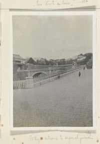
Tokyo entrance to imperial palace
Rijksmuseum
Rikijmuseum API
Celebes - West Coast : Cape William to Tandyung Karang
Stanford University Libraries
Stanford Libraries SearchWorks

Jūmanbunnoichi Guamutō fukin
Stanford University Libraries
Stanford Libraries SearchWorks
Eastern Archipelago : Flores Sea. Tana Jampea and Adjacent Islands
Stanford University Libraries
Stanford Libraries SearchWorks
Eastern Archipelago. Flores and Timor Seas
Stanford University Libraries
Stanford Libraries SearchWorks
Eastern Archipelago : Eastern Part of Celebes
Stanford University Libraries
Stanford Libraries SearchWorks

Imperii Sinarum nova descriptio
Stanford University Libraries
Stanford Libraries SearchWorks

Carte De L'Oceanie Contenant L'Australe, La Polynesie et Les Iles Asiatique [Australia called Nota...
Stanford University Libraries
Stanford Libraries SearchWorks

Japan and South Manchuria : Railway and steamer connections
Stanford University Libraries
Stanford Libraries SearchWorks
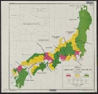
Japan : industrial concentration by prefectures
Yale University Library
Yale University Library Digital Collections

Recentissima NOVI ORBIS, Sive AMERICÆ SEPTENTRIONALIS et MERIDIONALIS TABULA
Stanford University Libraries
Stanford Libraries SearchWorks

Japan and it's relation to the territory bordering on the Pacific ocean
Yale University Library
Yale University Library Digital Collections
![Suirobu Hi [Kaizu]](https://stacks.stanford.edu/image/iiif/nm634np1065%2Fnm634np1065_0001/full/!200,200/0/default.jpg)
Suirobu Hi [Kaizu]
Stanford University Libraries
Stanford Libraries SearchWorks

Imperio Del Giappone
Stanford University Libraries
Stanford Libraries SearchWorks

Descripcion De Las Indias Del Poniente
Stanford University Libraries
Stanford Libraries SearchWorks
Nemuro
Yale University Library
Yale University Library Digital Collections

Atlantis Insula
Stanford University Libraries
Stanford Libraries SearchWorks

Empire of Japan ... Published under the Supervision of the Society for the Diffusion of Useful Kno...
Stanford University Libraries
Stanford Libraries SearchWorks

Hiratsuka
Stanford University Libraries
Stanford Libraries SearchWorks

Guide to Tokyo City
Yale University Library
Yale University Library Digital Collections

Rand, McNally & Company's indexed atlas of the world map of Japan Copyright 1892, by Rand, McNally...
Stanford University Libraries
Stanford Libraries SearchWorks

Nemuro
Yale University Library
Yale University Library Digital Collections
![Nijumanbunnoichi zu pantaruto [cartographic material] : Daitoshu timorushu oyobi zokuchi](https://stacks.stanford.edu/image/iiif/vs896bc0895%2Fvs896bc0895_00_0001/full/!200,200/0/default.jpg)
Nijumanbunnoichi zu pantaruto [cartographic material] : Daitoshu timorushu oyobi zokuchi
Stanford University Libraries
Stanford Libraries SearchWorks

Japan: Topography and industrial areas
Stanford University Libraries
Stanford Libraries SearchWorks

North Pacific Ocean : Eastern Part of Hawaiin Islands
Stanford University Libraries
Stanford Libraries SearchWorks
Last Updated: 2020-04-17
Uploaded: 2021-09-21