East India Archipelago (Eastern passages to China and Japan) / compiled by James F. Imray, F.R.G.S
- Time
- Owner Organization

merikartta; East India Archipelago. Eastern passages to China and Japan
![East India Archipelago [Eastern Passages to China and Japan] [Chart No. 4] . . . 1868 (Mindanao, B...](https://stacks.stanford.edu/image/iiif/qk341np8650%2F34532/full/!200,200/0/default.jpg)
East India Archipelago [Eastern Passages to China and Japan] [Chart No. 4] . . . 1868 (Mindanao, B...
![East India Archipelago [Eastern Passages to China and Japan] [Chart No. 2] . . . 1868 (North Austr...](https://stacks.stanford.edu/image/iiif/hf333br4460%2F34582/full/!200,200/0/default.jpg)
East India Archipelago [Eastern Passages to China and Japan] [Chart No. 2] . . . 1868 (North Austr...
![East India Archipelago [Eastern Passages to China and Japan] [Chart No. 7] . . . 1868 (Taiwan, Nor...](https://stacks.stanford.edu/image/iiif/xy078vp9272%2F34545/full/!200,200/0/default.jpg)
East India Archipelago [Eastern Passages to China and Japan] [Chart No. 7] . . . 1868 (Taiwan, Nor...
Western Pacific / Compiled by James F. Imray F.R.G.S
![East India Archipelago [Eastern Passages to China and Japan] [Chart No. 1] . . . 1866 (Java, Borne...](https://stacks.stanford.edu/image/iiif/ww842xr3210%2F34640/full/!200,200/0/default.jpg)
East India Archipelago [Eastern Passages to China and Japan] [Chart No. 1] . . . 1866 (Java, Borne...

Eastern Archipelago : Celebes - East Coast. Tg. Losoni to Northern Entrance to Buton Str.
Wanderings east of Suez in Ceylon, India, China and Japan
China and Japan with adjoining countries / compiled and published by H.E.C.Robinson Pty. Ltd
The country trade East-India pilot, for the navigation of the East-Indies and oriental seas, within the limits of the East-India Company, extending from the Cape of Good Hope to China, New Holland and New Zeeland, with the Red Sea, Gulf of Persia, Bay of Bengal, and China Seas / chiefly composed from actual surveys and draughts communicated by experienced officers of the East-India Company, and from the Neptune oriental by M. d'Apres de Mannevillette

Sharpe's Corresponding Maps. South Eastern Asia. Birmah - China - Japan London - Published by Chap...
A chart of the northern part of the China Sea shewing the passage from Formosa to Japan with the eastern coast of China and the Lekeyo islands / by Van Kuelen ; improved from the maps drawn in China by Father Gaubil in 1752
The Eastern and Australian Steamship Company's illustrated handbook to the East : Australia, Manila, China and Japan : including trips to America and Europe / edited by W. Lorck
A chart of the northern part of the China Sea shewing the passage from Formosa to Japan : with the eastern coast of China and the Lekeyo Islands

A Chart of the Eastermost part of the East Indies and China from Cape Comarin to Japan with the Ad...

A Chart of the Eastermost part of the East Indies and China from Cape Comarin to Japan with the Ad...
Sketch of a voyage to the India and China seas, including Japan and the Pacific islands, for the p...
Map of the Japan Islands : copied from von Siebold's with slight additions & corrections, by the U.S. Japan Expedition and other authorities / Compiled by order of Commodore M.C. Perry, U.S.N. by Lieuts. W.L. Maury and Silas Bent ; James Ackerman, lith. 379 Broady NY
Nippon (Japan) 1876 : compiled from native maps and the notes of recent travellers / by R. Henry Brunton
A chart of ye eastermost part of the East Indies / by Iohn Seller

JAPAN MOVES SOUTHWARD IN THE FAR EAST: FRENCH TERRITORY OF INDO-CHINA OCCUPIED BY LAND AND AIR FORCES
Chart of the coast of China and of the Japan Islands including the Marianes and a part of the Philippines / compiled by order of Commodore M.C. Perry U.S.N. from the latest authorities with additions and corrections by the U.S. Japan Expedition by Lieuts. W.L. Maury and S. Bent U.S.N. ; drawn by Edw. Sels ; engr. by S. Siebert
Asia, c.1500 -- Asia, Ottoman Empire, Safavid Empire, India, Tibet, China, Mongolia, Laos, Siam, Burma, Sumatra, Malaya, Borneo, Java, Celebes, Philippines, Korea, Japan, Russia, Middle East Map / Maps.com(CR)
A chart of the eastermost part of the East Indies with all the adjacent islands from Cape Comorin to Iapan / by Iohn Seller, Hydrographer to the King ; F. Lamb Sculp
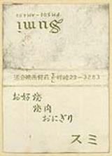
お好焼 焼肉 おにぎり スミ
「華頂山大谷寺知恩教院全図」
Eis van de keizerlijke majesteit
Kikujunokusazuri

「唐﨑一松景」「堅田落雁」「矢橋帰帆」 「KARASAKI OMI ST」「KATATA OMI」「YABASHI OMI」

「上毛四万温泉之図」

(宇治之景)

「三河国八橋山無量寺紫燕山在原寺八景之図」

Kūchū shashin yōzu Sanman Gosen bun no ichi Bisumaruku Guntō Tsurubu - Busshingu Misaki kan
Eis van de gouverneur van Nangasakij; werkkopie
Eis van de opperburgermeester
Ikiji、shinkiitten
Japan, the islands of Loochoo & Formosa, and the maritime provinces of China with the tract of the Morrison's voyage in 1837 / J. Arrowsmith, Lith

「鎌倉一覧之図」
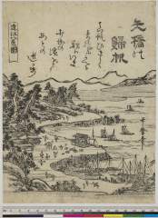
Oumihakkeinozuyabasenokihan
長島町五丁目大野屋惣八
Ugonotsuki
Eis van de keizerlijke majesteit

Ost-Indien
Eis van het college

Aru Shotō

「日本三景其一 奥州松島風景」
Kannoniwa

「守殿十景図」
Last Updated: 2020-06-05
Uploaded: 2021-07-22