
Eastern Archipelago. Sumba or Sandelhout
- Time
- Owner Organization

Eastern Archipelago : Eastern Part of Celebes

Eastern Archipelago, Arafura Sea. Tanimbar Islands

Eastern Archipelago. Plans in Sermata Islands

Eastern Archipelago. Flores and Timor Seas

Eastern Archipelago : Flores Sea. Tana Jampea and Adjacent Islands

merikartta; East India Archipelago. Eastern passages to China and Japan

Eastern Archipelago : Celebes - East Coast. Tg. Losoni to Northern Entrance to Buton Str.
![East India Archipelago [Eastern Passages to China and Japan] [Chart No. 4] . . . 1868 (Mindanao, B...](https://stacks.stanford.edu/image/iiif/qk341np8650%2F34532/full/!200,200/0/default.jpg)
East India Archipelago [Eastern Passages to China and Japan] [Chart No. 4] . . . 1868 (Mindanao, B...
.jpg)
SOUTH-EAST ASIA AND EAST INDIES ARCHIPELAGO
![East India Archipelago [Eastern Passages to China and Japan] [Chart No. 2] . . . 1868 (North Austr...](https://stacks.stanford.edu/image/iiif/hf333br4460%2F34582/full/!200,200/0/default.jpg)
East India Archipelago [Eastern Passages to China and Japan] [Chart No. 2] . . . 1868 (North Austr...
East India Archipelago (Eastern passages to China and Japan) / compiled by James F. Imray, F.R.G.S
![East India Archipelago [Eastern Passages to China and Japan] [Chart No. 7] . . . 1868 (Taiwan, Nor...](https://stacks.stanford.edu/image/iiif/xy078vp9272%2F34545/full/!200,200/0/default.jpg)
East India Archipelago [Eastern Passages to China and Japan] [Chart No. 7] . . . 1868 (Taiwan, Nor...
![East India Archipelago [Eastern Passages to China and Japan] [Chart No. 1] . . . 1866 (Java, Borne...](https://stacks.stanford.edu/image/iiif/ww842xr3210%2F34640/full/!200,200/0/default.jpg)
East India Archipelago [Eastern Passages to China and Japan] [Chart No. 1] . . . 1866 (Java, Borne...
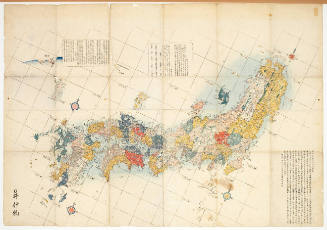
Map of the Japanese Archipelago
Footstool or table
Batsu or Hatsu
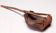
Bailer or Scoop
Knife or Sword
Stand or Container
Plate Or Tray
Book or Album

Plaque or Tray
Teapot (or winepot)

Surcoat or Vest
Eastern Archipelago. Flores and Timor Seas

Southwest Japan (Kyūshū, Shikoku, and southwest Honshū), non-metallic mineral production
![Japan [cartographic material] : ports of greatest shipping activity](https://stacks.stanford.edu/image/iiif/yg817zs3009%2Fyg817zs3009_00_0001/full/!200,200/0/default.jpg)
Japan [cartographic material] : ports of greatest shipping activity

Ube, Yamaguchi Prefecture, Honshū, Japan

Southwest Japan (Kyūshū, Shikoku, and southwest Honshū) machinery production
![Yokohama : [base map showing political divisions]](https://stacks.stanford.edu/image/iiif/hg765ms3579%2Fhg765ms3579_00_0001/full/!200,200/0/default.jpg)
Yokohama : [base map showing political divisions]

Southwest Japan (Kyushu, Shikoku, and Southwest Honshu) : Cities and towns (Shi) : size and functi...
Eastern Archipelago, Arafura Sea. Tanimbar Islands
Eastern Archipelago : Celebes - East Coast. Tg. Losoni to Northern Entrance to Buton Str.
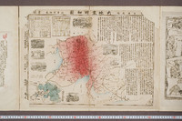
美濃尾張大地震明細図
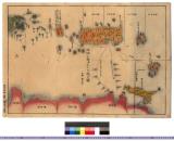
!["Roti"-tō heiyō chishi shiryōzu [cartographic material]](https://stacks.stanford.edu/image/iiif/gk414rt9197%2Fgk414rt9197_00_0001/full/!200,200/0/default.jpg)
"Roti"-tō heiyō chishi shiryōzu [cartographic material]

Jūmanbunnoichi Guamutō fukin

「江戸百景余興」 「鉄炮洲築地門跡」

Japan, Hokushu - South Coast. Uchiura Wan or Iburi Wan (Volcano Bay)
Eastern Archipelago : Flores Sea. Tana Jampea and Adjacent Islands

Celebes - West Coast : Cape William to Tandyung Karang

北海道の観光と交通
東錦絵曽我八景自筆鏡当世自筆鏡

Southwest Japan (Kyūshū, Shikoku, and southwest Honshū), railroads and railroad facilities

Cities of Japan

Japan: Topography and industrial areas
![Japan, radiotelephone and radiotelegraph stations [cartographic material] : 1941](https://stacks.stanford.edu/image/iiif/pp234mp0165%2Fpp234mp0165_00_0001/full/!200,200/0/default.jpg)
Japan, radiotelephone and radiotelegraph stations [cartographic material] : 1941

Southwest Japan (Kyūshū, Shikoku, and southwest Honshū) non-ferrous metals, mines and processing p...
琉球国全図 : 三国通覧図〈付琉球、朝鮮、蝦夷、無人島〉
Last Updated: 2020-04-17
Uploaded: 2021-09-21