
Japan, Gulf of Ösaka, Hiogo and Ösaka compiled from British and French surveys to 1878
- Time
- Owner Organization

Japan : South coast of Honshu : Gulf of Tokyo or Yedo. Compiled from Japanese Government, and Brit...
Stanford University Libraries
Stanford Libraries SearchWorks

Map of Colorado Territory, Compiled from Government Maps & Actual Surveys. Made In 1861
Stanford University Libraries
Stanford Libraries SearchWorks

Map of Colorado Territory, Compiled from Government Maps & Actual Surveys. Made In 1861
Stanford University Libraries
Stanford Libraries SearchWorks

Map of Colorado Territory, Compiled from Government Maps & Actual Surveys. Made In 1861
Stanford University Libraries
Stanford Libraries SearchWorks

Map of Colorado Territory, Compiled from Government Maps & Actual Surveys. Made In 1861
Stanford University Libraries
Stanford Libraries SearchWorks
Japan Islands and eastern coasts of Korea and Siberia from Tsu Sima to Gulf of Tartary : index to Admiralty published charts / Hydrographic Office
National Library of Australia
Trove: National Library of Australia

Ise Bay - North :
Yale University Library
Yale University Library Digital Collections
How the war began : a narrative of events leading to the outbreak of war : from official British and French sources
NDL Digital Collections
NDL Digital Collections
Japan opened compiled chiefly from the narrative of the American expedition to Japan, in the years...
オクスフォード大学ボドリアン図書館サービス
Europeana API

New railway map of Tokyo and vicinity. Published by Japan Guide Map Co., Ltd. Compiled and printed...
Stanford University Libraries
Stanford Libraries SearchWorks

A Correct Map From Actual Surveys And Examinations Embracing A Portion of California Between Monte...
Stanford University Libraries
Stanford Libraries SearchWorks

Stanford's library Map of Japan / principally compiled from japanese documents, by E. Knipping
Bibliothèque nationale de France
Europeana API
![China and Japan [cartographic material] / compiled from G.S.G.S. 4065 and 2957](https://collections.library.yale.edu/iiif/2/15510764/full/!200,200/0/default.jpg)
China and Japan [cartographic material] / compiled from G.S.G.S. 4065 and 2957
Yale University Library
Yale University Library Digital Collections
Sir Robert Craigie,ihe new British Ambassador to Japan, who sailed from England on Wednesday to take up his ...
National Library of New Zealand
DigitalNZ New Zealand API
![Japan and adjacent regions of Asia and the Pacific Ocean [cartographic material] / compiled and drawn in the...](https://collections.library.yale.edu/iiif/2/15510875/full/!200,200/0/default.jpg)
Japan and adjacent regions of Asia and the Pacific Ocean [cartographic material] / compiled and drawn in the...
Yale University Library
Yale University Library Digital Collections
![Japan and adjacent regions of Asia and the Pacific Ocean [cartographic material] / compiled and drawn in the...](https://collections.library.yale.edu/iiif/2/15509964/full/!200,200/0/default.jpg)
Japan and adjacent regions of Asia and the Pacific Ocean [cartographic material] / compiled and drawn in the...
Yale University Library
Yale University Library Digital Collections

Japan and Korea / compiled and drawn in the Cartographic Section of the National Geographic Society ; James ...
Yale University Library
Yale University Library Digital Collections
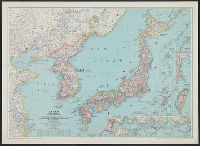
Japan and Korea / compiled and drawn in the Cartographic Section of the National Geographic Society ; James ...
Yale University Library
Yale University Library Digital Collections

Lloyd's Official Map of the State of Tennessee Compiled From Actual Sureys and Official Documents ...
Stanford University Libraries
Stanford Libraries SearchWorks
Chart of the Kuro Siwo or Japan Stream of the Pacific : analogous to the Gulf Stream of the Atlantic, as investigated by the Officers of the U.S. Japan Expedition in 1854
National Library of Australia
Trove: National Library of Australia

Drill of the French and English Troops (Kiheitai hoheitai ōchōren no zu)
Philadelphia Museum of Art
Philadelphia Museum of Art collection

A New and Accurate Map of the World. Drawn from the best Surveys and regulated by Astronomical Obs...
Stanford University Libraries
Stanford Libraries SearchWorks
Nippon (Japan) 1876 : compiled from native maps and the notes of recent travellers / by R. Henry Brunton
National Library of Australia
Trove: National Library of Australia
SCAPIN-1707/4: EXPANSION OF RADIOTELEGRAPH SERVICE FROM JAPAN TO FRENCH INDOCHINA, VIA MANILA 1946/06/08
NDL Digital Collections
NDL Digital Collections
Last Updated: 2020-04-09
Uploaded: 2020-12-17