MAP, OF THE SEAT OF WAR BETWEEN CHINA AND JAPAN; (Auckland Star, 22 September 1894)
- Time
- Owner Organization
Stanford's map of eastern China, Japan and Korea : the seat of war in 1894
HIS FIRST UMBRELLA. A Pround Little Man of Japan (Auckland Star, 05 September 1903)
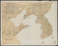
Japan-China War, 1894-5

Special war map of China, Korea, and Japan
Der Krieg zwischen China und Japan 1894/95. 1 Theil, Das Jahr 1894

1904 war map of Japan, Korea, and China

1904 war map of Russia and the continent of Asia

Rand, McNally & Co.'s 1904 war map of Russia and the continent of Asia

The war against Japan (Map USSR, China & Australia)

Album of the Japan-China war 1

Album of the Japan-China War 2
Map of the country between Auckland and the River Waikato, New Zealand, illustrating the war with the natives ; The harbour of Kagosima, Japan / John Dower F.R.G.S. Delt
World War, 1939-1945. Norfolk Island. Map showing dispositions as of September, 1943

Bartholomew's special Map of China, Japan and Korea

Bartholomew's Special Map of China, Japan and Korea
War map : Australia, China, Japan, and the South Pacific / Cyril Dillon
![[Russian Map of Northeastern Asia, Japan, Korea, China, Alaska, etc.] ( Summary map of hydrographi...](https://stacks.stanford.edu/image/iiif/pj697kr2558%2F35405/full/!200,200/0/default.jpg)
[Russian Map of Northeastern Asia, Japan, Korea, China, Alaska, etc.] ( Summary map of hydrographi...

The Senkaku/Diaoyu Islands Territorial Dispute between Japan and China: Between the Materializatio...
Eastern China and Japan, (Evening Post, 22 June 1939)
"Daily Mail" map of the war in China / G. Philip & Son

THE TURMOIL IN THE FAR EAST: LATEST PHOTOGRAPHS FROM SHANGHAI, THE CENTRE OF THE WAR BETWEEN JAPAN AND CHINA

(Composite of) Plates 20, 21, 22, 23. China, Japan, Korea
Der Krieg zwischen China und Japan 1894/95. 3 Theil, Waffenstillstand, operationen gegen Formosa u...

Korean War 1950-1953 -- Asia, North Korea, South Korea, China, Manchuria, Japan Map / Maps.com(CR)
Last Updated:
Uploaded: 2020-12-17