
日本北州西岸後志小樽港 = Japan Hokusyū, west coast, Shiribeshi, Otaru Kō
- Time
- Owner Organization

日本九州西岸肥後三角港 = Japan Kiūshū, west coast, Misumi Harbour
Yoshida-South Library, Kyoto University
IIIF Discovery in Japan

日本本州北西岸伯耆境港 = Japan, Honshū-north west coast, Sakai Harbour
Yoshida-South Library, Kyoto University
IIIF Discovery in Japan

日本本州北西岸若狭小濱港 = Japan Honshū, north west coast, Ohama Harbour
Yoshida-South Library, Kyoto University
IIIF Discovery in Japan

日本九州西岸肥前長崎港 = Japan Kiushū, west coast, Nagasaki Harbour
Yoshida-South Library, Kyoto University
IIIF Discovery in Japan

日本本州南岸志摩的矢港 = Japan, Honshū-south coast, Matoya Harbour
Yoshida-South Library, Kyoto University
IIIF Discovery in Japan

日本本州南岸東京海湾浦賀港 = Japan Honshū, south coast Tōkio gulf Uraga harbour
Yoshida-South Library, Kyoto University
IIIF Discovery in Japan

日本本州北西岸岩瀬及伏木錨地 = Iwase and Fushiki Anchorages at n. w. coast of Honshū-Japan
Yoshida-South Library, Kyoto University
IIIF Discovery in Japan

日本四国南岸土佐浦戸港高知=Japan Shikoku, south coast, Urado Harbour and Kōchi
Yoshida-South Library, Kyoto University
IIIF Discovery in Japan

日本本州北西岸能登七尾湾= Japan Honshū, N. W. coast, Nanao Bay : north bay from survey of Lieutt. K. Kimotski, I. J. N. 12th. Year of Meiji (1879), South Bay, West Bay and the Soundings at outer part of the Bays from survey of commr. K. Isono
Yoshida-South Library, Kyoto University
IIIF Discovery in Japan

日本四国西岸伊豫宇和島湾 = Japan Shikoku, west coast Uwajima Bay surveyed by Lieut.ts S. Aoki, S.Yoshida, I. J. N. 8.th Year of Meiji, (1875), The Parts west of Ōra Zaki and Mizuga Ura enlarged from the survey of Comm.r K. Kimotski, I. J. N
Yoshida-South Library, Kyoto University
IIIF Discovery in Japan

Imizugunbungenezu
Imizu City Shinminato Museum
ADEAC: A System of Digitalization and Exhibition for Archive Collections
Estrecho de Simonoseki. H. 106a :entrada occidentral del Seto-Uchi tomados de los trabajos verific...
Biblioteca Nacional de España
Europeana API
![Gomanbun no ichi Chishima rettō rikukai hengōzu [cartographic material]](https://stacks.stanford.edu/image/iiif/hb691zk3905%2Fhb691zk3905_00_0001/full/!200,200/0/default.jpg)
Gomanbun no ichi Chishima rettō rikukai hengōzu [cartographic material]
Stanford University Libraries
Stanford Libraries SearchWorks

岐阜県管内図
Takayamashi Kyoiku Iinkai
ADEAC: A System of Digitalization and Exhibition for Archive Collections

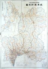
大日本帝國中部地形圖
Yoshida-South Library, Kyoto University
IIIF Discovery in Japan

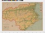
阿州全図
Tokushima Prefectural Archives
ADEAC: A System of Digitalization and Exhibition for Archive Collections

Strategical map of part of Korea and Manchuria / prepared by the Second Division, General Staff (Military In...
Yale University Library
Yale University Library Digital Collections
![[歴民カード_歴史] 叡山図](https://khirin-i.rekihaku.ac.jp/iiif/nmjh_rekimin_h/12548185_02.tif/full/200,/0/default.jpg)
[歴民カード_歴史] 叡山図
National Museum of Japanese History
IIIF Discovery in Japan

Nomigunbungenezu
Imizu City Shinminato Museum
ADEAC: A System of Digitalization and Exhibition for Archive Collections
![[雲陽十郡絵図]](https://da.lib.shimane-u.ac.jp/image/open/2109987/1.tif/full/200,/0/default.jpg)
[雲陽十郡絵図]
Shimane University Library Digital Archive Collection
IIIF Discovery in Japan
日本本州北西岸岩瀬及伏木錨地 = Iwase and Fushiki Anchorages at n. w. coast of Honshū-Japan
Yoshida-South Library, Kyoto University
IIIF Discovery in Japan
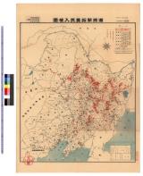
満洲開拓農民入植図 : 満洲開拓農民入植図
Iwase Bunko Libray
ADEAC: A System of Digitalization and Exhibition for Archive Collections
岐阜県新地図
Takayamashi Kyoiku Iinkai
ADEAC: A System of Digitalization and Exhibition for Archive Collections
日本本州南岸東京海湾浦賀港 = Japan Honshū, south coast Tōkio gulf Uraga harbour
Yoshida-South Library, Kyoto University
IIIF Discovery in Japan

朝鮮總圖 = General map of Chosen (Korea)
Yoshida-South Library, Kyoto University
IIIF Discovery in Japan
Kūchū shashin sokuryō yōzu Sumatora gomanbun no ichi zu: シデイギナン (Sheet 6亻176-53)
National Library of Australia
Trove: National Library of Australia
徳島県日本新分県地図
Tokushima Prefectural Archives
ADEAC: A System of Digitalization and Exhibition for Archive Collections
Last Updated: 2020-04-16
Uploaded: 2021-07-27