

Kaikoku zenzu

Kaikoku zenzu

Kaikoku zenzu

Kaikoku zenzu

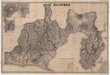
Yamanashiken kaikoku zenzu

Kaikoku ezu

Nendai kijun kaikoku shikai

Koufushi zenzu

Koufushi zenzu

Koufushi zenzu

Koufushi zenzu

Koufushi zenzu

Koufushi zenzu

Koufushi zenzu

Koufushi zenzu

Koufushi zenzu

Koufushi zenzu

Koufushi zenzu

Koufushi zenzu

Koufushi zenzu

Koufu shigai zenzu

Koufu shigai zenzu

Koufu shigai zenzu

Koufu shigai zenzu
Kaikoku zenzu
Kaikoku zenzu
Kaikoku zenzu
Kaikoku zenzu

Taifuu nanagou ni yoru yamanashi kenka no shuyou saigai zu

「〔箱根絵図〕」
静岡県管内全図 : 静岡県管内全図
Koufushi zenzu
Asiae nova descriptio / auctore Jodoco Hondio
The Mountains of Husband and Wife
Asia with the islands adioyning described, the atire of the people & townes of importance, all of them newly augmented by I.S. Ano dom. 1626 / Sculptum apud Abrahamum Goos

「こく町 佐藤屋」
Pas-caert van't Oostelyckste deel van Oost Indien : met alle de Eylanden daer onder gelegen, van Cabo Comorin tot aen Japan / by Hendrick Doncker Boekverkooper en Graadbooghmaacker Inde Nieuwbrughsteegh

「武州金沢擲筆山地蔵院能見堂八景之画図」
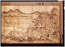
楼閣山水図屏風
To the Right Honourable William, Lord Cowper, Lord High Chancellor of Great Britain, this map of Asia : according to ye newest and most exact observations is most humbly dedicated / by your Lordship's most humble servant, Herman Moll, geographer

Yamanashiken kannai zenzu
A new map of India & China from the latest observations / by I. Senex
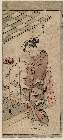
「九月(右)」
Asia divided into its principall regions in which may be seen the extent of the empires, monarchies, kingdoms and states which at present divide Asia / described by Sanson ; corrected and amended by William Berry

「大阪下り縮緬さいく」 「縮緬さいく」

「安芸厳島神社之図」
Tokyo and vicinity : showing bombed-out areas / prepared ... by Nippon Map Co
Tabula Tartariae et majoris partis regni Chinae / edita a F. de Wit ; Lhuilier fecit
Uploaded: 2026-02-25