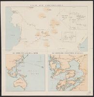
Unzen and neighbourhood
- Time
- Owner Organization

Mount Unzen
Freer and Sackler
DPLA API
Map and guide of Hakone and neighbourhood
Yale University Library
Yale University Library Digital Collections

Mount Unzen, Hizen (Hizen Unzendake)
Art Institute of Chicago
Art Institute of Chicago API

Mount Unzen, Hizen (Hizen Unzendake)
Art Institute of Chicago
Art Institute of Chicago API

Mount Unzen (Unzen Ikkei), series 100 New Scenes of Japan
Honolulu Museum of Art
Honolulu Museum of Art Collection

Mount Unzen seen from Amakusa
Freer and Sackler
DPLA API

Mt. Unzen- Shimabara Hanō Series
Honolulu Museum of Art
Honolulu Museum of Art Collection

Gezicht op de warmwaterbronnen van Kojigoku Unzen
Rijksmuseum
Rikijmuseum API

Mount Unzen, Hizen, from the series Collection of Ukiyo-e designs
Freer and Sackler
DPLA API

Viscous flow of magmas from Unzen volcano, Japan :implication for magma mixing and ascent = Visko...
German National Library
Europeana API

Extraordinary European Council on EU Southern Neighbourhood and Libya and meeting of the Heads of ...
Audiovisual Library of the European Commission
Europeana API

The Guide Map to the Railway in The Neighbourhood of Tokyo
Stanford University Libraries
Stanford Libraries SearchWorks
![barber from "“Our Neighbourhood”; or, Sketches in the Suburbs of Yedo. By T. A. P[urcell]"](https://api.europeana.eu/api/v2/thumbnail-by-url.json?uri=http%3A%2F%2Ffarm6.staticflickr.com%2F5500%2F11107123655_766a406376_o.jpg&type=IMAGE)
barber from "“Our Neighbourhood”; or, Sketches in the Suburbs of Yedo. By T. A. P[urcell]"
British Library
Europeana API
![Yedo from "“Our Neighbourhood”; or, Sketches in the Suburbs of Yedo. By T. A. P[urcell]"](https://api.europeana.eu/api/v2/thumbnail-by-url.json?uri=http%3A%2F%2Ffarm4.staticflickr.com%2F3799%2F11104571306_087a5482a6_o.jpg&type=IMAGE)
Yedo from "“Our Neighbourhood”; or, Sketches in the Suburbs of Yedo. By T. A. P[urcell]"
British Library
Europeana API
![cemetery from "“Our Neighbourhood”; or, Sketches in the Suburbs of Yedo. By T. A. P[urcell]"](https://api.europeana.eu/api/v2/thumbnail-by-url.json?uri=http%3A%2F%2Ffarm4.staticflickr.com%2F3781%2F11107340436_99d5ca62b8_o.jpg&type=IMAGE)
cemetery from "“Our Neighbourhood”; or, Sketches in the Suburbs of Yedo. By T. A. P[urcell]"
British Library
Europeana API
![flute player from "“Our Neighbourhood”; or, Sketches in the Suburbs of Yedo. By T. A. P[urcell]"](https://api.europeana.eu/api/v2/thumbnail-by-url.json?uri=http%3A%2F%2Ffarm3.staticflickr.com%2F2854%2F11103861683_a0235be0f8_o.jpg&type=IMAGE)
flute player from "“Our Neighbourhood”; or, Sketches in the Suburbs of Yedo. By T. A. P[urcell]"
British Library
Europeana API

Unzen ikkei (Object); Shin Nihon hyakkei (Series)
British Museum
British Museum Collection

Dragon and clouds
Freer and Sackler
DPLA API

Dragons and Clouds
Freer and Sackler
DPLA API

Dragons and Clouds
Freer and Sackler
DPLA API
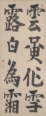
Clouds and Dew
Minneapolis Institute of Arts
Minneapolis Institute of Art API

Dragon and Clouds
Freer and Sackler
DPLA API
Dragon and Clouds
Harvard Art Museums
Harvard Art Museums API

Mountains and clouds
Israel Museum
Europeana API
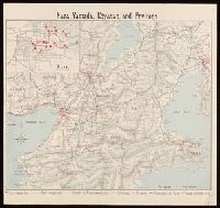
Nara, Yamada, Koyasan, & environs
Yale University Library
Yale University Library Digital Collections

Japan and it's relation to the territory bordering on the Pacific ocean
Yale University Library
Yale University Library Digital Collections

Nara, Yamada, Koyasan, & environs
Yale University Library
Yale University Library Digital Collections

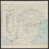
Nagasaki
Yale University Library
Yale University Library Digital Collections

Japan electric power / drawn and reproduced by Co B, 942nd Engr. Avn. Topo. Bn, 325th Ric., US Army
Yale University Library
Yale University Library Digital Collections
![[2 Maps of Korea:] Karte von der Koraischen Halbinsel... Nach einem japanischen Originale. 1840 [a...](https://stacks.stanford.edu/image/iiif/qt462tg9589%2F34409/full/!200,200/0/default.jpg)
[2 Maps of Korea:] Karte von der Koraischen Halbinsel... Nach einem japanischen Originale. 1840 [a...
Stanford University Libraries
Stanford Libraries SearchWorks

亜細亜東部略図
Saga Prefectual Library
IIIF Discovery in Japan
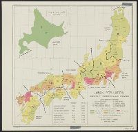
Japan: population densities by prefectures and province
Yale University Library
Yale University Library Digital Collections
ōiso, 9th of 53 Stations of the Tōkaidō (Tōkaidō gojūsan-tsugi no uchi: ōiso)
Harvard Art Museums
Harvard Art Museums API
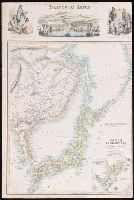
China Divided into its Great Provinces and the Isles of Japan [Material cartográfico]
Biblioteca Nacional de España
Europeana API

The Japanese empire : with central and southern Manchukuo (Manchuria)
Yale University Library
Yale University Library Digital Collections
![Japan, Yamaguchi-ken [cartographic material]](https://stacks.stanford.edu/image/iiif/zc849tw9296%2Fzc849tw9296_00_0001/full/!200,200/0/default.jpg)
Japan, Yamaguchi-ken [cartographic material]
Stanford University Libraries
Stanford Libraries SearchWorks

大日本帝國西南部地形圖
Yoshida-South Library, Kyoto University
IIIF Discovery in Japan
Träsnitt, Bildkonst, Woodblock, Print, Woodcut
Museum of Far Eastern Antiquities, Stockholm
Europeana API
Islands of Japan
Yale University Library
Yale University Library Digital Collections
Peaches in Buryō (illustration and text) (Buryō Tōgen)
Honolulu Museum of Art
Honolulu Museum of Art Collection
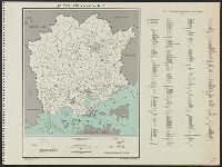
Japan. Okayama-ken : administrative divisions, November 1943 / G.P.O. - Department of State Service Office
Yale University Library
Yale University Library Digital Collections

Lustgarten des Shugakuin-Tempels, Kyoto
Architekturmuseum der TU Berlin
Europeana API

General map of China and adjacent regions showing treaty ports and railroads / prepared for the Department o...
Yale University Library
Yale University Library Digital Collections
![Dîner Dentu [...] des célébrités contemporaines : [estampe] (Epr. de la pl. de rouge) / H. G., [He...](https://api.europeana.eu/thumbnail/v2/url.json?uri=https%3A%2F%2Fgallica.bnf.fr%2Fiiif%2Fark%3A%2F12148%2Fbtv1b10531553m%2Ff1%2Ffull%2F512%2C%2F0%2Fnative.jpg&type=IMAGE)
Dîner Dentu [...] des célébrités contemporaines : [estampe] (Epr. de la pl. de rouge) / H. G., [He...
Bibliothèque nationale de France
Europeana API

Japan : to illustrate the paper by Ellen Churchill Semple.
Yale University Library
Yale University Library Digital Collections
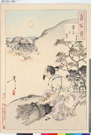
Tsukinohyakushi
Tokyo Metropolitan Central Library
ARC Ukiyo-e Portal Database
Japan / by J.G. Bartholomew, F.R.G.S
National Library of Australia
Trove: National Library of Australia
Rekiishi, series Famous Views of Owari Province
Honolulu Museum of Art
Honolulu Museum of Art Collection
Last Updated: 2021-01-30
Uploaded: 2021-07-29