Japan road map 1:1,000,000. sheet 4, Korea / prepared under the direction of the Chief of Engineers, U.S. Ar...
- Time
- Owner Organization

Japan road map, 1:1,000,000 / prepared under the direction of the Chief of Engineers, U.S. Army by the Army ...
Series ; 5207
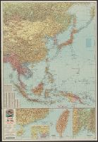
East Asia and North Pacific 1:4,350,000 / prepared under the direction of the Chief of Engineers by the Army Map Service (AM) ; U.S. Army, Washington, D.C
Central Japan 1:500,000 / prepared under the direction of the Engineer, U.S. Sixth Army, AFPAC, by the 650th Engineer TOP. BN., August 1945
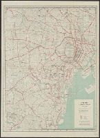
City map, central Tokyo. December 1946 / prepared under direction of the chief engineer, general headquarter...
City map, central Tokyo. October 1947 / prepared under direction of the chief engineer, GHQ, FEC, byt the 64...
Japan 1:500,000 / prepared under the direction of the Engineer, U.S. Sixth Army by the 69th EngineerTopo. Co., July 1945 ; reproduced by BMP no 1, GHQ. AFPAC, U.S. Army
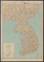
Korea / prepared ... by the Army Map Service, U.S. Army
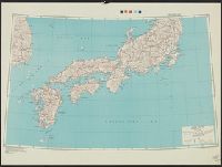
Japan / prepared by the Army Map Service, (GD) Corps of Engineers, U.S. Army
Handbook to the colony of Victoria / prepared under the direction of the Victorian Government by Henry Heylyn Hayter
The story of Japanese farming in California. Prepared under the direction of Emil T. H. Bunje. Ber...
The story of Japanese farming in California. Prepared under the direction of Emil T. H. Bunje. Ber...
City map, central Tokyo / prepared under the direction of the Engineer, GHQ, FEC ; by the 64th Engineer Base Topographic Battalion
JAPANESE MILITARY ENGINEERS CONSTRUCTING A ROUGH TIMBER ROAD FOR THE TROOPS IN KOREA. The success of the Kor...
City map, central Tokyo / prepared under the direction of Office of the Engineer, HQ, AFFE, by the 64th Engineer Battalion (Base Topographic)
Caroline Islands 1:25,000 : Yap / prepared under the direction of Engineer, Hq AFFE/BA, by the Military Geology Branch, Intelligence Division ; map compiled by C. G. Johnson, geologist, Military Geology Branch, U.S. Geological Survey, for the Intelligence Division, Office of the Engineer, Hq. U.S. Army Japan
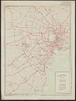
Yokohama city map : corrected to May 1954 / prepared under the direction of Office of the Engineer, AFFE, by the 29th Engineer Battalion (Base Topographic)
AAF cloth chart ; no. C-52, C-53
Japan and South China Seas / prepared at the direction of the commanding general, Army Air Forces, for the A...
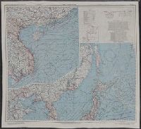
Japan and South China Seas / prepared at the direction of the commanding general, Army Air Forces, for the A...
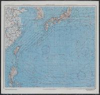
East China Sea

East China Sea
General map of China and adjacent regions, showing treaty ports and railways / prepared for the Department of State, by the Topographic Branch, U.S. Geological Survey
Chart of the world shewing the track of the U.S. steam frigates Mississippi, Susquehanna and Powhatan as flagships of the Japan Squadron under the command of Commodore M.C. Perry U.S.N. 1853-54 / drawn by Edw. Sels ; engr. by Selmar Siebert

Nagasaki

Map of Chosen (Korea)

The Japanese empire : with central and southern Manchukuo (Manchuria)

Rand, McNally & Co.'s 1904 war map of Russia and the continent of Asia
Korea / prepared ... by the Army Map Service, U.S. Army
AAF cloth chart ; no. C-52, C-53
![Japan and adjacent regions of Asia and the Pacific Ocean [cartographic material] / compiled and drawn in the...](https://collections.library.yale.edu/iiif/2/15510875/full/!200,200/0/default.jpg)
Japan and adjacent regions of Asia and the Pacific Ocean [cartographic material] / compiled and drawn in the...

千葉県全図

The Japanese empire : with central and southern Manchukuo (Manchuria)

Mandchourie et Coree de Kharbine a Seoul de Port-Arthur a Vladivostok Traduction de la Carte d'Eta...
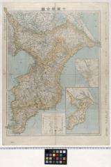
千葉県全図
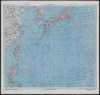
East China Sea

Japan : to illustrate the paper by Ellen Churchill Semple.
East China Sea

大日本帝國西南部地形圖
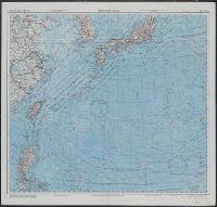
Japan and South China Seas / prepared at the direction of the commanding general, Army Air Forces, for the A...

Bartholomew's special Map of China, Japan and Korea

Japan and Korea / compiled and drawn in the Cartographic Section of the National Geographic Society ; James ...
![Indo oyobi Seia [cartographic material] : Roppyakmanbun no ichi](https://stacks.stanford.edu/image/iiif/dx650yf2686%2Fdx650yf2686_00_0001/full/!200,200/0/default.jpg)
Indo oyobi Seia [cartographic material] : Roppyakmanbun no ichi
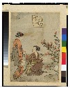
俊頼・萩の玉川 「近江の名所」「萩の玉川」
Theater of war in the Pacific Ocean / compiled and drawn in the Cartographic Section of the National Geographic Society for the National Geographic Magazine
![[Carte de l'Asie]. 2, Seconde partie : la Chine et partie de la Tartarie, l'Inde au delà du Gange,...](https://api.europeana.eu/api/v2/thumbnail-by-url.json?uri=http%3A%2F%2Fgallica.bnf.fr%2Fark%3A%2F12148%2Fbtv1b530526032.thumbnail.jpg&type=IMAGE)
[Carte de l'Asie]. 2, Seconde partie : la Chine et partie de la Tartarie, l'Inde au delà du Gange,...

Ise Bay - North :
Esso war map III featuring the Pacific Theater : a third war map / edited, drafted and printed by the makers...
Last Updated: 2021-01-30
Uploaded: 2021-07-29