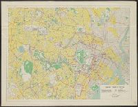
Map of central Tokyo / prepared for the 64th Engineer Topographic Battalion for GHQ Visitors Bureau
- Time
- Owner Organization
City map, central Tokyo / prepared under the direction of the Engineer, GHQ, FEC ; by the 64th Engineer Base Topographic Battalion
City map, central Tokyo / prepared under the direction of Office of the Engineer, HQ, AFFE, by the 64th Engineer Battalion (Base Topographic)
City map, central Tokyo. October 1947 / prepared under direction of the chief engineer, GHQ, FEC, byt the 64...
City map, central Tokyo. December 1946 / prepared under direction of the chief engineer, general headquarter...
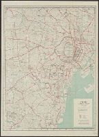
Yokohama city map : corrected to May 1954 / prepared under the direction of Office of the Engineer, AFFE, by the 29th Engineer Battalion (Base Topographic)
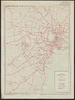
Tokyo city bus routes : June, 1948 / compiled and reproduced by the 64th Engineer Base Topographic Bn
Central Japan 1:500,000 / prepared under the direction of the Engineer, U.S. Sixth Army, AFPAC, by the 650th Engineer TOP. BN., August 1945
Tokyo and vicinity : showing bombed-out areas / prepared ... by Nippon Map Co
General map of China and adjacent regions, showing treaty ports and railways / prepared for the Department of State, by the Topographic Branch, U.S. Geological Survey
Special map : Haha Jima / prepared for CinCPac-CinCPOA by 64th Engr. Top. Bn. USAFCPBC, Dec. 1944 ; reproduced by 30th Engr. Base Top. Bn. USAFCPBC No. 1337-1, February 1945
Special map : Muko Jima / prepared for CinCPac-CinCPOA by 64th Engr. Top. Bn. USAFCPBC, No. 1157 Jan. 1945 ; reproduced by 30th Engr. Base Top. Bn. USAFCPBC No. 1340-1, February 1945
Japan 1:500,000 / prepared under the direction of the Engineer, U.S. Sixth Army by the 69th EngineerTopo. Co., July 1945 ; reproduced by BMP no 1, GHQ. AFPAC, U.S. Army
Gouvt. Groote Oost. Res. Molukken (Nieuw-Guinea) Division Great East Residency Moluccas (New Guinea) / prepared and reproduced by Base Map Plant, USASOS, SWPA ... from Dutch map printed by Topografische Dienst (Topographic Service)
Caroline Islands 1:25,000 : Yap / prepared under the direction of Engineer, Hq AFFE/BA, by the Military Geology Branch, Intelligence Division ; map compiled by C. G. Johnson, geologist, Military Geology Branch, U.S. Geological Survey, for the Intelligence Division, Office of the Engineer, Hq. U.S. Army Japan

General map of China and adjacent regions showing treaty ports and railroads / prepared for the Department o...

Tomano, Okayama and Kagawa Prefectures, Honshu, Japan
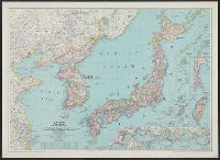
Japan and Korea / compiled and drawn in the Cartographic Section of the National Geographic Society ; James ...

Kudamatsu, Yamaguchi Prefecture, Honshu, Japan

Toyohashi, Aichi Prefecture, Honshū, Japan
![Suirobu Hi [Kaizu]](https://stacks.stanford.edu/image/iiif/nm634np1065%2Fnm634np1065_0001/full/!200,200/0/default.jpg)
Suirobu Hi [Kaizu]

Nagoya, Aichi-ken, Honshū, Japan

Kamaishi, Iwate Prefecture, Honshu, Japan

Tokyo city plan

Miyakonojo, Miyazaki Prefecture, Kyushu, Japan

Kochi, Kochi Prefecture, Shikoku, Japan
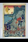
「末広五十三次」 「興津」

Tsuyama, Okayama Prefecture, Honshu, Japan
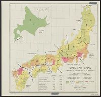
Japan: population densities by prefectures and province

北海道の観光と交通
Japan / by J.G. Bartholomew, F.R.G.S

「末広五十三次」 「吉原」

Asie Orientale comprenant L'Empire Chinois et le Japon Les Etats De L'Indo-Chine et le Grand Archi...

Tsuruga, Fukui Prefecture, Honshu, Japan

Koriyama, Fukushima Prefecture, Honshu, Japan

Rustende mannen

徳島市街全図
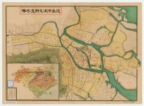
徳島市街及び附近名勝

Yokohama and Vicinity

Suita, Osaka Prefecture, Honshu, Japan
Last Updated: 2021-01-30
Uploaded: 2021-07-29