![[Map of Marinduque, Philippines, in Japanese.]](https://collections.library.yale.edu/iiif/2/15251559/full/!200,200/0/default.jpg)
[Map of Marinduque, Philippines, in Japanese.]
- Time
- Owner Organization
![[Map of part of Samar, Philippines, in Japanese.]](https://collections.library.yale.edu/iiif/2/15251561/full/!200,200/0/default.jpg)
[Map of part of Samar, Philippines, in Japanese.]
Yale University Library
Yale University Library Digital Collections
![[4 maps of Luzon, Philippines, in Japanese.]](https://collections.library.yale.edu/iiif/2/15251546/full/!200,200/0/default.jpg)
[4 maps of Luzon, Philippines, in Japanese.]
Yale University Library
Yale University Library Digital Collections
![[3 maps of Leyte Island, Philippines, in Japanese.]](https://collections.library.yale.edu/iiif/2/15251299/full/!200,200/0/default.jpg)
[3 maps of Leyte Island, Philippines, in Japanese.]
Yale University Library
Yale University Library Digital Collections
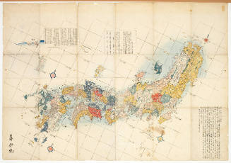
Map of the Japanese Archipelago
Honolulu Museum of Art
Honolulu Museum of Art Collection

Map of Japanese Homeland Island
Philadelphia Museum of Art
Philadelphia Museum of Art collection

Map of the Japanese telegraph system
Boston Public Library
DPLA API
![[Taisho Japanese map of the world. Taisho Japanese map of Japan and Korea]. [9 insets].](https://stacks.stanford.edu/image/iiif/yj892bp5625%2F11670000/full/!200,200/0/default.jpg)
[Taisho Japanese map of the world. Taisho Japanese map of Japan and Korea]. [9 insets].
Stanford University Libraries
Stanford Libraries SearchWorks
[Japanese map of World War ll]
National Library of Australia
Trove: National Library of Australia
[Japanese map of World War II]
National Library of Australia
Trove: National Library of Australia

Dai Nihon zenzu (The picture of the Great Whole Map of Japan; Provinces in the Japanese Empire, in...
Stanford University Libraries
Stanford Libraries SearchWorks

CAPITAL OF THE PHILIPPINES RUTHLESSLY BOMBED BY JAPANESE
Auckland Libraries
DigitalNZ New Zealand API

Map of the Empire of Japan in 1914
New Zealand Ministry for Culture and Heritage
DigitalNZ New Zealand API

Map of Northern Japan. Map of Southern Japan
Bibliothèque nationale de France
Europeana API

Russo-Japanese war map
Bibliothèque nationale de France
Europeana API

WAR PICTURES FROM THE PHILIPPINES: RUTHLESS JAPANESE BOMBENG OF MANILA
Auckland Libraries
DigitalNZ New Zealand API

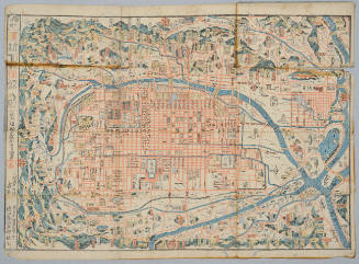
Map of Tokio
Yale University Library
Yale University Library Digital Collections

Map of the Great Japanese Empire (Dainihon Kokugun Yochi Zenzu)
Honolulu Museum of Art
Honolulu Museum of Art Collection
Japanese map plate, Chizuzara
National Gallery of Victoria
Trove: National Library of Australia

WRITHING IN VAIN: JAPANESE AIRCRAFT-CARRIERS SUNK OFF THE PHILIPPINES IN OCTOBER, 1944
Auckland Libraries
DigitalNZ New Zealand API

Map of Japan
Boston Public Library
DPLA API
Map of Kyoto
Honolulu Museum of Art
Honolulu Museum of Art Collection
[Map of Kyoto]
National Library of Australia
Trove: National Library of Australia
![[Map of Kyoto]](https://collections.library.yale.edu/iiif/2/15510884/full/!200,200/0/default.jpg)
[Map of Kyoto]
Yale University Library
Yale University Library Digital Collections

Map of Japan
Stanford University Libraries
Stanford Libraries SearchWorks
[4 maps of Luzon, Philippines, in Japanese.]
Yale University Library
Yale University Library Digital Collections
Kinshū hantō fukin [chizu]: 金城廳 [Kinchūchō] (Sheet 6)
National Library of Australia
Trove: National Library of Australia
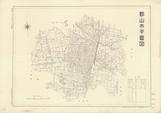
郡山市平面図 昭和28年
Koriyama City Library
ADEAC: A System of Digitalization and Exhibition for Archive Collections
Plan Porta Loĭda (Ostrova Bonin) sni︠a︡tyĭ i sostavlennyĭ Leitenantom Zavalishinym i Michmanom Glazenappom = Plan du Port de Lloyd (Iles Bonine) / leve et dresse par Mr. Zavalichine Lieutenant de Vaisseau et Mr. Glasenapp Enseigne de Vaisseau
National Library of Australia
Trove: National Library of Australia

Shiberia jūmanbun no ichizu Urajiosutoku
Stanford University Libraries
Stanford Libraries SearchWorks
Dai ni-gun no heitan : Meiji sanjūnana-nen hachi-gatsu jūichi nichi
National Library of Australia
Trove: National Library of Australia

Playing go
Library of Congress
Digital Collections, Library of Congress

Carte des decouvertes au nord du Japon. Faites en 1643 par les Vaisseaux Hollandais le Kastrikum e...
Stanford University Libraries
Stanford Libraries SearchWorks

Empire of Japan. (with) Nagasaki Harbour. Engraved by J. & C. Walker. Published under the superint...
Stanford University Libraries
Stanford Libraries SearchWorks
![America Bay [cartographic material]](https://stacks.stanford.edu/image/iiif/nj035cf2832%2Fnj035cf2832_00_0001/full/!200,200/0/default.jpg)
America Bay [cartographic material]
Stanford University Libraries
Stanford Libraries SearchWorks

「生花」「秋草 他」
Tokyo Metropolitan Central Library
ARC Ukiyo-e Portal Database
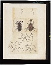
昆虫写生帖
Tokyo National Museum
ARC Ukiyo-e Portal Database

Rock & bamboo in garden
Library of Congress
Digital Collections, Library of Congress

Carte des decouvertes, faites en 1787 dans les mers de Chine et de Tartarie par les Fregates Franc...
Stanford University Libraries
Stanford Libraries SearchWorks

Carte des découvertes au Nord du Japon faites en 1643 par les vaisseaux hollandais le Kastrikum et...
Bibliothèque nationale de France
Europeana API

Karisei Shōkakō oyobi Raringa ryūiki gomanbun no ichizu
Stanford University Libraries
Stanford Libraries SearchWorks

Taiwan oyobi Rusontō. Hyakumanbun no ichi kōkūzu
Stanford University Libraries
Stanford Libraries SearchWorks
Kūchū shashin yōzu Sanman Gosen bun no ichi Bisumaruku Guntō (sheet 1)
National Library of Australia
Trove: National Library of Australia

滿洲歴史地理. : 第壹巻附図 : 前漢時代満洲図 西紀二〇二-西紀二五年
Yoshida-South Library, Kyoto University
IIIF Discovery in Japan

Motor road network, Japan
Stanford University Libraries
Stanford Libraries SearchWorks
Ranyō Nyūginia zenzu
National Library of Australia
Trove: National Library of Australia

Empire of Japan, Yedo ... Meaco. (insets) Nagasaki Harbour. Eastern Point of Yeso
Stanford University Libraries
Stanford Libraries SearchWorks

滿洲歴史地理. : 第壹巻附図 : 後魏時代満洲図 (439-550)
Yoshida-South Library, Kyoto University
IIIF Discovery in Japan
「六歌仙」
Mario Marega Collections, Salesian University, Rome
ARC Ukiyo-e Portal Database
Last Updated: 2021-01-30
Uploaded: 2021-07-29