A new map of India & China from the latest observations / by I. Senex
- People
- Time
- Owner Organization

A New Map of India & China From the latest Observations

A New Map of Asia from the latest Observations Most Humbly Inscrib'd to the Right Honbl. George Ea...

A New Map of Asia from the latest Observations Most Humbly Inscrib'd to the Right Honbl. George Ea...

A New Map of Chines & Independent Tartary, From The Latest Authorities . . . 1806

A New Map of Chinese & Independent Tartary, From The Latest Authorities . . . 1806

A New Map of Chinese & Independent Tartary, From The Latest Authorities . . . 1806

A New Map of Chinese & Independent Tartary, From The Latest Authorities . . . 1811

Map of China And the Surrounding Regions. Compiled from the latest information by E. Bretscheider....

A New Map of the Whole World According To The New Observations by Moll Geographer
A map of South China, scene of the latest military operations by the Japanese. , (Evening Post, 13 October 1...
A new map of the empires, states, provinces &c of Asia : including also the Turkish & Russian dominions in Europe & New Holland / compiled from the most authentic observations by Robert Wilkinson ; Walsh script. ; W. Palmer sculpt

A New and Accurate Map of the World. Drawn from the best Surveys and regulated by Astronomical Obs...

A New Map of Great Tartary and China, with the adjoyning Parts of Asia, Taken from Mr. De Fer's Ma...

A New Map of Great Tartary and China, with the adjoyning Parts of Asia, Taken from Mr. De Fer's Ma...

A New Map of Great Tartary and China, with the adjoyning Parts of Asia, Taken from Mr. De Fer's Ma...

A New Map of Great Tartary and China, with the adjoyning Parts of Asia, Taken from Mr. De Fer's Ma...

New map of Shanghai. (on verso) A map of China : Published by K. Saito. Osaka Japan Sole agent T. ...

CHINA IN THE GRIP OF WAR: LATEST PICTURES FROM THE SHANGHAI ZONE OF THE SINOJAPANESE CONFLICT

The latest map of Manchuria, Korea, Formosa, and Saghalien

Map of Asia

Stanford's map of China and Japan with the adjacents parts of the Russian Rebubcs., India, Burma &...

THE TURMOIL IN THE FAR EAST: LATEST PHOTOGRAPHS FROM SHANGHAI, THE CENTRE OF THE WAR BETWEEN JAPAN AND CHINA
The country trade East-India pilot, for the navigation of the East-Indies and oriental seas, within the limits of the East-India Company, extending from the Cape of Good Hope to China, New Holland and New Zeeland, with the Red Sea, Gulf of Persia, Bay of Bengal, and China Seas / chiefly composed from actual surveys and draughts communicated by experienced officers of the East-India Company, and from the Neptune oriental by M. d'Apres de Mannevillette
Stanford's map of China & Japan with the adjacent parts of the Russian Repubcs. India, Burma &c / Stanford's Geographical Establishment
L'empire de la Chine : d'après l'atlas Chinois, avec les isles du Japon / par M. Bonne, Membre de la Societʹe Litteraire Militre. Ingenieur Gʹeographe &c

Carte Des Indes et de la Chine Dressee sur plusieurs Relations particulieres Rectifees par quelque...
Le isole del Giappone e la Corea : delineate sulle ultime osservazioni / Gio. Ma. Cassini, som inc
Asia and its several islands and regions : according to their most approved divisions with Captain Cooks new discoveries / by Thomas Kitchin, Hydrographer to His Majesty
Asia with the islands adioyning described, the atire of the people & townes of importance, all of them newly augmented by I.S. Ano dom. 1626 / Sculptum apud Abrahamum Goos
A new & accurate map of Asia : drawn from the most approved modern maps & charts / by Thos. Bowen ; engraved for Middletons complete system of geography
Pas-caert van't Oostelyckste deel van Oost Indien : met alle de Eylanden daer onder gelegen, van Cabo Comorin tot aen Japan / by Hendrick Doncker Boekverkooper en Graadbooghmaacker Inde Nieuwbrughsteegh
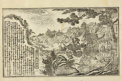
![[Scenes related to the Soga family - two warriors with swords walking behind retainers leading two horses]](https://tile.loc.gov/storage-services/service/pnp/jpd/02500/02587_150px.jpg)
[Scenes related to the Soga family - two warriors with swords walking behind retainers leading two horses]

Descripcao nova, e exacta dos Reynos, e Provincias do Japao

Tabula Geodoborica Itinerum a Varijs in Cataium susceptorum rationem exhibens (Kircher's map of hi...

(Composite Map of) Map of the Island of Japan, Kurile &c. with the Adjacent Coasts of the Chinese ...
Carte générale de l'empire Chinois et du Japon / par A. H. Brué, géographe de S.A.R. Monsieur ; gravée sous la direction de l'auteur
![[Lovers in an autumn meadow]](https://tile.loc.gov/storage-services/service/pnp/jpd/02100/02139_150px.jpg)
[Lovers in an autumn meadow]

L'Empire de la Chine avec les isles du Japon. A Paris, ches Lattre, rue St. Jacq. (ca. 1800)

Maris Pacifici quod vulgo Mar del Zud

「成相山眺望橋立之図」

Mappemonde ou Carte Reduite Des Parties Connues Du Globe Pour servir au Voyage de La Perouse …. 17...
「猪の子餅の由来」

風流雪の遊_三枚続

「安房国鋸山日本寺図」
A New Map of Great Tartary and China, with the adjoyning Parts of Asia, Taken from Mr. De Fer's Ma...
Imperii Sinarum nova descriptio [Martino Martini]
Asia divided into its principall regions in which may be seen the extent of the empires, monarchies, kingdoms and states which at present divide Asia / described by Sanson ; corrected and amended by William Berry

Il Regno Della China detto presentamente Catay e Mangin . . . 1682
Last Updated: 2020-06-05
Uploaded: 2021-07-22