
Chart of the coast of China and of the Japan islands including the Marianes and part of the Philippines

(Chart of Sulphur Island and vicinity). (with) View of Sulphur Island bearing E.N.E. Harmar scr. (...

Charts, etc

Asia, Japan and Korea : with the surrounding seas and the adjacent coastal region of China / published at Wa...

Chart of Discoveries made in 1787 In the Seas of China and Tartary between Manilla and Avateha by ...

Chart of Discoveries made in 1787, in the Seas of China and Tartary, by the Boussole and Astrolabe...

Japanese acupuncture chart

Japanese acupuncture chart

Chart of the Discoveries made in 1787, in the Seas of China and Tartary by the Boussole and Astrol...

North West Pacific Ocean : Including Yellow, Japan & Okhotsk Seas, the Kuril Islands and Kamchatka

Chart of Discoveries, Made in 1787, in the Seas of China and Tartary, by the Boussole and Astrolab...

Sketch of a voyage to the India and China seas, including Japan and the Pacific islands, for the p...

Acu-moxa chart: points of the thorax and abdomen, Japanese

Acu-moxa chart: Heart channel of hand shaoyin, Japanese

Descriptions of some of the new marine invertebrata from the Chinese and Japanese Seas /
Descriptions of some of the new marine invertebrata from the Chinese and Japanese Seas /

Acu-moxa chart: Stomach channel of foot yangming, Japanese

Acu-moxa chart: points of the throat and neck, Japanese

Acu-moxa chart: points of the head and face, Japanese woodcut

Acu-moxa chart: points of the hand and arm, Japanese woodcut

A chart of the tradeing part of the East Indies and China, with the adjacent islands, from Surrat ...
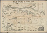
Bird's eye view of Kioto and surrounding country / Y. Shimidzu

Descriptions of some of the new Marine Invertebrata from the Chinese and Japanese Seas (Communicat...

Pilgrims' map of Mount Fuji and surrounding temples

Durville Island and Approaches

Plans of Anchorages in Witu Islands

Ryōtō Kaiwan : Daitzu Shan to Fuchou Chao

Japan, acreage of rice by prefectures, 1939. Japan, acreage of wheat by prefectures, 1939

Manshū Gomanbun no ichi Haisen Kokusan fukin
![[Palembang and Bangka Island, Indonesia] Het Eiland Banka. 1819 [and] De Rivier van Palembang. 1821](https://stacks.stanford.edu/image/iiif/vz793zp5933%2F36200/full/!200,200/0/default.jpg)
[Palembang and Bangka Island, Indonesia] Het Eiland Banka. 1819 [and] De Rivier van Palembang. 1821

Jūmanbunnoichi Guamutō fukin

Australia : Coral Sea and Great Barrier Reefs. Sheet 2

Rongorapputō fukin

Eastern Portion of Flores to Lomblem

Descripcion De Las Indias Del Poniente

Straits between Sumbawa, Flores and Sumba

Ryukyu Islands roads, railroads and cables
The island of Formosa

Yōzu (kūchū shashin sokuryō) Rusontō jūmanbun no ichi zu

Torokina Hikōjo

Jūmanbunnoichi Maroerapputō fukin

Carte des Isles du Japon et la Presqu Isle de Coree Avec les Costes de la Chine. Depuis Pekin Jusqu'a Canton...
![Nijūmanbunnoichi zu Sau shotō [cartographic material]](https://stacks.stanford.edu/image/iiif/kv237jg1154%2Fkv237jg1154_00_0001/full/!200,200/0/default.jpg)
Nijūmanbunnoichi zu Sau shotō [cartographic material]
森林鉄道布設図

Proposed plan of Ujigawa denki kabushiki kwai-sha : From Nango, Ishiyama-Mura, Shiga Prefecture, t...

Plans on the West Coast of Celebes

Guide to Tokyo City

China - east coast : Hangchow Wan - southeast portion : including the approaches to the Yung Kiang
Last Updated: 2020-06-05
Uploaded: 2021-07-22