Hokkaido, Japan : Special airfield relief map / prepared and reproduced in the United States Department of the Interior Geological Survey
- People
- Time
- Owner Organization
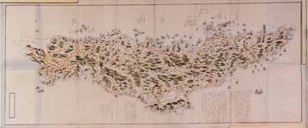
Relief map of Northern Honshu : special airfield relief map / prepared and reproduced in the United States Department of the Interior Geological Survey
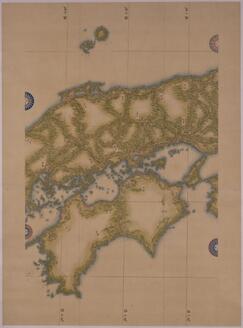
Relief map of Southern Japan : special airfield relief map / prepared and reproduced in the United States Department of the Interior Geological Survey
Hokkaido, Japan / prepared and reproduced in the United States Department of the Interior, Geological Survey
Relief map of Northern Honshu / prepared and reproduced in the United States Department of the Interior Geological Survey
Relief map of southern Japan / prepared and reproduced in the United States Department of the Interior Geological Survey
General map of China and adjacent regions, showing treaty ports and railways / prepared for the Department of State, by the Topographic Branch, U.S. Geological Survey

The M9.0 Great Tohoku Earthquake (northeast Honshu, Japan) of March 11, 2011 : earthquake summary map / U.S. Geological Survey

Target Tokyo. Newsmap. Prepared and Distributed by the Army Orientation Course. Special Service Di...
Caroline Islands 1:25,000 : Yap / prepared under the direction of Engineer, Hq AFFE/BA, by the Military Geology Branch, Intelligence Division ; map compiled by C. G. Johnson, geologist, Military Geology Branch, U.S. Geological Survey, for the Intelligence Division, Office of the Engineer, Hq. U.S. Army Japan
Special map : Haha Jima / prepared for CinCPac-CinCPOA by 64th Engr. Top. Bn. USAFCPBC, Dec. 1944 ; reproduced by 30th Engr. Base Top. Bn. USAFCPBC No. 1337-1, February 1945
Special map : Muko Jima / prepared for CinCPac-CinCPOA by 64th Engr. Top. Bn. USAFCPBC, No. 1157 Jan. 1945 ; reproduced by 30th Engr. Base Top. Bn. USAFCPBC No. 1340-1, February 1945
Japan 1:500,000 / prepared under the direction of the Engineer, U.S. Sixth Army by the 69th EngineerTopo. Co., July 1945 ; reproduced by BMP no 1, GHQ. AFPAC, U.S. Army
Hokkaido, Japan / prepared and reproduced in the United States Department of the Interior, Geological Survey

Gojūmanbun no ichi yochizu
![能登国[北陸道図]](https://rmda.kulib.kyoto-u.ac.jp/iiif/RB00020037/RB00020037_00001_0.ptif/full/200,/0/default.jpg)
能登国[北陸道図]

藤津郡七浦郷山浦邑

紀伊半嶋地図(仮称)
Map of Japan (Medium-Sized Map)
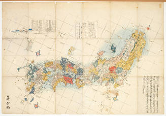
Map of the Japanese Archipelago
Sanyousaninzu

朝鮮總圖 = General map of Chosen (Korea)
![佐渡国[北陸道図]](https://rmda.kulib.kyoto-u.ac.jp/iiif/RB00020040/RB00020040_00001_0.ptif/full/200,/0/default.jpg)
佐渡国[北陸道図]

牧渓/柏猿猴図

Akashi, Hyogo-Ken, Honshu, Japan

探幽/竹ニ鶴梅ニ鶴図

小城郡村図上無津呂村
![淡路国[南海道図]](https://rmda.kulib.kyoto-u.ac.jp/iiif/RB00020058/RB00020058_00001_0.ptif/full/200,/0/default.jpg)
淡路国[南海道図]
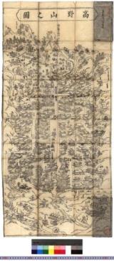
高野山之図 : 高野山大絵図

小城郡村図多久原村

Bankoku zenzu

Sekien gafu (Object)

Carte de l'empire du Japon, dressée sur les auteurs japonois, sur les mémoires des portugais et de...
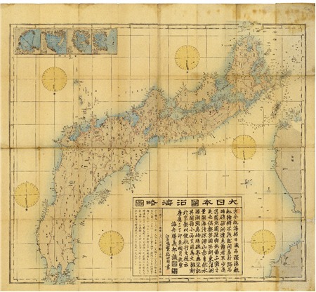
Dainihonenkairyakuzu
![[歴民カード_考古] 辻金具](https://khirin-i.rekihaku.ac.jp/iiif/nmjh_rekimin_a/22247141_02.tif/full/200,/0/default.jpg)
[歴民カード_考古] 辻金具
Map of Japan: Tōhoku Region
Last Updated: 2020-06-05
Uploaded: 2021-07-22