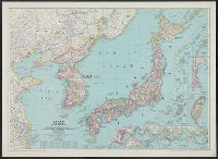
Japan and adjacent regions of Asia and the Pacific Ocean / compiled and drawn in the Cartographic Section of the National Geographic Society
- Time
- Owner Organization
![Japan and adjacent regions of Asia and the Pacific Ocean [cartographic material] / compiled and drawn in the...](https://collections.library.yale.edu/iiif/2/15510875/full/!200,200/0/default.jpg)
Japan and adjacent regions of Asia and the Pacific Ocean [cartographic material] / compiled and drawn in the...
![Japan and adjacent regions of Asia and the Pacific Ocean [cartographic material] / compiled and drawn in the...](https://collections.library.yale.edu/iiif/2/15509964/full/!200,200/0/default.jpg)
Japan and adjacent regions of Asia and the Pacific Ocean [cartographic material] / compiled and drawn in the...
Theater of war in the Pacific Ocean / compiled and drawn in the Cartographic Section of the National Geographic Society for the National Geographic Magazine

Japan and Korea / compiled and drawn in the Cartographic Section of the National Geographic Society ; James ...
Japan and Korea / compiled and drawn in the Cartographic Section of the National Geographic Society ; James ...
Pacific Ocean / compiled and drawn in the Cartographic Section of the National Geographic Society for the National geographic magazine ; Gilbert Grosvenor, editor ; Albert H. Bumstead, chief cartographer ; culture by James M. Darley ; physiography by Charles E. Riddiford
North Pacific Ocean / compiled & drawn by J.W. Appleton ; engraved by Homewood & Son
Japan and adjacent regions of Asia and Pacific Ocean, 1944. Report No. 37-a(32), USSBS Index Section 6

The world. compiled and drawn by the American Geographical Society for the Department of State ; lith. A. Hoen & Co., Inc

General map of China and adjacent regions, showing treaty ports and railways

Japan and it's relation to the territory bordering on the Pacific ocean

Japan and its relation to the territory bordering on the Pacific Ocean

Map of Japan and adjacenl regions. The Society for International Gulturel Relations. Tokyo 1937

General map of China and adjacent regions showing treaty ports and railroads / prepared for the Department o...
Atlas of isotope hydrology - Asia and the Pacific

Map of China And the Surrounding Regions. Compiled from the latest information by E. Bretscheider....

Charts, etc

Asia, Japan and Korea : with the surrounding seas and the adjacent coastal region of China / published at Wa...

Reported Dangers to navigation in the Pacific Ocean, inclusive of the China and Japan Seas and the...

Rand McNally map of Eastern Asia and Western Pacific Ocean. (Mercator projection). Copyright by Ra...
Rand McNally map of Eastern Asia and Western Pacific Ocean. Mercator projection. Copyright by Rand...

(Covers to) Rand McNally map of Eastern Asia and Western Pacific Ocean Mercator projection. Copyri...

A voyage of discovery to the North Pacific Ocean in which the coast of Asia, from the lat. of 35@ ...
A voyage of discovery to the North Pacific Ocean in which the coast of Asia, from the lat. of 35@ ...
Theater of war in the Pacific Ocean / compiled and drawn in the Cartographic Section of the National Geographic Society for the National Geographic Magazine
Dai Nippon Teikoku zenzu

Bartholomew's Special Map of China, Japan and Korea

Asiae Recentissima Delineatio Qua Status et Imperia Totius Orientis unacum Orientalibus Indiis…

「北白川瀧ノ景」「上加茂之社」「洛東華頂山知恩院細図」 「SHIRAKAWA」「KAMIGAMO ST」「CHIOIN BT」

Carte générale de la Tartarie Chinoise dressée sur les cartes particulières faites sur les lieux p...
「義経一代記之内(よしつねいちだいきのうち)」 「八回」「五條の社(やしろ)に牛若丸(うしわかまる)白河の湛海(たんかい)を討取(うちとる)」

「百人一首之内」 「源重之(「みなもとのしげゆき」)」「四十八」

Hermann Berghaus : Chart of the world on Mercators projection
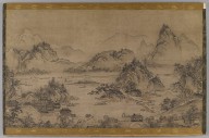
Landscape of West Lake
「江戸名所道戯尽」 「二十五」「亀戸太鼓はし」
![百人一首之内 清原元輔 ; [42]](https://adeac.jp/items/adeac-arch/catalog/001-mp001934-200010/t.jpg)
百人一首之内 清原元輔 ; [42]

Carte Des Indes et de la Chine Dressee sur plusieurs Relations particulieres Rectifees par quelque...

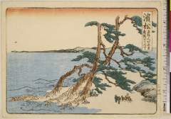
Fujikawa
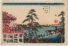
「東都名所」 「上野自清水堂(きよみずどうより)観不忍(しのばずをみる)図」
Imperii Sinarum nova descriptio [prepared by Martino Martini]

大佐賀最新市街全図
Hamamatsu、maisakahenirisanjitchou
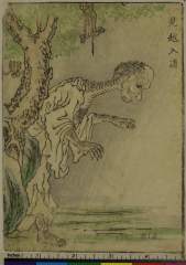
Mikoshinyuudou
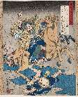
「盛衰記人品箋」 「佐々木四郎高綱」

Chasing measles away

Carte générale de la Tartarie Chinoise dressée sur les cartes particulières faites sur les lieux p...

Tabula Tartariae et majoris partis Regni Chinae . .
「(人物東海道)五十三次」 「水口(みなくち)」
Last Updated: 2020-06-05
Uploaded: 2021-07-22