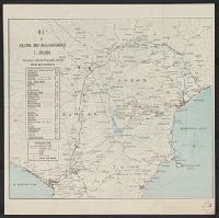
Portuguese Timor (Chimōrutō tōbu) topographical and geological map : Poryō Chimōru-tō
- People
- Time
- Owner Organization
![Imperial Geological Survey of Japan topographical map : Division I-[V]](https://collections.library.yale.edu/iiif/2/15828616/full/!200,200/0/default.jpg)
Imperial Geological Survey of Japan topographical map : Division I-[V]
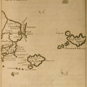
Map showing Pelew Island, immediately north of Dutch New Guinea, and Dili, in Portuguese Timor, between whic...

Topographical map of the Japanese Empire, 1899 / Imperial Geological Survey of Japan ; drawn by T. Togawa an...

A new and accurate map of the Empire of Japan. Laid down from the memoirs of the Portuguese and Du...

Geological map of the Japanese Empire on the scale of 1:1,000,000

A new and accurate map of the Empire of Japan : laid down from the memoirs of the Portuguese and Dutch, and ...
Relief map of Southern Japan : special airfield relief map / prepared and reproduced in the United States Department of the Interior Geological Survey
Relief map of Northern Honshu : special airfield relief map / prepared and reproduced in the United States Department of the Interior Geological Survey
Relief map of Northern Honshu / prepared and reproduced in the United States Department of the Interior Geological Survey
Relief map of southern Japan / prepared and reproduced in the United States Department of the Interior Geological Survey
Hokkaido, Japan : Special airfield relief map / prepared and reproduced in the United States Department of the Interior Geological Survey

Map of Tokyo and Yokohama
General map of China and adjacent regions, showing treaty ports and railways / prepared for the Department of State, by the Topographic Branch, U.S. Geological Survey

The M9.0 Great Tohoku Earthquake (northeast Honshu, Japan) of March 11, 2011 : earthquake summary map / U.S. Geological Survey
Portuguese Timor : showing native attitude / prepared by (G) Research from information supplied by Lt. P.P. McCabe as at 25/11/'42
Map and guide of Hakone and neighbourhood
Map of Laputa and Luggnag

American, French and Portuguese Soldiers Marching on a Parade Ground at Yokohama

Geological researches in China, Mongolia, and Japan during the years 1862 to 1865
Map of Kyoto and its Suburbs
Map of Edo and Its Environs

大日本帝國油田第九區地質及地形圖 : 越後國寺泊油田 = Geological and topographical map of the oil fields of Japan, section IX : Teradomari oil field, Echigo
New railway map of Tokyo and vicinity. Published by Japan Guide Map Co., Ltd. Compiled and printed...
Hokkaido, Japan / prepared and reproduced in the United States Department of the Interior, Geological Survey
Last Updated: 2020-06-05
Uploaded: 2021-07-22