Tsunamis in the Pacific Basin, 1900-1983 / map produced by Patricia A. Lockridge, National Geophysical Data Center and Ronald H. Smith, Cooperative Institute for Research in Environmental Sciences ; published by National Geophysical Data Center and World Data Center A for Solid Earth Geophysics with support from Office of U.S. Foreign Disaster Assistance, Agency for International Development in cooperation with Circum-Pacific Council for Energy and Mineral Resources, Map Project
- People
- Time
- Owner Organization
Theater of war in the Pacific Ocean / compiled and drawn in the Cartographic Section of the National Geographic Society for the National Geographic Magazine

A pictorial map : Victory in the Pacific Designed and published by Ernest Dudley Chase of Winchest...
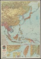
Pacific Ocean / compiled and drawn in the Cartographic Section of the National Geographic Society for the National geographic magazine ; Gilbert Grosvenor, editor ; Albert H. Bumstead, chief cartographer ; culture by James M. Darley ; physiography by Charles E. Riddiford
Span of the U.S. in the Pacific / news map by staff artist Sundberg

JAPANESE SHIPS DESTROYED BY BOMBERS IN PACIFIC AND INDIAN OCEANS

map from "Canadian Pacific Railway's Royal Mail Steamship Line. Japan and China ... Handbook of in...

map from "Canadian Pacific Railway's Royal Mail Steamship Line. Japan and China ... Handbook of in...

Japan and the United States. Seminars sponsored by Center for East Asian Studies & others

Japan and the United States. Seminars sponsored by Center for East Asian Studies & others

CDNLAO newsletter : forum for the Conference of Directors of National Libraries in Asia and Oceania
War map III featuring the Pacific Theater
![Japan and adjacent Asiatic mainland [cartographic material]](https://collections.library.yale.edu/iiif/2/15511788/full/!200,200/0/default.jpg)
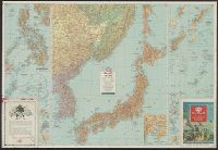
Japan and adjacent Asiatic mainland [cartographic material]
Esso war map III featuring the Pacific Theater : a third war map / edited, drafted and printed by the makers...
Esso war map III featuring the Pacific Theater : a third war map / edited, drafted and printed by the makers...
![The Pacific Theater [cartographic material]](https://collections.library.yale.edu/iiif/2/15472146/full/!200,200/0/default.jpg)
The Pacific Theater [cartographic material]
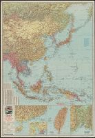
Japan and adjacent regions of Asia and the Pacific Ocean / compiled and drawn in the Cartographic Section of the National Geographic Society

ALLIED BATTLESHIPS AND CARRIERS MASS IN PACIFIC AND INDIAN OCEANS FOR WAR AGAINST JAPAN

Map of Asia

Geographical and Statistical Map of China. China and the Tributary Kingdom of Corea. For the Eluci...

map from "Niphon and Pe-che-li; or, Two years in Japan and Northern China. [With plates and a map....
Pacific war map / Dept. of Home Security ; issued by authority of the Minister for Home Security with the permission of Associated Newspapers Ltd
Court Exh. No. 2657: Map made by the USSR and published in 1935. For idetification only

Strategical map of part of Korea and Manchuria / prepared by the Second Division, General Staff (Military In...
.jpg)
This map indicates the tactical position in the Pacific in August 1942 when the Allied counter offensive was...
Last Updated: 2020-06-05
Uploaded: 2021-07-22