General map of China and adjacent regions, showing treaty ports and railways / prepared for the Department of State, by the Topographic Branch, U.S. Geological Survey
- Time
- Owner Organization

General map of China and adjacent regions, showing treaty ports and railways

General map of China and adjacent regions showing treaty ports and railroads / prepared for the Department o...
Hokkaido, Japan / prepared and reproduced in the United States Department of the Interior, Geological Survey
Japan and adjacent regions / prepared and distributed by Army Information Branch, Army Service Forces
Relief map of Northern Honshu / prepared and reproduced in the United States Department of the Interior Geological Survey
Relief map of southern Japan / prepared and reproduced in the United States Department of the Interior Geological Survey
Hokkaido, Japan : Special airfield relief map / prepared and reproduced in the United States Department of the Interior Geological Survey
Relief map of Southern Japan : special airfield relief map / prepared and reproduced in the United States Department of the Interior Geological Survey
![Japan and adjacent regions of Asia and the Pacific Ocean [cartographic material] / compiled and drawn in the...](https://collections.library.yale.edu/iiif/2/15510875/full/!200,200/0/default.jpg)
Japan and adjacent regions of Asia and the Pacific Ocean [cartographic material] / compiled and drawn in the...
![Japan and adjacent regions of Asia and the Pacific Ocean [cartographic material] / compiled and drawn in the...](https://collections.library.yale.edu/iiif/2/15509964/full/!200,200/0/default.jpg)
Japan and adjacent regions of Asia and the Pacific Ocean [cartographic material] / compiled and drawn in the...
Relief map of Northern Honshu : special airfield relief map / prepared and reproduced in the United States Department of the Interior Geological Survey
Japan and adjacent regions of Asia and the Pacific Ocean / compiled and drawn in the Cartographic Section of the National Geographic Society

The M9.0 Great Tohoku Earthquake (northeast Honshu, Japan) of March 11, 2011 : earthquake summary map / U.S. Geological Survey

A Map of the East-Indies and the Adjacent Countries; with the Settlements, Factories and Territori...

A Map of the East-Indies and the Adjacent Countries; with the Settlements, Factories and Territori...

A Map of the East-Indies and the Adjacent Countries; with the Settlements, Factories and Territori...

A Map of the East-Indies and the Adjacent Countries; with the Settlements, Factories and Territori...

A Map of the East-Indies and the Adjacent Countries; with the Settlements, Factories and Territori...

A Map of the East-Indies and the Adjacent Countries; with the Settlements, Factories and Territori...

Japan and Korea. (with) The Japanese Empire. (with) Port Arthur and Adjacent Territory. (with) For...
Stanford's map of the empires of China and Japan : with the adjacent parts of the Russian Empire, ...
Caroline Islands 1:25,000 : Yap / prepared under the direction of Engineer, Hq AFFE/BA, by the Military Geology Branch, Intelligence Division ; map compiled by C. G. Johnson, geologist, Military Geology Branch, U.S. Geological Survey, for the Intelligence Division, Office of the Engineer, Hq. U.S. Army Japan

Series (Standard map series designation system) ; 5205

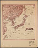
Map of Japan and adjacenl regions. The Society for International Gulturel Relations. Tokyo 1937
Last Updated: 2020-06-05
Uploaded: 2021-07-22