
Plan of Hong Kong City of Victoria . . .
- People
- Time
- Owner Organization
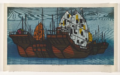
Boats of Hong Kong
Hong Kong
Hong Kong
City plan of Yokohama

City plan of Kōbe.
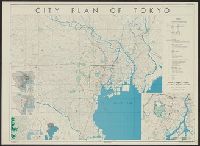
City plan of Tōkyō
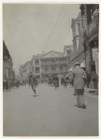
Hong Kong Chinese quarter

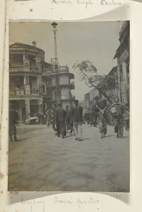
Chinese Temple, Hong Kong

Chinese Woman, Hong Kong

View of Hong-Kong From East Point
"Publieke tuin te Hong Kong"

At Mr. Boerner's Hong Kong

View of the USS KENTUCKY in Hong Kong Harbour
Photo No. 12: Dec. 19. Victoria Fortress. Hong Kong Bombing

Britain strengthens Hong Kong defences

Tokyo city plan
"Woning van den gouverneur te Hong Kong"
An aerial vieiv of Hong Kong, Britain's outpost in the China seas, ivhere the formal surrender of (.he city ...
"Commissie van het Hospitaal te Hong Kong"
Tokyo city plan : Marunouchi

Pandanu tree and Japanese girls -- Hong Kong, China

China, Japan, and Mongolia. (inset) Hong Kong and Vicinity
"Chinesche mandarijnen familie. Hong Kong 8 -10 sept 1873"

Chinese Empire (including Trans Oceanic Cables to Hong Kong,etc.)
![[Carte abrégée de la ville d'Osaka, divisée en quartiers.]](https://api.europeana.eu/api/v2/thumbnail-by-url.json?uri=http%3A%2F%2Fgallica.bnf.fr%2Fark%3A%2F12148%2Fbtv1b530667803.thumbnail.jpg&type=IMAGE)
[Carte abrégée de la ville d'Osaka, divisée en quartiers.]
Dai ichi-gun no heitan : Meiji sanjūnana-nen hachi-gatsu nijūgo nichi

A New & Accurate Chart of the Discoveries made by the late Capt. Js. Cook, and other distinguished...

Descripcion De Las Indias Del Poniente

Carte des isles du Japon et la presqu'isle de Corée avec les costes de la Chine depuis Pekin jusqu...

「権中納言定家(墨絵)」
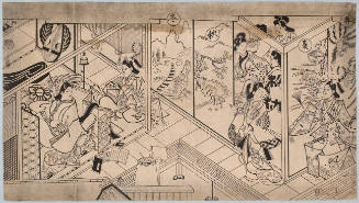
The Four Seasons, Modern Reproduction
![Bakyōshi fukin chikeizu [cartographic material]](https://stacks.stanford.edu/image/iiif/kh185vk2388%2Fkh185vk2388_00_0001/full/!200,200/0/default.jpg)
Bakyōshi fukin chikeizu [cartographic material]

「勧進能興行場所全図(弘化五年筋違橋御門外)」

Carte des Isles du Japon et la Presqu Isle de Coree Avec les Costes de la Chine. Depuis Pekin Jusqu'a Canton...

Nyūjōjiatō fukin sozu
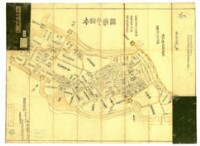
永田甼繪圖 : 全

Empire of Japan. (with) Nagasaki Harbour. Engraved by J. & C. Walker. Published under the superint...
![Tokyo city proper [cartographic material]](https://stacks.stanford.edu/image/iiif/vj067cj0650%2Fvj067cj0650_00_0001/full/!200,200/0/default.jpg)
Tokyo city proper [cartographic material]

Kita Karafuto niman-gosenbun no ichizu
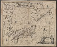
Nova et Accurata Japoniae, Terrae Esonis, ac Insularem Adjacentium ex Novissimâ detectione descriptio

The Guide Map to the Railway in The Neighbourhood of Tokyo

Plata Americae Provincia
The island of Formosa
![Yokkaichi kōkū shashin sokuryōzu [cartographic material]](https://stacks.stanford.edu/image/iiif/dx686xz3690%2Fdx686xz3690_00_0001/full/!200,200/0/default.jpg)
Yokkaichi kōkū shashin sokuryōzu [cartographic material]
A new & correct chart of the Indian Sea from Cabo Bonea Esperanca to Japan according to Mr. Edward Wrights projection vulgarly called Mercators chart

Chart Prepared By James B. Moore, To Accompany His Memorial To Congress Respecting the subject of ...
Dai ni-gun no heitan : Meiji sanjūnana-nen hachi-gatsu jūichi nichi

Carte du Japon
Last Updated: 2020-04-17
Uploaded: 2021-09-21