An aerial vieiv of Hong Kong, Britain's outpost in the China seas, ivhere the formal surrender of (.he city ...
- Time
- Owner Organization

Plan of Hong Kong City of Victoria . . .
Stanford University Libraries
Stanford Libraries SearchWorks

View of the USS KENTUCKY in Hong Kong Harbour
Australian National Maritime Museum
Trove: National Library of Australia
Ah aerial view of Manila, which has been heavily bombed by Japanese aircraft. The old Spanish walled city is...
National Library of New Zealand
DigitalNZ New Zealand API
An aerial view of Dutch Harbour, in the Aleutian Islands, site of Ajnerica's important naval and air base so...
National Library of New Zealand
DigitalNZ New Zealand API
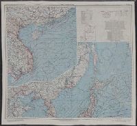
AAF cloth chart ; no. C-52, C-53
Yale University Library
Yale University Library Digital Collections
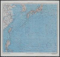
Japan and South China Seas / prepared at the direction of the commanding general, Army Air Forces, for the A...
Yale University Library
Yale University Library Digital Collections
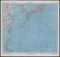
Japan and South China Seas / prepared at the direction of the commanding general, Army Air Forces, for the A...
Yale University Library
Yale University Library Digital Collections
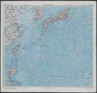
East China Sea
Yale University Library
Yale University Library Digital Collections

East China Sea
Yale University Library
Yale University Library Digital Collections
Midway Island, a lonely United Stales outpost, 1300 miles north-west of Hawaii, attacked on Thursday by airc...
National Library of New Zealand
DigitalNZ New Zealand API
Aerial view of the cross-roads to Castelfrentano and Guardiagrele in the Sangro River area, Italy, World War...
Alexander Turnbull Library
DigitalNZ New Zealand API
Aerial view of the Sangro River looking towards the NZ Division area, Italy, World War II - Photograph taken...
Alexander Turnbull Library
DigitalNZ New Zealand API
Aerial view of 2 NZ Division HQ and surrounding countryside in the Sangro River area, Italy, World War II - ...
Alexander Turnbull Library
DigitalNZ New Zealand API
Aerial view of a mountain village in the Sangro River area, Italy, World War II - Photograph taken by George...
Alexander Turnbull Library
DigitalNZ New Zealand API
Battle-scarred Namur.—Wounds of the great air and naval bombardment of the former Japanese base in the Centr...
National Library of New Zealand
DigitalNZ New Zealand API
The Oriental navigator, or, Directions for sailing to, from, and upon the coasts of, the East-Indies, China, Australia...To the work are prefixed a series of ... tables of the determined positions of all the principle points and places from the British seas to Cape Horn, the Cape of Good Hope, and thence to the islands of Japan, by John Purdy. (Plan of Chatham Island, &c. Whittle & Laurie, London, 1815.)
National Library of Australia
Trove: National Library of Australia
Last Updated:
Uploaded: 2020-12-17