
A Chart of the Eastermost part of the East Indies and China from Cape Comarin to Japan with the Ad...
- People
- Time
- Owner Organization

A Chart of the Eastermost part of the East Indies and China from Cape Comarin to Japan with the Ad...
A chart of ye eastermost part of the East Indies / by Iohn Seller

A chart of the easternmost part of the East Indies with all the adjacent islands from Cape Comorin...
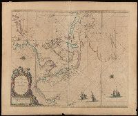
A chart of the eastermost part of the East Indies with all the adjacent islands from Cape Comorin to Iapan / by Iohn Seller, Hydrographer to the King

A chart of the eastermost part of the East Indies with all the adjacent islands from Cape Comorin to Iapan / by Iohn Seller, Hydrographer to the King ; F. Lamb Sculp

A chart of the tradeing part of the East Indies and China, with the adjacent islands, from Surrat ...

Chart of the Coast of China from Cambodia to Nanquam with Part of Japan
A chart of the northern part of the China Sea shewing the passage from Formosa to Japan : with the eastern coast of China and the Lekeyo Islands

A Chart of the Coast of China From Cambodia to Nanquam with Part of Japan

Chart of the coast of China and of the Japan islands including the Marianes and part of the Philippines

A Map of the East-Indies and the Adjacent Countries; with the Settlements, Factories and Territori...

A Map of the East-Indies and the Adjacent Countries; with the Settlements, Factories and Territori...

A Map of the East-Indies and the Adjacent Countries; with the Settlements, Factories and Territori...

A Map of the East-Indies and the Adjacent Countries; with the Settlements, Factories and Territori...

A Map of the East-Indies and the Adjacent Countries; with the Settlements, Factories and Territori...

A Map of the East-Indies and the Adjacent Countries; with the Settlements, Factories and Territori...
![East India Archipelago [Eastern Passages to China and Japan] [Chart No. 4] . . . 1868 (Mindanao, B...](https://stacks.stanford.edu/image/iiif/qk341np8650%2F34532/full/!200,200/0/default.jpg)
East India Archipelago [Eastern Passages to China and Japan] [Chart No. 4] . . . 1868 (Mindanao, B...
Portrait of Jacques Specx, Governor-General of the Dutch East Indies
![East India Archipelago [Eastern Passages to China and Japan] [Chart No. 2] . . . 1868 (North Austr...](https://stacks.stanford.edu/image/iiif/hf333br4460%2F34582/full/!200,200/0/default.jpg)
East India Archipelago [Eastern Passages to China and Japan] [Chart No. 2] . . . 1868 (North Austr...
The invasion of the Dutch East Indies
![East India Archipelago [Eastern Passages to China and Japan] [Chart No. 7] . . . 1868 (Taiwan, Nor...](https://stacks.stanford.edu/image/iiif/xy078vp9272%2F34545/full/!200,200/0/default.jpg)
East India Archipelago [Eastern Passages to China and Japan] [Chart No. 7] . . . 1868 (Taiwan, Nor...
![East India Archipelago [Eastern Passages to China and Japan] [Chart No. 1] . . . 1866 (Java, Borne...](https://stacks.stanford.edu/image/iiif/ww842xr3210%2F34640/full/!200,200/0/default.jpg)
East India Archipelago [Eastern Passages to China and Japan] [Chart No. 1] . . . 1866 (Java, Borne...
A chart of the northern part of the China Sea shewing the passage from Formosa to Japan with the eastern coast of China and the Lekeyo islands / by Van Kuelen ; improved from the maps drawn in China by Father Gaubil in 1752
A Chart of the Northern Part of the China Sea [Material cartográfico] : shewing the Passage from F...
A Chart of the Eastermost part of the East Indies and China from Cape Comarin to Japan with the Ad...

Karte von Australien oder Polynesien, nach den Zeichnungen, Reisebe Schreibungen und Tagebucher de...

A New and Correct Chart of all the Known World Laid down according to Mercator's Projection

(Composite Map of) Map of the Island of Japan, Kurile &c. with the Adjacent Coasts of the Chinese ...
Paskaerte zynde t'Oosterdeel van Oost Indien : met alle de Eylanden daer ontrendt geleegen van C. Comorin to...
Pictures after Nature

A New and Correct Chart of all the Known World Laid down according to Mercator's Projection

L'Empire de la Chine avec les isles du Japon. A Paris, ches Lattre, rue St. Jacq. (ca. 1800)
A new map of the empires, states, provinces &c of Asia : including also the Turkish & Russian dominions in Europe & New Holland / compiled from the most authentic observations by Robert Wilkinson ; Walsh script. ; W. Palmer sculpt
A new & accurate map of Asia : drawn from the most approved modern maps & charts / by Thos. Bowen ; engraved for Middletons complete system of geography

Mappemonde ou Carte Reduite Des Parties Connues Du Globe Pour servir au Voyage de La Perouse …. 17...

Tabula Geodoborica Itinerum a Varijs in Cataium susceptorum rationem exhibens (Kircher's map of hi...

東亜現勢地図

「諸軍談」

北支事変方面概見図

Empire of Japan. (with) Nagasaki Harbour. Engraved by J. & C. Walker. Published under the superint...

To the Right Honorable William Lord Cowper Lord High Chancellor of Great Britain This Map of Asia ...

Paskaerte Zynde t'Oosterdeel Van Oost Indien, met alle de Eylanden daer ontrendt geleegen van C.Co...
Japanese Empire--802 M

The Empire of Japan Divided into Seven Principal Parts and Subdivided ino Sixty Six Kingdoms; with...

Carte Des Indes et de la Chine Dressee sur plusieurs Relations particulieres Rectifees par quelque...
Empire of Japan / published under the superintendence of the Society for the Diffusion of Useful Knowledge

Karta Morskykh Otkrytii Rossiiskimi Moreplavatelimi na Tikhom ... [transliterated from the Cyrilli...

Karte von Australien oder Polynesien, nach den Zeichnungen, Reisebe Schreibungen und Tagebucher de...
Last Updated: 2020-04-17
Uploaded: 2021-09-21