
A Map of the Middle British Colonies In North America First Published By Mr. Lewis Evans of Philad...
- People
- Time
- Owner Organization

An accurate Map of the British Colonies in North Ameria bordering on the River Ohio (First Appeara...

A New Map of North America, with the British, French, Spanish, Dutch & Danish Dominions on that gr...

Map of the State of New York Published by Charles Magnus

Map of the State of New York Published by Charles Magnus

Map of the State of New York Published by Charles Magnus

Map of the State of New York Published by Charles Magnus

The Kingfisher first animal picture atlas / written by Deborah Chancellor ; illustrated by Anthony Lewis

A New and Accurate Map of the Colony of Massachusets Bay, In North America from a Late Survey

A New and Accurate Map of the Colony of Massachusets Bay, In North America from a Late Survey

New map of Shanghai. (on verso) A map of China : Published by K. Saito. Osaka Japan Sole agent T. ...

The New War Map of Maryland Part of Virginia & Pennsylvania. Published by B.B. Russell . .
New railway map of Tokyo and vicinity. Published by Japan Guide Map Co., Ltd. Compiled and printed...

Map of Japan. Published by George F. Cram, Chicago, Ill. (to accompany) Cram's atlas of the world,...
Picture map of China. Designed by Frank Randolph Southard. Printed in United States of America. (C...

Picture map of China. Designed by Frank Randolph Southard. Printed in United States of America. (C...

A pictorial map : Victory in the Pacific Designed and published by Ernest Dudley Chase of Winchest...

Cambridge Chrysanthemum Show - Mr. P. McDermott's First Prize Exhibit of 36 Japanese blooms
British Official Photo—VlA BEAM WIRELESS. First picture of Britain's newest aircraft-carrier, the Indefatiga...

A map of China : Published by K. Saito. Osaka Japan. Sole agent T. Kishida & Co. Shanghai. (inset ...
Map of North Africa showing the extent of operations undertaken by the Long Range Desert Group during World ...
A map of China : Published by K. Saito. Osaka Japan. Sole agent T. Kishida & Co Shanghai. (inset m...
Mr. K. Dcbuchi, the -first president of the Japanese New Zealand Society recently formed in Tokio. Mr. Dcbuc...

Japan, the target : a pictorial Jap-map : By Ernest Dudley Chase of Winchester, Mass. Published an...
Craigie's map of South Australia showing towns, roads & railways / compiled, drawn & published by Kenneth Craigie & Co

Carte Des Indes et de la Chine Dressee sur plusieurs Relations particulieres Rectifees par quelque...

Christianographie (Ancient World)

Asia
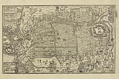
「大阪案内独巡」

「「ウガンダ」酋長及ヒ土人ノ図」

「江戸神田明神社内風景」 「呼名 神田社」

Erie Railway and connections. (inset) Map of New York City & vicinity issued by N.Y.L.E. & W. R.R....

Descriptio Hydrographica accomodata ad Battavorum navagatione Javam Insula Indiae Orientalis . . ....

La Gran Tartaria divisa nelle sue parti prinicpali . . . conforme le relazioni, che s' hanno da gl...
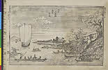
「江戸三囲堤花見景色」 「呼名 みめぐり」

「祇園石段 西楼門之景」

(上陸)

「大仏耳塚」

「江戸亀井戸天満宮」 「呼名 亀井戸」

「華頂山桜馬場風景」

「大仏耳塚」

「江戸芝三縁山増上寺」 「呼名 増上寺」

「安芸厳島神社之図」

「江戸隅田川月見景」 「呼名 月ノ隅田川」

Plan de Nagasaki / par Tomijimaya

Carte Des Indes et de la Chine Dressee sur plusieurs Rectifees par quelques Observations Par Guill...

Carte Des Indes Orientales dessinee suivant les Observations les plus recentes dont le principal e...
![Kome no seisan narabi ryūdō ryakuzu [cartographic material]](https://stacks.stanford.edu/image/iiif/wk302kq9237%2Fwk302kq9237_00_0001/full/!200,200/0/default.jpg)
Kome no seisan narabi ryūdō ryakuzu [cartographic material]
Manshūkoku chizu / Minami Manshū Tetsudō Kabushiki Kaisha chosaku ken hakkō
Last Updated: 2020-04-17
Uploaded: 2021-09-21