
Japan, Manchuria, and adjacent regions
- Time
- Owner Organization
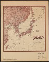
Japan and adjacent regions / prepared and distributed by Army Information Branch, Army Service Forces
![Japan and adjacent regions of Asia and the Pacific Ocean [cartographic material] / compiled and drawn in the...](https://collections.library.yale.edu/iiif/2/15510875/full/!200,200/0/default.jpg)
Japan and adjacent regions of Asia and the Pacific Ocean [cartographic material] / compiled and drawn in the...
![Japan and adjacent regions of Asia and the Pacific Ocean [cartographic material] / compiled and drawn in the...](https://collections.library.yale.edu/iiif/2/15509964/full/!200,200/0/default.jpg)
Japan and adjacent regions of Asia and the Pacific Ocean [cartographic material] / compiled and drawn in the...

General map of China and adjacent regions, showing treaty ports and railways

Japan and South Manchuria : Railway and steamer connections
Japan and adjacent regions of Asia and the Pacific Ocean / compiled and drawn in the Cartographic Section of the National Geographic Society

Japan and Korea. (with) The Japanese Empire. (with) Port Arthur and Adjacent Territory. (with) For...

Map of Japan and adjacenl regions. The Society for International Gulturel Relations. Tokyo 1937

General map of China and adjacent regions showing treaty ports and railroads / prepared for the Department o...

Travels of a naturalist in Japan and Manchuria
Travels of a naturalist in Japan and Manchuria
Travels of a naturalist in Japan and Manchuria

Map of Manchuria, Corea & Japan

Manchuria. Korea. Japan. (insets) (Vicinity of Osaka and Tokyo)
Stanford's map of the empires of China and Japan : with the adjacent parts of the Russian Empire, ...
![Map of Manchuria, Corea & Japan [cartographic material]](https://collections.library.yale.edu/iiif/2/15828540/full/!200,200/0/default.jpg)
Map of Manchuria, Corea & Japan [cartographic material]

portrait from "Travels of a Naturalist in Japan and Manchuria"

Eastern Asia, showing Japan, Korea, Manchuria and adjoining parts of Siberia and China. 185 miles ...

Charts, etc

Asia, Japan and Korea : with the surrounding seas and the adjacent coastal region of China / published at Wa...
![[Railroads in China, Manchuria, Korea, Japan and the eastern U.S.S.R.] [cartographic material]](https://stacks.stanford.edu/image/iiif/pf710vm7134%2Fpf710vm7134_00_0001/full/!200,200/0/default.jpg)
[Railroads in China, Manchuria, Korea, Japan and the eastern U.S.S.R.] [cartographic material]
Japan and adjacent regions of Asia and Pacific Ocean, 1944. Report No. 37-a(32), USSBS Index Section 6

The Japanese empire : with central and southern Manchukuo (Manchuria)

The Japanese empire : with central and southern Manchukuo (Manchuria)
![Orientation, Philippines to Japan [cartographic material]](https://stacks.stanford.edu/image/iiif/nh916xd2027%2Fnh916xd2027_00_0001/full/!200,200/0/default.jpg)
Orientation, Philippines to Japan [cartographic material]

Togian Isles to Peleng Strait

Campbell's Fahrt von Sannack nach Kodiak und Lage jener Inseln . . . 1817

New Guinea - South Coast. Freshwater Bay to C. Blackwood
![Gomanbunnoichi Kitashina kūchū shashin sokuryō yōzu [cartographic material]](https://stacks.stanford.edu/image/iiif/vq208jt9601%2Fvq208jt9601_00_0001/full/!200,200/0/default.jpg)
Gomanbunnoichi Kitashina kūchū shashin sokuryō yōzu [cartographic material]

Approach to West Coast of Gazelle Peninsula

Peleng Strait to Tomori Gulf

Rongorapputō fukin
![Hailaerh fukin zu [cartographic material]](https://stacks.stanford.edu/image/iiif/nc103dh1915%2Fnc103dh1915_00_0001/full/!200,200/0/default.jpg)
Hailaerh fukin zu [cartographic material]

Western Portions of Flores

Carta General Para Las Navegaciones a la India Oriental Por El Mar Del Sur Y el grande Oceano que ...
Carta General Para Las Navegaciones a la India Oriental Por El Mar Del Sur Y el grande Oceano que ...

Japan, political divisions

Japan : political divisions / Board of Economic Warfare ; drawn in R and A, OSS

Central Portion of Sumbawa with Pulo Tenga Islands
[Railroads in China, Manchuria, Korea, Japan and the eastern U.S.S.R.] [cartographic material]

Ryukyu Islands roads, railroads and cables

Eastern Portion of Flores to Lomblem

Japan. Re- Published, Jany st. 1845, by G.F. Cruchley, Mapseller, 81 Fleet Street, London. (to acc...
![[Russian Map of Northeastern Asia, Japan, Korea, China, Alaska, etc.] ( Summary map of hydrographi...](https://stacks.stanford.edu/image/iiif/pj697kr2558%2F35405/full/!200,200/0/default.jpg)
[Russian Map of Northeastern Asia, Japan, Korea, China, Alaska, etc.] ( Summary map of hydrographi...

Plans of Anchorages in Tomori Gulf and Adjacent Coast
![Kasei Kita Shina jūmanbun no ichi zu. Hsüchow (Xuzhou) [cartographic material]](https://stacks.stanford.edu/image/iiif/js550gn2130%2Fjs550gn2130_00_0001/full/!200,200/0/default.jpg)
Kasei Kita Shina jūmanbun no ichi zu. Hsüchow (Xuzhou) [cartographic material]

Carta General para las Navegaciones a la India Oriental por el Mar del Sur y el Grande Oceano que ...

Celebes - West Coast : Cape William to Tandyung Karang
Last Updated: 2020-04-17
Uploaded: 2021-09-21