


![[歴民カード_考古] 土師器 壷形土器](https://khirin-i.rekihaku.ac.jp/iiif/nmjh_rekimin_a/23348056_02.tif/full/200,/0/default.jpg)
[歴民カード_考古] 土師器 壷形土器

Japan distribution of waterworks

Mare Del Sud Detto Altrimente Mare Pacifico
陸奥(完成図)横12.3.9〔横断図面〕

奥御右筆衆御役屋敷絵図

假製北支那十万分一圖. 許州

Map of Tōkyō : city communications / printed by the Tokyo Printing Co., Ltd
![[清図]「大野絵図」(文化十二~十四年)・文政十二年改](https://adeac.jp/items/imizu-shinminato-mus/catalog/mp105020-15100/3-1-BIV101v2.jpg)
[清図]「大野絵図」(文化十二~十四年)・文政十二年改

Mare Del Sud Detto Altrimente Mare Pacifico

山領村ノ内字四本松全図
Plano de las bahías de Hiogo y Kobé. H. 793 [Material cartográfico]

奥御右筆衆御役屋敷絵図

五万分一地形圖 開聞嶽.
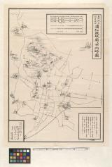
東照神君開運城跡浜松鉄城閣及市街略図

高家東御役屋敷絵図

Plan de Yokohama / par Sadahidé Hashimoto Gyokuransaï

元内藤豊後守御役宅 奥居間台所部屋共屋根取絵図

Carte générale d'une partie d'Afrique et d'Asie depuis le détroit de Gibraltar jusqu'aux isles du ...
![[Spanish Chart of the Philippines, China, Japan, Korea, Kamtchatka, Western Pacific]](https://stacks.stanford.edu/image/iiif/nk348cb2252%2F42187sh/full/!200,200/0/default.jpg)
[Spanish Chart of the Philippines, China, Japan, Korea, Kamtchatka, Western Pacific]

A New and Accurate Map of the World. Drawn from the best Surveys and regulated by Astronomical Obs...
Index to Admiralty charts of Nakai or Inland Sea, Korea Strait, Okhotsk Sea, Kamchatka and Peter the Great Bay / Hydrographic Office

Japan cities and towns : (shi and machi)
〔米軍艦シルエット図〕

浜松市全図
最終更新日: 2020-04-17
登録日: 2021-09-21