
Revised estimate of Nansei-Shotō (including Ryūkyū-rettō and Satsunan-shotō)
- Time
- Owner Organization
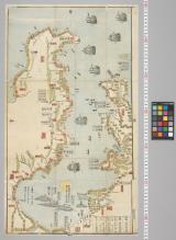
![Japan, Philippine Sea, Nansei Shotō (Ryuku [sic] Islands), including Daitō Shotō [electronic resou...](https://www.gumtree.com/static/1/resources/assets/rwd/images/orphans/a37b37d99e7cef805f354d47.noimage_thumbnail.png)
Japan, Philippine Sea, Nansei Shotō (Ryuku [sic] Islands), including Daitō Shotō [electronic resou...
Stanford University Libraries
Stanford Libraries SearchWorks
Japan, East coast of Honshū, including Nampō-Shotō [electronic resource]
Stanford University Libraries
Stanford Libraries SearchWorks

Figures and descriptions of the fishes of Japan : including Riukiu Islands, Bonin Islands, Formosa...
スミソニアン図書館
Europeana API
Figures and descriptions of the fishes of Japan : including Riukiu Islands, Bonin Islands, Formosa...
スミソニアン図書館
Europeana API

China, Contains 15 Subject Provinces, including the 2 Islands of Hainan Formosa and the Tributary ...
Stanford University Libraries
Stanford Libraries SearchWorks

China, Contains 15 Subject Provinces, including the 2 Islands of Hainan Formosa and the Tributary ...
Stanford University Libraries
Stanford Libraries SearchWorks

China, Contains 15 Subject Provinces, including the 2 Islands of Hainan Formosa and the Tributary ...
Stanford University Libraries
Stanford Libraries SearchWorks

China, Contains 15 Subject Provinces, including the 2 Islands of Hainan Formosa and the Tributary ...
Stanford University Libraries
Stanford Libraries SearchWorks
Writing Box with Decoration of Moon and Autumn Grasses, and with an assortment of writing implements including an ink stone, a metal water dropper, two covered brushes, and two covered knives (for correcting mistakes)
Harvard Art Museums
Harvard Art Museums API
Chart of the coast of China and of the Japan Islands including the Marianes and a part of the Philippines / compiled by order of Commodore M.C. Perry U.S.N. from the latest authorities with additions and corrections by the U.S. Japan Expedition by Lieuts. W.L. Maury and S. Bent U.S.N. ; drawn by Edw. Sels ; engr. by S. Siebert
National Library of Australia
Trove: National Library of Australia

禁裏
Kyoto University Library
IIIF Discovery in Japan

玉野市住居表示案内図
Tamano City Library
ADEAC: A System of Digitalization and Exhibition for Archive Collections
海岸守備図
Funabashi-shi Western Library
ADEAC: A System of Digitalization and Exhibition for Archive Collections
![Japan [cartographic material] : ports of greatest shipping activity](https://stacks.stanford.edu/image/iiif/yg817zs3009%2Fyg817zs3009_00_0001/full/!200,200/0/default.jpg)
Japan [cartographic material] : ports of greatest shipping activity
Stanford University Libraries
Stanford Libraries SearchWorks

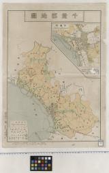
北海道地質鑛産圖
Yoshida-South Library, Kyoto University
IIIF Discovery in Japan
Japan--USSR : northern territories / Central Intelligence Agency
National Library of Australia
Trove: National Library of Australia
Dau Nihon Teikoku kōsanzu : Mineral distribution of Japanese empire
National Library of Australia
Trove: National Library of Australia

1745年、卞泰禧斜給立案
Kyoto University Library
IIIF Discovery in Japan

Jūmanbunnoichi Māsharu Shotō
Stanford University Libraries
Stanford Libraries SearchWorks

Japan : population densities by prefectures and provinces
Stanford University Libraries
Stanford Libraries SearchWorks

「臥龍園にて」
British Museum
ARC Ukiyo-e Portal Database

佐賀新市街地図
Saga Prefectual Library
IIIF Discovery in Japan
小石川谷中本郷繪圖
国際日本文化研究センター
SODA Collection: Pictorial and Miscellaneous Materials

飯笹村絵図(天保4)
多古町
ADEAC: A System of Digitalization and Exhibition for Archive Collections
柳都海岸略図
Funabashi-shi Western Library
ADEAC: A System of Digitalization and Exhibition for Archive Collections
千葉郡地図
Funabashi-shi Western Library
ADEAC: A System of Digitalization and Exhibition for Archive Collections
![備中国[山陽道図]](https://rmda.kulib.kyoto-u.ac.jp/iiif/RB00020052/RB00020052_00001_0.ptif/full/200,/0/default.jpg)
備中国[山陽道図]
Kyoto University Library
IIIF Discovery in Japan

大日本海陸全圖
Kyoto University Library
IIIF Discovery in Japan

Eastern Archipelago. Sumba or Sandelhout
Stanford University Libraries
Stanford Libraries SearchWorks
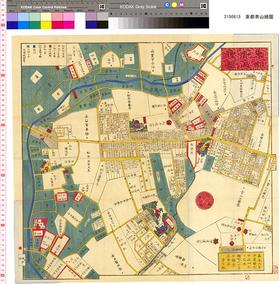
東都青山繪圖
国際日本文化研究センター
SODA Collection: Pictorial and Miscellaneous Materials

千葉県北総東葛飾郡沿浦之地図
Funabashi-shi Western Library
ADEAC: A System of Digitalization and Exhibition for Archive Collections
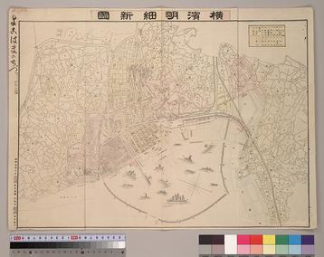
横濱明細新圖
国際日本文化研究センター
SODA Collection: Pictorial and Miscellaneous Materials

Southwest Japan (Kyūshū, Shikoku, and southwest Honshū), railroads and railroad facilities [cartog...
Stanford University Libraries
Stanford Libraries SearchWorks

1866년 김복동(金福東) 원납전단자(願納錢單子)
Kyoto University Library
IIIF Discovery in Japan
Last Updated: 2020-04-17
Uploaded: 2021-09-21