
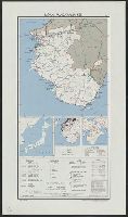
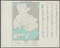
Izu, Bonin and Volcano Islands : Strategic location
- Time
- Owner Organization

Kanka Village, Bonin Islands
Philadelphia Museum of Art
Philadelphia Museum of Art collection

Figures and descriptions of the fishes of Japan : including Riukiu Islands, Bonin Islands, Formosa...
スミソニアン図書館
Europeana API
Figures and descriptions of the fishes of Japan : including Riukiu Islands, Bonin Islands, Formosa...
スミソニアン図書館
Europeana API

Japan. (with) Liu Kiu Is. (with) Bonin Islands, Ogasawara S. (with Tsubu Shoto) (with Nambu Shoto)...
Stanford University Libraries
Stanford Libraries SearchWorks
Kurile Islands special strategic map / compiled by the Army Map Service
National Library of Australia
Trove: National Library of Australia
Kurile Islands special strategic map (Sheet The geomagnetic vertical intensity (Z) in CGS-Unit for 1945 and areas of magnetic anomaly.)
National Library of Australia
Trove: National Library of Australia
Questionnaire No. 12. Volcano and Bonin Islands, 1 June 1944 to 15 August 1945. Pre-pared by: Major Shinami, Takejiro. Report No. 2-v(12), USSBS Index Section 8
NDL Digital Collections
NDL Digital Collections
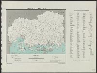
Strategic Japanese island Groups. compilation and drafting by 955th Engr. Topo. Co
National Library of Australia
Trove: National Library of Australia

Temporal and spatial evolution of the Izu Island Arc, Japan in terms of Sr-Nd-Pb isotope geochemis...
German National Library
Europeana API

Suruga, Kai, and Izu, no. 5 from the series "Cutout Pictures of the Provinces (Kunizukushi harimaze zue)"
Art Institute of Chicago
Art Institute of Chicago API

JAPANESE THREAT TO AUSTRALIA: ENEMY FORCES LAND AT RABAUL, IN NEW GUINEA AND THE SOLOMON ISLANDS
Auckland Libraries
DigitalNZ New Zealand API
WAR IN THE EAST This map shows Malaya and the Philippine Islands and the principal scenes of the Japanese of...
National Library of New Zealand
DigitalNZ New Zealand API
Okinawa henkan kinenzu : Map of Japan / limited first edition in commemoration of the return by the United States to Japan of Administrative Rights over the Ryūkyū Islands and the Daitō Islands, May 15, 1972
Library of Congress
Trove: National Library of Australia
Asia with its islands and different regions : according to their modern divisions ; also the discoveries made by Capt. Cook
National Library of Australia
Trove: National Library of Australia

The Actors Sanogawa Ichimatsu I as Oshichi and Nakamura Kumetaro I as Kichisaburo in the play "Izu Kosode Shobai Kagami," performed at the Nakamura Theater in the second month, 1751
Art Institute of Chicago
Art Institute of Chicago API

The Actors Arashi Sangoro II as Minamoto no Yoritomo (right), Segawa Kikunojo II as Yuki Onna (center), and Ichimura Uzaemon IX as Kajiwara Genta no Kagetoki, in the Play Myoto-giku Izu no Kisewata, Performed at the Ichimura Theater in the Eleventh Month, 1770
Art Institute of Chicago
Art Institute of Chicago API
The Oriental navigator, or, Directions for sailing to, from, and upon the coasts of, the East-Indies, China, Australia...To the work are prefixed a series of ... tables of the determined positions of all the principle points and places from the British seas to Cape Horn, the Cape of Good Hope, and thence to the islands of Japan, by John Purdy. (Plan of Chatham Island, &c. Whittle & Laurie, London, 1815.)
National Library of Australia
Trove: National Library of Australia
Japan--USSR : northern territories / Central Intelligence Agency
National Library of Australia
Trove: National Library of Australia
Okinawa, Japan, administrative divisions
National Library of Australia
Trove: National Library of Australia
![Japan [cartographic material] : ports of greatest shipping activity](https://stacks.stanford.edu/image/iiif/yg817zs3009%2Fyg817zs3009_00_0001/full/!200,200/0/default.jpg)
Japan [cartographic material] : ports of greatest shipping activity
Stanford University Libraries
Stanford Libraries SearchWorks

Japan, Oita-ken
Yale University Library
Yale University Library Digital Collections

Southwest Japan (Kyūshū, Shikoku, and southwest Honshū), telecommunications
Stanford University Libraries
Stanford Libraries SearchWorks
![[歴民カード_歴史] 封印判鑑帳](https://khirin-i.rekihaku.ac.jp/iiif/nmjh_rekimin_h/12747216_02.tif/full/200,/0/default.jpg)
[歴民カード_歴史] 封印判鑑帳
National Museum of Japanese History
IIIF Discovery in Japan
Japan, Wakayama-ken
Yale University Library
Yale University Library Digital Collections
![[De leus Asia Raja]](https://api.europeana.eu/api/v2/thumbnail-by-url.json?uri=http%3A%2F%2Fwww.beeldbankwo2.nl%2Fcgi-bin%2Ffrsiserver.dll%2Fthumbnail%2F191353-thumb.jpg%3Ffrskey%3D191353&type=IMAGE)
[De leus Asia Raja]
Museon
Europeana API

Les musiques bizarres à l'Exposition de 1900. La musique indo-chinoise : Chant annamite ; Danse ca...
Bibliothèque nationale de France
Europeana API
Northeast Asia
National Library of Australia
Trove: National Library of Australia
Ranyō Nyūginia zenzu
National Library of Australia
Trove: National Library of Australia
![[歴民カード_歴史] 右衛門尉清直〓進状書](https://khirin-i.rekihaku.ac.jp/iiif/nmjh_rekimin_h/12848262_02.tif/full/200,/0/default.jpg)
[歴民カード_歴史] 右衛門尉清直〓進状書
National Museum of Japanese History
IIIF Discovery in Japan
Hiroshima-ken
Yale University Library
Yale University Library Digital Collections
東錦絵曽我八景自筆鏡当世自筆鏡
National Diet Library, Japan
ARC Ukiyo-e Portal Database
ニュートーキョー
Samukawa Archives
ADEAC: A System of Digitalization and Exhibition for Archive Collections
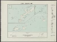
Okinawa-ken
Yale University Library
Yale University Library Digital Collections
Hyōgo-ken
Yale University Library
Yale University Library Digital Collections
![[歴民カード_歴史] 賀集美濃守安親下地寄進状](https://khirin-i.rekihaku.ac.jp/iiif/nmjh_rekimin_h/12849024_02.tif/full/200,/0/default.jpg)
[歴民カード_歴史] 賀集美濃守安親下地寄進状
National Museum of Japanese History
IIIF Discovery in Japan
「落葉集」
National Diet Library, Japan
ARC Ukiyo-e Portal Database

三笠会館
Samukawa Archives
ADEAC: A System of Digitalization and Exhibition for Archive Collections

「源氏五十四帖」 「夢浮橋」
National Diet Library, Japan
ARC Ukiyo-e Portal Database

Japan: Topography and industrial areas
Stanford University Libraries
Stanford Libraries SearchWorks

(Index Map) 77. Japan
Stanford University Libraries
Stanford Libraries SearchWorks

Yamaguchi-ken
Yale University Library
Yale University Library Digital Collections
Last Updated: 2020-04-17
Uploaded: 2021-09-21