
Japan : South coast of Honshu : Gulf of Tokyo or Yedo. Compiled from Japanese Government, and Brit...
- People
- Time
- Owner Organization

Ise Bay - North :
Yale University Library
Yale University Library Digital Collections

Oshima, south coast of Japan
Royal Museums Greenwich
Europeana API
Part of Japan or Nippon [east coast of Honshu Island, Japan] / T. Bowen, sct
National Library of Australia
Trove: National Library of Australia

Japan, Hokushu - South Coast. Uchiura Wan or Iburi Wan (Volcano Bay)
Stanford University Libraries
Stanford Libraries SearchWorks
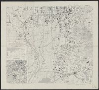
Kyoto South : Kyoto Prefecture, Honshu, Japan
Yale University Library
Yale University Library Digital Collections

Kyoto South: Kyoto Prefecture, Honshu, Japan
Monash University Library
Trove: National Library of Australia
![At Simoda [Shimoda], south coast of Japan](https://api.europeana.eu/api/v2/thumbnail-by-url.json?uri=http%3A%2F%2Fcollections.rmg.co.uk%2FmediaLib%2F537%2Fmedia-537405%2Flarge.jpg&type=IMAGE)
At Simoda [Shimoda], south coast of Japan
Royal Museums Greenwich
Europeana API

Habu Ko : Japan south coast O Shima
Monash University Library
Trove: National Library of Australia

Japan, Gulf of Ösaka, Hiogo and Ösaka compiled from British and French surveys to 1878
Boston Public Library
DPLA API

Osaka-Kobe area: Osaka Harbor and Osaka South: Osaka Prefecture, Honshu, Japan
Monash University Library
Trove: National Library of Australia
Japan (North) :
Yale University Library
Yale University Library Digital Collections
![Government railroads of Japan [cartographic material].](https://stacks.stanford.edu/image/iiif/kn953gw3179%2Fkn953gw3179_0001/full/!200,200/0/default.jpg)
Government railroads of Japan [cartographic material].
Stanford University Libraries
Stanford Libraries SearchWorks

Japan, North Coast of Hokushu. Wakkanai Ko
Stanford University Libraries
Stanford Libraries SearchWorks

Japan, Kyūshū--south coast : approaches to Osumi Kaikyo (Van Diemen Strait) (Eastern part)
Stanford University Libraries
Stanford Libraries SearchWorks

Map of Colorado Territory, Compiled from Government Maps & Actual Surveys. Made In 1861
Stanford University Libraries
Stanford Libraries SearchWorks

Map of Colorado Territory, Compiled from Government Maps & Actual Surveys. Made In 1861
Stanford University Libraries
Stanford Libraries SearchWorks

Map of Colorado Territory, Compiled from Government Maps & Actual Surveys. Made In 1861
Stanford University Libraries
Stanford Libraries SearchWorks

Map of Colorado Territory, Compiled from Government Maps & Actual Surveys. Made In 1861
Stanford University Libraries
Stanford Libraries SearchWorks
![[Fiftieth anniversary of cabinet government in Japan.]](https://api.europeana.eu/api/v2/thumbnail-by-url.json?uri=http%3A%2F%2Fwww.beeldbankwo2.nl%2Fcgi-bin%2Ffrsiserver.dll%2Fthumbnail%2F100170-thumb.jpg%3Ffrskey%3D100170&type=IMAGE)
[Fiftieth anniversary of cabinet government in Japan.]
NIOD Institute for War, Holocaust and Genocide Studies
Europeana API

Stanford's library Map of Japan / principally compiled from japanese documents, by E. Knipping
Bibliothèque nationale de France
Europeana API
![Japan, northeastern coast of Honshū and southern Hokkaidō [electronic resource]](https://www.gumtree.com/static/1/resources/assets/rwd/images/orphans/a37b37d99e7cef805f354d47.noimage_thumbnail.png)
Japan, northeastern coast of Honshū and southern Hokkaidō [electronic resource]
Stanford University Libraries
Stanford Libraries SearchWorks
Travelers' map of Japan, Chosen (Korea), Taiwan (Formosa) : with brief descriptions of the principal tourist points in Japan / Japanese Government Railways
National Library of Australia
Trove: National Library of Australia

Part of Japan or Nipon. (with) View of the coast of Japan when we first saw it (Engraved by) W. H(...
Stanford University Libraries
Stanford Libraries SearchWorks
Japan, East coast of Honshū, including Nampō-Shotō [electronic resource]
Stanford University Libraries
Stanford Libraries SearchWorks

Carte du Japon... / par Victor-A. Malte-Brun ; Gravé chez Erhard
Bibliothèque nationale de France
Europeana API

Japan, Hokushu _ West Coast. Iwanai Byochi and Approaches
Stanford University Libraries
Stanford Libraries SearchWorks

Nyūjōjiatō fukin sozu
Stanford University Libraries
Stanford Libraries SearchWorks

Provinces of Kansu and Ninghsia : Board of Economic Warfare / drawn in R. and A., O.S.S
Yale University Library
Yale University Library Digital Collections
Habu Ko : Japan south coast O Shima
Monash University Library
Trove: National Library of Australia

Tetsudō senro ryakuzu
Stanford University Libraries
Stanford Libraries SearchWorks
Corea and Japan
National Library of Australia
Trove: National Library of Australia

Rotatō
Stanford University Libraries
Stanford Libraries SearchWorks
Japan, Kyūshū--south coast : approaches to Osumi Kaikyo (Van Diemen Strait) (Eastern part)
Stanford University Libraries
Stanford Libraries SearchWorks

Kūchū shashin yōzu Sanman Gosen bun no ichi Bisumaruku Guntō Tsurubu - Busshingu Misaki kan
Stanford University Libraries
Stanford Libraries SearchWorks

Saipantō oyobi Teniantō
Stanford University Libraries
Stanford Libraries SearchWorks
![Gijigawan [cartographic material]](https://stacks.stanford.edu/image/iiif/sy999zz8762%2Fsy999zz8762_00_0001/full/!200,200/0/default.jpg)
Gijigawan [cartographic material]
Stanford University Libraries
Stanford Libraries SearchWorks

Katakiuchitsuzurenonishikiyakkoihei onoetamizou
Art Research Center, Ritsumeikan University
ARC Ukiyo-e Portal Database

Carte Des Missions Cathliques au Japan . . . 1898 (China and Formosa related insets)
Stanford University Libraries
Stanford Libraries SearchWorks
![Kūchū shashin yōzu Sanman Gosen bun no ichi Bisumaruku Guntō [cartographic material]](https://stacks.stanford.edu/image/iiif/sv955fw2847%2Fsv955fw2847_00_0001/full/!200,200/0/default.jpg)
Kūchū shashin yōzu Sanman Gosen bun no ichi Bisumaruku Guntō [cartographic material]
Stanford University Libraries
Stanford Libraries SearchWorks

Maris Pacifici Vulgo Mar del zur
Stanford University Libraries
Stanford Libraries SearchWorks

Australia - West Coast. Shark Bay
Stanford University Libraries
Stanford Libraries SearchWorks
Japan, the islands of Loochoo & Formosa, and the maritime provinces of China with the tract of the Morrison's voyage in 1837 / J. Arrowsmith, Lith
National Library of Australia
Trove: National Library of Australia
![Map of Manchuria, Corea & Japan [cartographic material]](https://collections.library.yale.edu/iiif/2/15828540/full/!200,200/0/default.jpg)
Map of Manchuria, Corea & Japan [cartographic material]
Yale University Library
Yale University Library Digital Collections
Charte von Japan mit seinen 7 Provinzen
Univerzita Karlova. Mapová sbírka
Europeana API
Asia and its several islands and regions : according to their most approved divisions with Captain Cooks new discoveries / by Thomas Kitchin, Hydrographer to His Majesty
National Library of Australia
Trove: National Library of Australia
![Tsu-shi kōkū shashin sokuryōzu [cartographic material]](https://stacks.stanford.edu/image/iiif/nw380zf1798%2Fnw380zf1798_00_0001/full/!200,200/0/default.jpg)
Tsu-shi kōkū shashin sokuryōzu [cartographic material]
Stanford University Libraries
Stanford Libraries SearchWorks

Mercury Bay to Town Point
Stanford University Libraries
Stanford Libraries SearchWorks

Seconde partie de la carte d'Asie contenant la Chine et partie de la Tartarie... : publiée sous le...
Bibliothèque nationale de France
Europeana API
Last Updated: 2020-04-17
Uploaded: 2021-09-21